
Back for a three-day stint as I continue my route up the west coast of Scotland. Due to the expensive cost of accommodation in and around Oban I decided to camp again, basing myself at the small campsite of Lagnaha, just north of Duror.
I catch the early morning 8:58 #418 bus to Clachan Bridge on the Isle of Seil. The forecast is turning out to be correct, with a gentle breeze and blue skies with no clouds to hide a very fierce sun. Today will be a mixture of road walking and a couple of off-road sections which I am not entirely sure about.

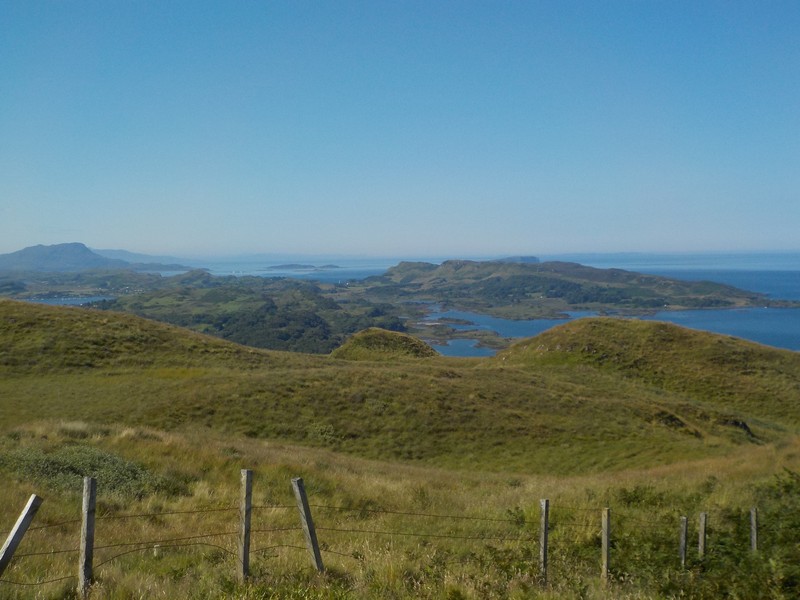
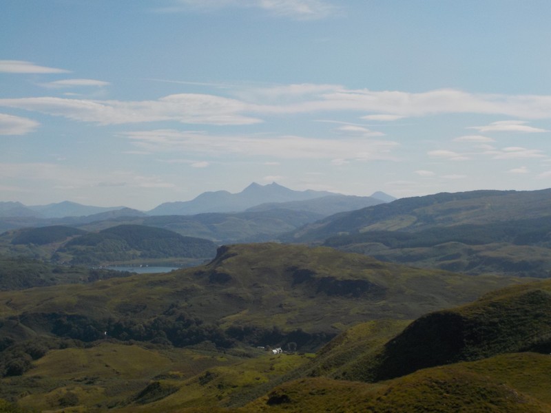
I set off down the B844, but as soon as I reach Clachan farm I turn off west along a good farm track which meanders north and takes me closer to the Marilyn Beinn Mhor (194m), which I intend to climb. I leave the track as it begins to head south again and negotiate a short section of bracken before reaching the trig point at the summit. Although the height is quite modest, the views from the top are magnificent. I look north to pick out the hills of Morvern and Ardgour and the pink scars of the granite quarries at Glensanda, the high tops of Mull are all clear; I can also look down on the Isle of Seil and pick out my route from two weeks ago. Cruach Scarba is still dominant to the south and to the north-east, the Munros of the Ben Cruachan group are all visible. I head due east of the summit making a descent down to the B844 road; the road is busy but vehicle speeds are being kept to a safe limit.


I arrive at the small hamlet of Kilinver which has a small church and a few houses. I take refuge in the church, seeking shelter from the strong morning sun and thankful for the cool and peaceful place to eat my lunch.
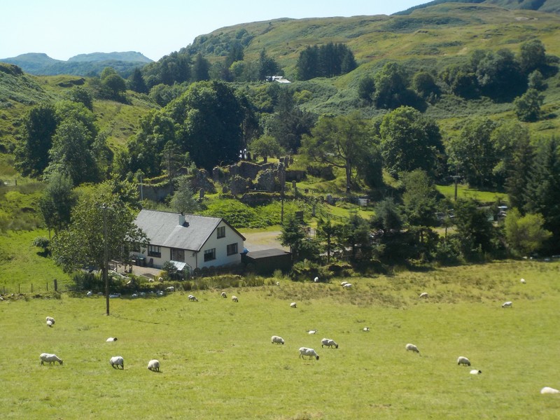
I soon join the A816, which is very busy with speeding motorists. The road hugs the shore of Loch Feochan, which I must walk around the head of. I am fortunate to have trees lining the road to give me shade from the midday sun. I enter Kilmore, another small hamlet with just a few houses, a village hall and a bus stop. Shortly after leaving Kilmore I begin looking for a track that will take me west cross-country to cul-de-sac road at Lerags. I walk over a small hill and look down on the hamlet of Lerags. I can see next to the farm what appears to be a ruined church and graveyard called An Tobar. I meet Liam Griffin, who lives, works and owns the land on which the church and burial ground stand. This is the church of St. Bride the Virgin Lorn and the burial ground of MacDougall chiefs. Liam and the Friends of Kilbride have done a tremendous job in clearing the site, revealing and preserving an important site of historic significance. However, the work is not complete and will require a significant investment hopefully forthcoming from Lottery or Historic Environment Scotland. If you are down that way, the site is well worth a visit.
http://www.friendsofkilbride.scot

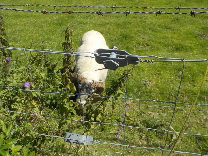
I set off down the road and get no more than 200m before I pass a small herd of Swaledale sheep in a paddock. One of the rams has got its horns well and truly tangled and stuck in some wire fencing. The sheep appears to have been in that position for a while, out in the sun and no access to water. I return to Liam’s farm and ask him who owns the sheep. Liam pops down the road to check the situation out; he meets one of the locals who has a set of bolt-cutters in his truck who quickly jumps over the fence, cuts the wire and releases the sheep. Job done, nothing more to see, move along please!
I continued down the road as far as Lerags Farm and turned off the tarmac road onto a farm track. I was trying to cut up the steep hillside, but after a couple of attempts I was getting nowhere; the bracken and the gorse was just too dense. I finally managed to find an old sheep track, which although overgrown with vegetation I managed to force my way through onto the open hillside. I was aiming for a tiny loch, Lochan Tri-Chrioch, at the corner of the forest, which would lead to a bealach and track down to Gallanach Farm. Well at least that was the plan, in actual fact the bracken had totally overgrown any track that was there. I had to beat my way through the head height bracken down over steep ground to a private road which ultimately lead to the public road. The demarcation between both roads was marked by a large locked gate. After carefully searching I was able to find a wooden pedestrian gate that was purposely disguised and hidden behind a large waste bin, which I had to push aside. Obviously, they don’t want people coming onto their land.


The rest of the walk back to Oban was along the narrow and busy coastal road along the Sound of Kerrara, passing the ferry point for the short journey across to Kerrara and then into Oban.

NB: I also publish all my Scottish Blog entries on the excellent Scottish Hills website, I use the same narrative, but larger photos and a few extra ones. They can be found here:
http://www.scottishhills.com/html/modules.php?name=Forums&file=viewtopic&t=23730
Distance today = 20 miles
Total distance = 2971.5 miles

Great photos. Fantastic views. So much of Scotland to look forward to!
LikeLike
Hi Ruth, yes the scenary is maginificent and is beginning to change quite quickly. I should reach Fort William on my next trip and make a start on the Ardgour peninsula, thats really when things get a bit more remote. I suspect should easily reach Mallaig before Christmas.
LikeLike