
I finally got two reasonable days in which I could continue my progress north up the West coast of Scotland. Mallaig marked the start of the more challenging part of my walk, with a series of lochs and high rough terrain taking you into remote parts with no B&B’s or buses. My destination would be Inverie on the Knoydart peninsular, which could be reached by ferry or the long walk-in. Although some “Coasters” opt for the ferry ride into Knoydart I had long since decided that I would walk in. In the past I had walked to the “fringes” of Knoydart in my Munro/Corbett Bagging days, but never all the way to Inverie. This meant I would have to back pack, carrying all that would be needed for an overnight stay. My plan was quite simple – Walk from Morar to Sourlies Bothy, cross the River Carnach, climb to the Mam Meadail, then down Glen Meadail to Inverie and a ferry back to Mallaig.
As I had already walked the 3 miles from Morar to Mallaig I parked in Mallaig and caught the 6:03 train to Morar. It was still dark when I got off the train and began the 3 mile walk to the end of the public road at Bracorina. I must confess I did not enjoy carrying the large rucksack with all that additional weight. I had used my large rucksack in the past and had never got on with it. I hoped to reach Sourlies bothy later that day and maybe sleep in the bothy. At this point I just did not know how far I would get or how I would feel. I soon reached the end of the public road and set off down a well made path along the north shore of Loch Morar. I passed the remains of the chapel at Inbhir Beag, once the main congregation place for people living around the loch. I pressed on in the early morning sunshine, passing by the ruins of the old settlement at Brinacory. It had turned out to be a glorious day with hardly a cloud in the sky and the snow-capped peaks reflected in a still Loch Morar.
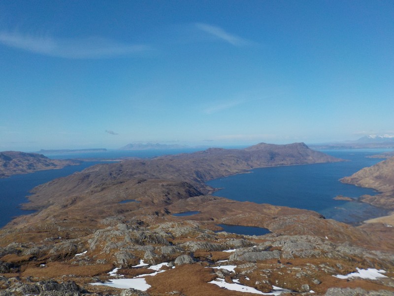
I eventually reached Swordland and its isolated holiday lets and shortly after South Tarbert Bay where there is a dramatic break in the high ground, enabling the portage of boats between Loch Morar and Loch Nevis through the narrow Glen Tarbet. I had considered following the southern shore of Loch Nevis, but from what I had read it sounded very rough going. I opted therefore to take the high route onto Sourlies. However, to do this required me to scale the steep-looking crags of Cnoc a’Bhac Fhalaicthe. I crossed over a fence stile and a short distance later a 8ft deer fence. It was very tough going and there were many moves up the steep rock which I could normally do, however, the large pack meant I was always top-heavy and really bulky. I was glad to top out and get a good view what was ahead of me. I did not bother using the map as the clear weather meant route finding was not a problem. My next destination was Sgurr Mor at 612m, although it was a case of picking the best route through the numerous bogs and knolls. The view from Sgurr Mor was excellent with Eigg, Rum and Skye all on show as well as the rough ground all the way back to Morar. I could also look ahead to Sgurr nan Ciche as well Beinn Bhuidhe across Loch Nevis.


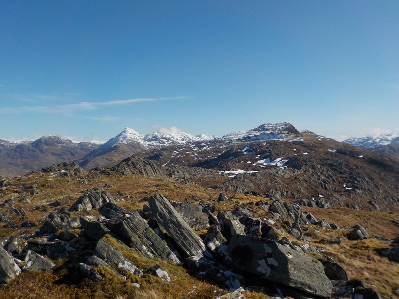


I had planned to stay high until Sgurr Breac, but decided to gradually lose height on its northern corrie. There were still large patches of snow which provided easy walking on the less steep bits. I walked around the rim of Coire na Murrach and across Coire na Caithris. I was able to see the houses at Camusrory in the distance and knew that I was close to the head of Loch Nevis. After spotting a ruin on the map below me I descended down steep slopes to the lochside. There was little or no path and the going was tough. Although the tide was out, walking along the shoreline was difficult because of the amount of kelp masking the rocks underneath. I rounded a headland and spotted Sourlies bothy. With the tide out I was able to almost take a direct line across the bay towards the bothy. The Finiskaig River at this point had diverted into multiple streams which made the crossing very easy. It was 14:30 when I arrived at Sourlies Bothy. The bothy was empty and I could see that a number of previous entrants were a group of Germans on an adventure holiday. I parked a chair outside and made myself a brew. I spent the next hour resting, taking in the views and …….thinking.


The crossing of the River Carnach was at the back of my mind. I knew that the bridge had been dismantled because of safety concerns and that I would have to cross the river somehow. I could have stayed in the bothy overnight or I could tackle crossing the river now. I felt good, my legs were good, the tide was out. I decided to cross the river, climb to the Mam Meadail and maybe camp further down in the Glen. I set off.
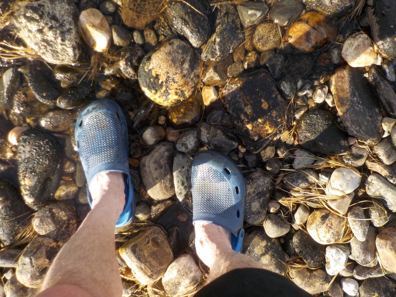
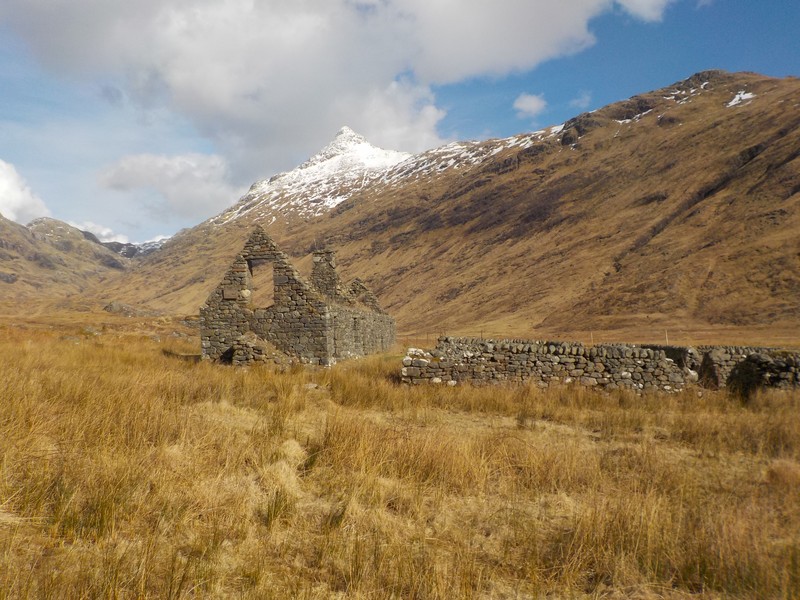
With the tide on the turn I just about squeezed the small headland at Strone Sourlies and made a b-line towards the ruins at Carnoch. I walked along the banks of the River Carnach and passed at least two easy crossing places which were quite shallow and an easy paddle. I arrived at the bridge and found the remnants strewn on the bank. I decided to cross the river about 50 metres upstream, but first I needed to change into my plastic “crocs” which I had brought with me. The walk across took 20 seconds, the water was freezing cold but below my knees. I was aware that people had lost their lives in this river while attempting to cross in far less favourable conditions.
I got changed and set off past the ruins to begin the slow slog up the Mam Meadail. It took over 1.5 hours to finally reach the bealach and I was quite exhausted when I reached the top. I was back at the snow-line and a brief hail shower appeared before the sun came out again. I could see the excellent path gently dropping down Glen Meadail towards Inverie. At this point it dawned on me that I could now make it all the way to Inverie! The prospect of a bed in the Foundation Bunkhouse at Inverie, not having to put my tent up, an early ferry the following day, maybe even a pint in The Old Forge? Spurred me on. I did not know if there were rules out about checking into the bunk house so I set off down Glen Meadail at a fair pace.


The early evening sun was falling on the snow and ice of Meall Bhasiter which made for a beautiful sight. By the time I reached the bridge across the River Meadail, the exertions of the day were starting to catch up with me. Although I had walked over this tracks 15 and 6 years ago, the final couple of miles into Inverie were exhausting. I arrived at the bunk house after 12.5 hours of continuous walking and I was really relieved to have a bed for the night. I could not make the half mile to the Old Forge, but I managed to “cadge” a tin of McEwans from Becky, one of the visiting students. I also managed to book myself onto the first boat the following morning.
A terrific and challenging days walk amid some of the best scenery in the UK. The next couple of sections northwards will also be difficult and I doubt I will carry a large pack again. I can just move much quicker and longer with the lighter pack.


NB: I also publish all my Scottish Blog entries on the excellent Scottish Hills website, I use the same narrative, but larger photos and a few extra ones. They can be found here:
http://www.scottishhills.com/html/modules.php?name=Forums&file=viewtopic&t=24046
Distance today = 26 miles
Total distance = 3,675 miles

Really nice trip – although I’d definitely have wanted to camp halfway!
We’ve had a plan to head out that Loch Morar track towards Bidean a Chabhair for a while. The track looks a lot more substantial than I imagined.
Cheers, looking forward to the future instalments. 🙂
LikeLike
Hi Kinley, in retrospect on reaching Glen Tarbet I should have continued around the south shoreline of Loch Nevis as far as Kylesmorar before getting up high, instead of negotiating the crags of Cnoc a’Bhac Fhalaicthe. Still trying to decide on the logistics of getting to the public road end at Corran, while covering the west coast coast of Knoydart.
LikeLike
What a walk! And with a heavy pack too. The views look amazing and you must have felt a wonderful sense of achievement.
LikeLike