
This was going to be a tough day in more ways than one. Firstly, it was something like 22 miles to Kyle of Lochalsh and secondly, there was still construction work going on along the A890.
There have been issues with rock stability between Attadale and Ardnarff for many years, especially where the road and rail routes come together and are pinched between the loch shore and the steep mountainside. The underlying problem is the presence of the Strathcarron Fault and nearby Kishorn Thrust, forming components of the Moine Thrust. The latest attempt to stabilise the rock slope is currently being undertaken with the road closed overnight and for long periods during the day. The opening times for the road was based around the train timetable and subject to a convoy system. To make matters worse pedestrians were not allowed to walk through the works, instead being carried inside one of the convoy vehicles – this was not an option for me.
I considered a number of solutions to get past the works on foot and walking around the site was the only option. I found it was not possible to walk on the shore side, between the rail track and the loch, as in many places there was a sheer drop from the track into the water. I decided that I needed to climb high up above the works to a height of about 350m just after Attadale. This height was important because it was above the very steep slope, above the forestry which spans the steep slope and importantly above a number of very steep ravines which cut into the slope.
I drove to and parked next to the rail station at Strathcarron. It was still slightly dark when I set off down the A890. I was wearing my hi-vis vest and strobe light head torch. The road was open at 07:00 so I knew I would see some traffic long along it.
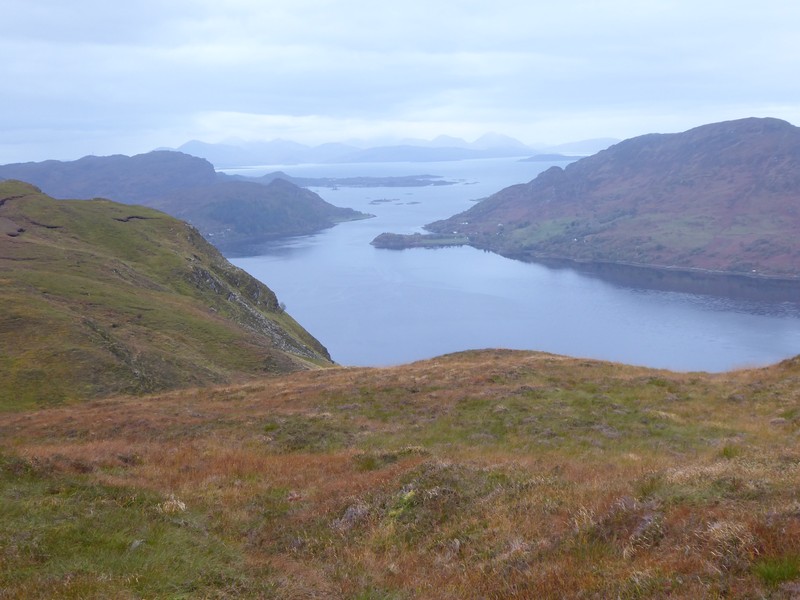
When I reached Attadale climbed a deer fence and set off up the hill. There was no path, but the terrain was not that bad, just steep. The steepness of the slope finally relented and the going became much easier. The 3 or 4 miles trek along the top was simply a case of keeping high on the undulating ridge, and maintaining a bearing between the hummocky knolls and boggy ground. Although I had extensive views over Loch Carron, I could not see down to the road works below me or even the forest. The route finding was quite simple as I navigated between a succession of small lochs. The key loch was Loch na Stroine, which I knew was close to the end of the road works below.
Getting off the hill and back down to the main road was the biggest challenge. I knew that there were forest roads running parallel with the hillside, but no paths or firebreaks linking them to the higher ground. I aimed for an old forest track, that I knew would be overgrown, but have a small distance to bash through to get to. I descended down very steep ground and had a few goes at getting through the forest. I finally emerged at what looked like an old road, very overgrown. I was very pleased with my navigation as I knew that this road would lead to a much more open forest road, and it did.


I finally arrived back on the A890 some 4 hours after setting off from Strathcarron, but I still had a long way to go. I continued along a very quiet A890 to the panoramic viewpoint above Loch Carron. I chatted to a couple who were selling coffee and snacks in the lay-by there. The coffee was a real tonic and tasted really nice. They offered me a free cup of coffee after they heard what I was doing, I politely declined as I had to get a move on, I had a train to catch.
I set off down the A890 and soon turned off the main road through Achmore. For the next 4 miles I continued along a quiet lane with the dramatic cliffs of Creag an Duilisg rising high above me. As I approached Duncraig Castle I was able to follow a footpath down to the railway line and pass underneath it and continue along a lochside path all the way to the outskirts of Plockton. I did not have time to walk into Plockton itself and continued along the road heading towards Duirinish. Duirinish was a unique little hamlet, with a row of cottages either side of a burn that ran through the settlement. Sheep grazed on common grazing land in the middle of the hamlet.


I continued on to the nearby settlement of Drumbuie and then onto Erbusaig with the road getting wider and containing more traffic. By the time I reached Badicaul I could see the Skye Bridge, albeit from a different angle. I passed into Kyle of Lochalsh and immediately looked for somewhere to eat. I did not fancy the cafe/bistro there so I popped into the Co-Op and bought some food. I had about 30 minutes before my train departed back up the line to Strathcarron. The rail journey was taken in the late afternoon light and I could still make out the landmarks I had previously walked along. It would be a superb journey to take the train all the way back to Inverness. As I passed by the road works on the train, my suspicions about being unable to pass between the railway and the shore were confirmed.
I would spend a third night in the car due to The Wee Campsite in Lochcarron being closed for the Winter.


NB: I also publish all my Scottish Blog entries on the excellent Scottish Hills website, I use the same narrative, but larger photos and a few extra ones. They can be found here:
http://www.scottishhills.com/html/modules.php?name=Forums&file=viewtopic&t=24371
Distance today = 22 miles
Total distance = 4,374 miles

Oh bad luck with the timing there. I was staying in Ullapool for a few days last week to walk more of the coast and got talking to an American couple staying at the same hotel about this road. They told me that they had to drive over the “railroad tracks” (their words). I thought they had got confused or something as I didn’t think that would be legal but I see this is actually the case – they put wooden boards over the tracks between trains or something and open it up as a diversion to the road. Never heard of that being done before!
LikeLike
Hi Jon, basically the amount of flat ground between the loch and cliff/hillside is minimal. There have been problems for many years and will be for years to come. Spoke to the Postie in Strathcarron and he said the latest cheapest road diversion would cost circa £100m, but the local Attadale Estate objected to the proposed route. He thought compulsory purchase may be on the cards.
LikeLike
Gosh what a tough route you had to take over the top. I did this walk today but the road is fully open again now so was able to follow that, though I did manage to walk on the foreshore on the coastal side of the railway between Strathcarron and Attadale as I found a path signed over the railway just outside Strathcarron and returned on a level crossing beside Attadale station (not quite sure if you are meant to use it, it was marked as a level crossing for “Authorised users only”). However I had to use the road the rest of the way to Strome Ferry.
LikeLike
I think my first post did not register. Just checked into my b&b. Did my penultimate walk in Scotland today north berwick to cockburnspath. Tomorrow will be the final one.good luck with the rest of your trip.
LikeLike
Forgot to mention good luck with the rest of the trip.
LikeLike