
I decided to skip ahead for the next section as it was to be a longer walk and would enable me to finish my walk sooner on my final day. This section also provided a significant challenge in terms of getting back to my starting point. Basically I would be walking between the ends of two public roads with neither linked by any public transport over an open moorland footpath unsuitable for bicycles. I was left with only two viable options either I could do an out-and-back to Craig Bothy (some 4km away) from Lower Diabaig and then do the same from Red Point on my next trip to the area OR I could simply do an out-and-back between Lower Diabaig and Red Point. I chose the latter preferring to get the section done and out of the way. Fortunately, there have been very few places over the years where I have had to double back in order to complete a section.
The first night at the Torridon campsite was extraordinary windy, with the tent threatening to take off with the onset of sudden and violent gusts. It made for a troublesome and disturbed nights sleep. The wind was still there when I returned from my walk, even though 300m away there was little or no wind.
I set off from Lower Diabaig just as it was getting light. Lower Diabaig is a very tucked away hamlet at the end of a tight, steep and winding road from Torridon. The final descent into Diabaig was very steep and I would not fancy travelling down it in icy conditions. I parked up at the small sea front. This walk would be virtually all over moorland footpaths, but I still had about 1 km to walk up a very steep access road to get to the start of the path. I decided to push my bike up the hill to the start of the path and then chain it to a post. The bike would make the return journey down the hill back to the car very quick.
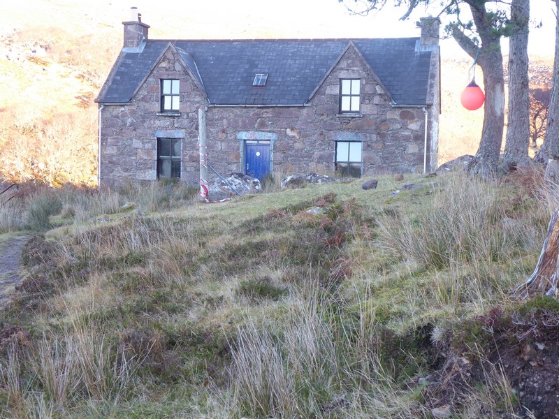
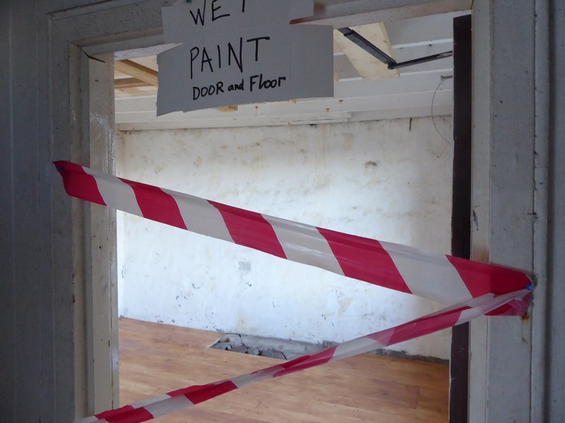
With the sun up and a beautiful cloud-free morning I set off on the first leg of the walk which would see me head for Craig’s bothy. The footpath out to the bothy was excellent and a pleasure to walk along. It was well-drained and often used bedrock, where it was close to the surface. I made good time to the bothy and decided to have a look inside. Surprisingly, checking the bothy book it had not been used for over a week.The most recent occupants had been a bothy work party who had completed some structural work to the floor on one of the lower rooms. This ex-YHA was in excellent condition and was spacious too, with 2 large and 1 small bedroom upstairs, together with the downstairs lounge (with offset kitchen) and a recently renovated room (temporarily closed).


The second leg of the walk from the bothy on to Red Point was along a path that was not 20 good. After crossing the nearby Craig River via a wooden footbridge, the path followed the river bank until the coast before heading north along the coast. Although the path was easy to follow, it was poorly drained and meandered quite a bit. About half way along the path I met a couple who were heading to the bothy. I thought they meant to stay the night, but I met them again on the trail later on my return from Red Point.
Eventually I arrived at the old fishing station. Here the ground became very grassy,helped by sheep and cattle grazing, a small sandy beach was close by with people walking along the shore. I walked through Red Point Farm and onto the car park at the end of the public road………………and turned around. Although it was still only 13:30, it was along way back, but with a cloudless sky I knew I would make it back to Diabaig before 16:00 and the sun going down.
I popped into the bothy again on my return to enter some details of my visit into the bothy book. I made good progress along the good footpath and arrived back at Diabaig just as the sun was dipping below the horizon.


NB: I also publish all my Scottish Blog entries on the excellent Scottish Hills website, I use the same narrative, but larger photos and a few extra ones. They can be found here:
http://www.scottishhills.com/html/modules.php?name=Forums&file=viewtopic&t=24406
Distance today = 17 miles
Total distance = 4,452 miles

How do you find pushing the bike and cycling back? I find pushing a bike a pain I usually seem to end up keep banging my legs into the pedals as I walk! Mind you I only normally end up doing so when my bike gets a puncture and the tyre goes so flat it starts to come off, so I have to push it home from work (which last happened a week ago).
I think if I had both a bike and car with me I’d be tempted to park up, cycle to my start point and leave the bike, then drive back to collect it at the end of the walk.
LikeLike
Hi John, I generally have no problem pushing the bike as I am quite adept at pushing with just my right arm, which means my legs are away from the pedals.
Normally, with a bike and car, thats what I normally do. However, irrespective of where you park the car i.e either A or B you will need to cycle at some stage and 45 miles which was the drive around from Red Point to Lower Diabaig was a no-go.
I’ve actually tried all combinations, walking to a dumped bike, getting a bus to a dumped bike, dumping a bike then getting a bus etc…
LikeLike
I did this walk a few days ago. It was wonderful! Like you I did an out and back walk of the whole path, but I started from the Red Point end instead. It is a tough walk, though it seemed less bad on the way back and as you noted the path east of Craig bothy is much better. The wooden footbridge over the river is missing a few planks, but not enough to make it hard or dangerous to cross. I stopped briefly in the bothy to shelter from a shower and noted from the visitors book it had been used every night for the past few nights at least. I hadn’t remembered when you were here, I should have looked in the book for your comment! I even noticed from the comments an HF Holidays walking group had stayed there a few days earlier, not sure I’d have wanted to lead a guided walk over that terrain though. I only saw one couple near to Lower Diabaig but that was all for the whole day. When David Cotton walked this part of the coast it was still functioning as a youth hostel.
LikeLike
Glad you enjoyed the walk Jon. I did this walk Mid-November and forget what I wrote then. Good to see you making progress down the West coast. Tomorrow I’m off for 3 more days, which should get me down to Portmahomack. I’ve done a rough calc, and have approx 71 more walking days until I finish this adventure, 32 of the days will be in Scotland.
LikeLike
I will be tackling this section on my next trip, so found your description very helpful. (Incidentally, I was trying to find a way back by public transport from Red Point to Lower Diabaig, and Google suggested an 8hr journey that involved a bus, train, an extensive walk and an Uber drive – so I guess it’s not really possible 😆) Plan to do two there-and-back walks instead. You were brave to tackle it all in one day, Alan.
Incidentally, despite all my anti-tick precautions, I managed to contract Lymes disease on my last trip to Scotland. Never saw the tick, but the rash is unmistakable! Feel well, but taking an extended course of antibiotics which make me allergic to sunshine. So unlikely to get back to Scotland this year.
LikeLike
Hi Ruth, crikey you must have been walking full time to get that far since June! I suspect you may have bypassed Skye the? Sensible to do the section in a few out and backs. You may want to do an out and back just to the Bothy at Craig.
Sorry to here about the Lymes Disease, as that been confirmed with test results? I have been bitten twice by ticks, one i got off by leg and the other on my bum! Fortunately no bulls eye rash which was some years ago. I think I got my ticks walking in Northumberland. Not sure what your precautions are, but I suggest that you treat all of your outer clothes (fleece/trousers/shirt/socks/gaiters) with Permithrin, wear gaiters, cover your arms, do’nt wear shorts and wear tights (which I do). Another good precaution is to wear Craghoppers which have the Nosilife tag, these are clothes that have inbuilt insect protection and are good for many washes – I use a base layer tee-shirt, a long-sleeved shirt, trousers and socks which are Nosilife.
LikeLike
Yes, I bypassed Skye. Actually been walking for many days this summer, but my daily mileage has been frustratingly low, so I feel my progress is snail pace!
As for the Lyme Disease, no I haven’t bothered asking for the tests, as I know the results are very unreliable in the early stages and (a) I didn’t want to wait and (b) wouldn’t have believed the test result anyway. Luckily NICE brought out some guidelines last year, and they have a flow chart which suggests that if you’ve been in a tick area AND you have the classic rash, you should diagnose Lyme’s without doing the test and go ahead with treatment. So that’s what I did, and actually bypassed the NHS and got a private prescription. (Yes, I was in a bit of a panic at the time!)
I do wear long sleeves, long trousers, tuck my cuffs into my socks, and check myself regularly, so was very surprised to discover I’d been bitten. But I have been staying in my campervan and I guess probably brought the blighter in on my clothing and then it transferred to my skin. I haven’t been using permethrin, so just ordered some from Amazon and thank you for that advice.
LikeLike
Hi Ruth, yes I forgot to mention go for the Lifesystems EX4+ Antimosquito Spray – you can also buy it from Go Outdoors
LikeLike