
I made a very early departure from my hotel in Rochester and set off to drive over to the Isle of Sheppey, a place I had never been to before. Even at 06:15 in the morning I could see the days were beginning to draw-out, with the glow from the SE starting to lighten the night’s sky. I drove to and parked in the small town of Queenborough at the library; the car park was free and close to the railway station.
I caught the 06:39 direct train to Gillingham. After popping into Greggs for a coffee and bacon bap I set off through the suburban part of Gillingham heading towards the Saxon Shore Way (SSW). I now have mixed feelings about the Saxon Shore Way, in places it is great and well signposted, in other places it makes pointless excursions and the signage all but disappears. I joined the SSW and stayed on it for about 300m, but then decided to transfer to the nearby road, which had an excellent footpath. I continued along the B2004 until Lower Rainham where I met a dog walker and enquired about the footpath ahead. The news wasn’t good with only intermittent footpath sections and little verge along a busy road. I returned to the SSW.
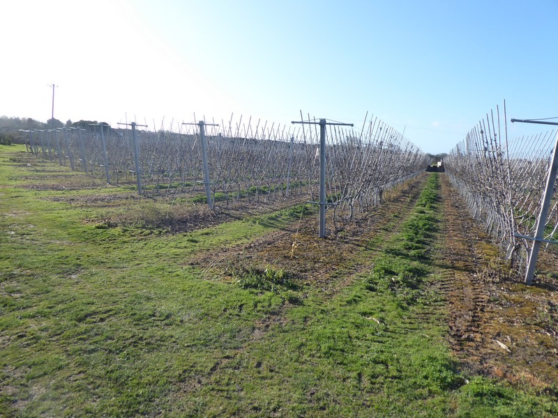
I passed by Bloors Wharf, long since flattened and cleared of buildings, with only the occasional mooring post still visible. I followed the SSW out towards a sewage works and then back along Otterham Creek. I passed around a couple of factories and then a few orchards before emerging on a minor road which was far from quiet! In fact, it was damm dangerous as I had to hold myself in the bushes to let cars through and also have eyes in the back of my head! I was on this road for about 800m and successfully missed the SSW turning off the road. This meant I arrived in the village of Upchurc, slightly off route. Annoyed with the SSW, I plotted an alternative route to get me to Lower Halstow where I could re-join the SSW. This worked out quite well and was traffic -free.


The SSW out of Lower Halstow was through a number of horse-paddocks before re-joing the road. The SSW then began to rise towards a short ridge which gave good views across the Medway Estuary to the Isle of Grain. I soon lost any signage for the SSW and could see where people had climbed barbed wire fences and trampled through dense undergrowth in search of the path. The shoreline was only 200m away and I finally gave up with searching for a non-existent path and returned to the road. The road was quiet and quicker which resulted in me making quick progress towards Raspberry Lane. The SSW finally joined the road and crossed over outwards Chetney Marshes, although it only went part of the way. I made the decision to stay on the road, the road bridge across to the Isle of Sheppey was only about a mile away now.
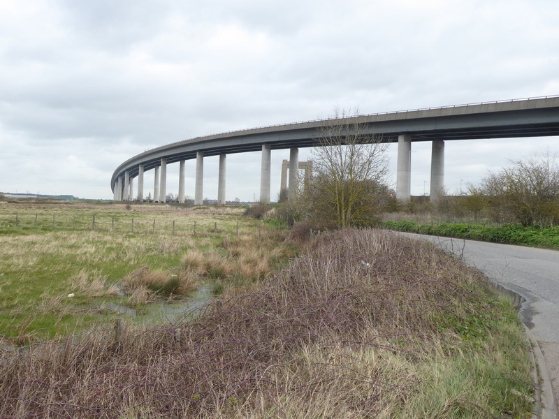
I arrived at the Kingsferry Bridge which carries trains, as well as cars, pedestrians and other traffic were not allowed to cross the main Sheppey Crossing. The bridge towered above me as I passed underneath it amongst the huge support pillars. I was heading for a marked footpath on the map that headed across fields towards Rushenden and then on to Queenborough. A finger post on the main road pointed the way, but that was the last I saw of any footpath signs. The sea bank had no right of way on it, yet was covered in deep mud from use by off-road motorcycles. I took my compass out setting a bearing towards The White House (on the map) which no longer existed. The large water-sodden field was occupied by grazing cattle which made the underfoot conditions worse. I could not find a way through or around as the railway line, with its ‘live’ rail track was on my right. I retreated after about 30 minutes back to the bridge, totally covered in mud.
I followed the B2231, which had a wide and excellent footpath towards Queenborough. The B road ran adjacent the busy A249 which used the main Sheppey Crossing. It required another section of non-footpath road walking to get to the outskirts of Queenborough and thence pick up a path.
Again not a good days walking and looking ahead access issues on the Isle of Sheppey which will probably mean a shortened visit to the island.


Distance today = 17 miles
Total distance = 5,894 miles

I had real problems with this walk too, especially the part on the Isle of Sheppey. The footpath past White House was closed and fenced off when I was there, though there was an official notice giving it’s closure. This was before the new Sheppey bridge had opened so then the only way on and off the island was (what is now) the old lifting bridge, now the B2231 but back then it was the A249 (now a dual-carriageway). So it was exceptionally busy so I decided to give up on that part of the walk and take the train from Swale to Queenborough instead. As this wasn’t the mainland anyway I didn’t consider it cheating. I guess at least the B2231 is probably now pretty quiet with the new road taking most of the traffic.
There is some nice scenery on a few parts of the north coast of the Isle of Sheppey (Waren to Minster) but most if it is not very interesting I’m afraid.
LikeLike
Hi Jon, I was going to make a trip to Sheppey tomorrow to complete a circular walk out to Leysdown and back to Queenborough, while strictly observing “social distancing”, but my heart was not in it. Don’t know when I’ll get out next. Cheers.
LikeLike
Looks like a return to Scotland might be on the cards soon? I’m certainly hope so! I hope all is well with you and your family.
LikeLike
Hi Jon, yes I think we are looking good to go both in England and Scotland (after the 15th?). Anyway, on Sunday I am going back to the Isle of Sheppey for 2 days of walking. I’ll be walking from Queenborough to Leysdown and then a circular walk out to the Isle of Harty – almost mirroring your walk some years back. I’ll be doing it slightly differently though by walking along the beach from Minster to Leysdown. I’ll be walking into an ebbing tide, it is possible to get through and I did not really fancy road walking on a Sunday afternoon! I’m staying in a B&B on Sheppey then retracing my steps to Swale and onto Faversham on Monday.
I ‘ll be hopefuly getting up to Aberdeenshire in a fortnight. Good luck with your trip. Cheers
LikeLiked by 1 person
Good to hear you’ll be back on the coast. I heard another walker did the beach walk along the Isle of Sheppey, definitely looks a better route than the one I took, though take care as a house fell of the cliff there a few weeks ago (you probably saw it on the news).
LikeLike
I recently tried to circumnavigate Sheppy and found a couple of problems. The first makes a big difference to trying to walk a loop – a very short section of private land. The second was a lack of footpath markers. I was walking anticlockwise from Queenborough. Sheppy is more like a there and back around the north side of the island, not a coastal loop.
As we approached the end of the loop through Elmley Marshes, the footpath runs out (grid TQ9970). The short section of road back to the B2231 is marked as private land – this is only clear very close to the end of the 8km or so section from Kings Hill Fm, where a sign from the council has been put up. The farmer came down the hill to meet us in his truck and thankfully he granted us permission to pass through. Given the number of no entry signs, I guess he would probably not do this on busier days. I’m not sure I could face the long loop back round, and I assume there no path through the prison. Lots of standing water and channels across the surrounding fields limit options. Emerging onto the B2231 it is a fast road with no pavement, so we cut short our loop there and headed north-east to Minster. I would not recommend walking on this section of the B2231
Which also brings up a second point. There are virtually no footpath signs showing the public route through the Elmley Marshes (although plenty of signs up stating ticket prices to access the reserve). However there is a sign up on a locked gate around TQ9567 that says the [foot]path is closed because of nesting birds. I chose to ignore the shut sign, and hopefully not to the detriment of the nesting birds was able to cut through the marshes. I’m confident that if you followed the route suggested on the close sign, around Spitend Point to the advertised hide, there was no through route to rejoin the public footpath near Dutchman’s Island (not clear if the standing water/flooding was permanent), indeed there was a high fence that deliberately prevented this.
LikeLike
Hi Paul, thank you very much for this information. I am afraid you have confirmed what I already suspected and that my ‘loop’ around Sheppey may be more of a squashed-ovoid in shape! I may try and get as far as Leysdown and try and work my way back to Queenborough just slightly to the south of my outward route. I tend to use Google streetview a lot in deciding what roads to walk along. If there is a reasonable verge, then I am happy with that. On my last trip I had to press myself into hawthorn hedges when traffic passed either way past me and that was on the Saxon Shore Way!
I have found the online OS 1:25000 to be woefully out of date on many of the coastal sections I have passed through.
Many thanks again for your advice. Hopefully it will not be too long for us to get back out again. Cheers
LikeLike