36. Falmouth to Helford Passage

walk361
Unloading the moped at Helford Passage

Today is a short walk from Falmouth to Helford Passage. As public transport is not readily available I drive to Helford Passage and park my Doblo van in a car park next to the Ferry Boat Inn. I then use my moped to drive back towards Falmouth from where I begin my walk.

walk362
Falmouth Harbour

Falmouth is a very interesting town, steeped in maritime history and offering a fantastic anchorage for all types of ships. I begin my walk at the pier from which the ferry departs for St Mawes and thence on to Place. I walk through the main high street and down towards the train station and docks. I spot a number of Royal Navy ships alongside the docks and get a fantastic view of a dry dock.

walk363
Maenporth
walk364
Helford Passage

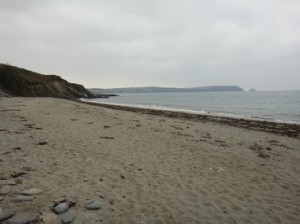
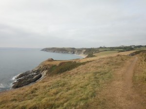
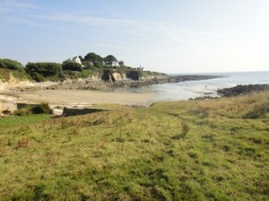
The road goes out towards Pendennis Point, where Pendennis castle sits atop the promontory. The road which encircles the castle was used as a road race track from 1934 – 1936 for motorcycles and light cars. As I round Pendennis point I see the back shore of Falmouth stretching to Swanpool beach. The walking is along a promenade which offers very easy walking. I climb up and walk towards Pennance Point with its Home Guard monument before  descending to and walking around the small cove of Maenporth. The remainder of the walk is a delightful stroll through open fields, in which the path rises and falls gently offering excellent views across the Helford River to its southern bank. I pass close to the village of Mawnan and through Durgan before finally arriving at the Ferry Boat Inn at Helford Passage. This delightful walk has taken just 2.75hrs.


Distance today = 10 miles
Total distance =   545.5 miles


35. Portloe to Place

It’s a lovely calm and sunny day as I continue on my journey towards Falmouth. I will be walking out onto the Roseland Peninsula that ends at The Carrick Roads, the large flooded ria that gives Falmouth its unique position. Getting to and from Place is difficult using public transport, so I make use of my moped by dropping it off there and then driving around to Portloe.

walk351
Underground water reservoir or WW2 buildings?
walk352
Nare Point from Pendower Beach

The first couple of miles of the path is done on high cliffs with slumped highly overgrown slopes. The path follows the inundated coastline around Manare Point, Blouth Point and Nare Point. Nare point used to be known as Penare Point for some reason the “Pe” was dropped. Most of this coastline is owned by the National Trust, which include a number of tenanted farms. I pass some strange underground ventilation structures which I suspect may be World War 2 underground buildings.

walk353
Portscatho
walk354
The route ahead towards Greeb Point

After a few steep up and downs I finally descend to Pendower and Carne Beach. There are few people about and I more or less have the beach to myself. After a couple of fairly easy miles of walking I pass a look-out station and get my first good sight of the fishing village of Portscatho. Just before I reach the beach, I find a wooden bench and eat my sandwiches. The weather has held and I have made good time. I climb out of Portscatho and am rewarded with a view all the way to Falmouth, I can see the path falling and rising gently which looks very inviting.

walk355
St. Anthony’s Battery
walk356
Place House, St Anthony
walk357
St Mawrs Ferry

I round Greeb Point, Killigerran and Porthmellin Head before continuing onto Zone Point. From Zone Point I walk a few hundred metres to St Anthony’s Head and enter the Coast artillery fort of St Anthony Battery. Although long since used as a military base, the National Trust has made preserved the defensive structures of the Battery as well as converting some of the buildings into holiday lets. This battery was one of a numberf which guarded the entrance to the Carrick Roads and the port of Falmouth. The battery has a number of visitors and I explore the remnant artillery structures on show. I pass the squat little lighthouse built-in 1834 and head off towards Carricknath Point, passing small tiny coves with people simply paddling, sunbathing or exploring rock pools. I have passed the tip of the Roseland peninsula and am now walking eastwards before dropping down into Place. I can see St. Mawrs just across the water. I pass the 12th century church of St. Anthony and the striking Place House with it large sweeping lawn all the way down to the shoreline. A few hundred metres further on I reach the small jetty for the St Mawrs ferry. It has taken me almost 5 hours to get here.

Distance today = 13.5 miles
Total distance =   535.5 miles


34. Pentewan to Portloe

The second day of my two-day trip to Cornwall…….and it was going to be another very hot day. I parked the van just outside of the village of Portloe, at a free car park, which was just a few hundred yards from the coast. I then got on my moped and drove to a lay by on the B3273 just outside of Pentewen.

walk341
Mevagissey

As I locked my helmet away, I could already feel the heat even though it was only 9:00 in the morning. I set off over fields and picked the SWCP path up. I head out to and rounded Penare Head before dropping down into Mevagissey. Mevagissey is perhaps one of the best and most picturesque Cornish fishing villages, with its multi-coloured houses rising steeply above the harbour. The village was quiet when I passed through, but I saw a number of people taking their breakfast out on their veranda’s. I remember many years ago doing a large jigsaw puzzle of Mevagissey, I was just as impressed then as I was now by this charming village. I passed around a small headland into Portmellon, which is now officially part of Mevagissey.

walk342
Chapel Point

The path now follows a private drive which leads down to three striking houses at Chapel Point. The walking is very easy here along a low-lying grassy track that bears right before the three houses. In the distance I can see Gorran Haven, my next fishing village. Gorran Haven is another beautiful little village, with very narrow streets, a small beach and the church of St. Just. I continue through narrow streets, sorely tempted by the smell of bacon baps!

walk344
Dodman Point

I continue around Maenease Point and head south along the high cliffs towards Dodman Point. At Dodman Point I note a large 20ft granite cross, which has been used as a Day Mark. A group of people are engaged in a conversation, they do not acknowledge me so I do not linger. The Point does however, offer a superb vista up and down the coast here. I’m now heading north from Dodman Point

walk345
Highland cattle
walk343
Gorran Haven

Just after Hemmick Beach I pass through a small group of Highland cattle, although ferocious looking they are indeed a very gentle animal. By the time I reach Porthluney Cove near Caerhays Castle it is has become very hot. I seek some shelter from the sun in a refreshment building  in the car park where I purchase an ice cream and top up on fluids. The car park is very busy and is the main car Park for the castle, which was built-in 1808 and designed by John Nash.

walk346
Caerhays Castle at Porthluney Cove
walk347
Portloe

The path climbs up above the cliffs again before dropping down to the twin-hamlets of East and West Portholland. The climb up and out of the hamlets is tough, as the afternoon sun is ferocious nad fatigue is starting to set-in. It therefore comes as quite a relief to come into the small village of Portloe. I resist the temptation to partake of an ice-cool cider in the hotel that I pass. But I’ve still got about a mile of walking still to do. The 14 miles takes a leisurely 6hrs. A lovely days walk along a stunning coast.


Distance today = 14.5 miles
Total distance =   522 miles


33. Pentewan to Gribbin Head

Today was a very hot day and although I only had a short distance to walk, I had been suffering from a thigh/groin strain which although not very painful, was a persistant dull ache. I had dumped the moped at the free car park at Menabilly near Gribbin Head and then drove the short distance west along the coast to the layby on the B3273 just outside of Pentewan.

Looking back at Pentewan
Ther view towards St Austell and its distinctive spoil heaps

I set off along the B3273 into Pentewan and enter the village walking around the small man-made harbour, past the Ship Inn and up Pentewan Hill. The path rises and falls through a number of steep up and downs. I head towards the promontory of Black Head, which is owned by the National Trust and home to an Iron Age fort. From nearby Gerrans Point I have a sweeping vista northwards towards St Austell, which I can see in the distance together with a number of distinctive volcano-like white spoil heaps from the china clay quarries. I drop down into the small village Lower Porthpean and walk along a quiet Porthpean Beach.

Charlestown wharf

I climb up a small hill onto Carrickowel Point home to the ruins of the Crinnis Cliff battery. I had a search through the overgrown wooded area , but little evidence remains of the gun positions, originally built to guard Charlestown. I enter Charlestown, which has a small well-preserved dock and is probably easily recognisable to those who watched the TV series Poldark. I pass by a couple of old sailing ships tied up alongside the wharf and walk past the Shipwreck and Heritage centre. It is getting quite warm now as I head towards Carlyon Bay, with the path walking alongside a golf course.

Looking back at Par Sands

I soon have to make a large detour inland around the large Imerys industrial site for the drying and milling of China Clay. The detour requires me to follow the main road into Par, where I replenish my water and food stock. A small footpath then leads back to the beach,  with a number of signs depicting scenes from the processing of China Clay. I head across the beach at Par Sands, it is very quiet, with few people enjoying the very hot afternoon.

The beach at Polkerris

I leave the beach and ascend some steps to join the path which now heads south towards Gribbin Head. I descend steeply to the small fishing village of Polkerris. The small beach is very busy and the pub, the Rashleigh Inn is also busy. It’s very hot now, but I’ve only got a few miles to go now. I climb up steeply through a wood from Polkerris and have an easy walk along the cliff top to Gribbin Head. It has taken about 5.5 hours.

Distance today = 12.5 miles
Total distance =   507.5 miles