152. Lochgoilhead to Dunoon

Todays walk was to be predominantly along roads, off-road footpaths and forest tracks keeping to the lochside for virtually all of the route. My plan was to get to at least Ardentinny, when I would then have the choice of completing the journey back to Dunoon by bus. In the end I made it all the way to Dunoon on foot, even if it did mean finishing in the dark.

To get these long walks in you need to start very early at this time of the year, so I caught the 6:58 #484 bus from Dunoon to Lochgoilhead; at only £3.60 it was fantastic value for money for a journey lasting over an hour and 33 miles. We had had another severe frost, which meant clear skies as I arrived at Lochgoilhead. Apart from yesterdays walk I had only previously visited this area before some 5 years ago while climbing a singular Corbett, Beinn Bhuela, which rises above the village.

walk1521
Looking north up Loch Goil to Ben Donich

Although it was not completely dark I began my walk with head-torch and hi-vis vest on. The road I was heading down was in fact a cul-de sac, but there was the odd couple of cars coming down along the road. From the bus stop I walked along the shore to the golf course and crossed the small burn by a wooden footbridge onto the Carrick castle road. Although it was very cold I soon warmed up with a brisk pace. I had lovely views to my left across Loch Goil of yesterdays high walk above Loch Goil. The ridge looked very knobbly from down here.

walk1522
Early morning amber-glow at Carrick Castle
walk1523
Forestry Commission car park at Ardentinny

It took about an hour and half to get to Carrick Castle. The 15th century tower house that is Carrick Castle is now in private ownership and is currently being restored, as I saw with scaffolding and building materials stacked up outside. Not far after Carrick Castle the public road ends. This is where the Forestry Commission footpath takes over for the 4 miles to Ardentinny. The path is a mixture of an off-road footpath and forest road. The route is well-marked and a popular attraction. I make good progress along the path which ends at a large Forestry Commission car park just before Ardentinny. I also finally say goodbye to Loch Goil as I rejoin Loch Long.

walk1524
Submarine in tow up Loch Long

As I walk through Ardentinny, something out on the loch catches my eye. It’s a small flotilla with a Royal Navy vessel escorting a submarine that is being towed and pushed by three tugs, with another escort vessel bringing up the rear. The conning tower has a huge pipe with steam coming out of it and is bedecked with engineers in orange overalls.

walk1525
Hunters Quay across Holy Loch from Strone
walk1526
Argyll Mausoleum at Kilmun Church

I have a couple of miles of road walking with no footpath as I make my way to Blairmore. At Blairmore, I look across Loch Long to see the end of the Roseneath Peninsula and also Loch Long. I now have a wide panoramic view out across the Firth of Clyde towards Greenock/Gourock and even Dumbarton Rock. As I pass through the small village of Strone I pass into the rather small sea-loch  of Holy Loch. The loch is quite narrow as I can see Hunters Quay quite easy on the far bank.

walk1527
Mortsafe at Kilmun Church
walk1528
Kilmun Church – Old and New

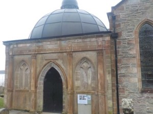
It has become quite overcast now, but still dry and streetlights are starting to come on. My legs are feeling fine, but I could do with some food as I hadn’t bought any with me! I soon forgot about my stomach when I came to Kilmun Church and I realised why Holy Loch is called Holy Loch! Kilmun Church is a fascinating place and I spend a short time looking around the old graveyard and the


church. I would have liked to have spent more time here, but with the failing light I must push on.

At Kilmun Turn, where the road joins the A815 I pop into a service station to get some food. As I come out,  I bump into a fellow “Shiller” in the form of Diane, of TwinAscents fame. In retrospect I should have spoken and introduced myself but I wasn’t 100% certain it was her. You Know embarrassment and all that!

By now I knew my legs would carry me the whole way to Dunoon. I’m also on well-lit pavements, so no real worry. I turn off the main road into Dunoon, to follow the coastal road through Ardnadam where I have a conversation with a dog-walker about the Amercian Submarine base when it was here. He tells me as a young lad he was one of the protesters camped out near the base at the time. I continue on to Hunters Quay, but not before popping into the ticket Office for Western Ferries to buy a ferry ticket for tomorrows return home. I find that buying tickets in advance and multiple gives you substantial savings. I bought a 2 journey ticket for car and driver for £17.

By now its dark, but I am walking along the promenade through Kirn and into Dunoon. Gourock is lit-up and seems very close, well actually 2 miles away. I walk straight to my B&B which is on the sea front. I have been walking for 9 hours and decide that I will give tomorrow a miss as wet and stormy weather is forecast.

NB: I also publish all my Scottish Blog entries on the excellent Scottish Hills website, I use the same narrative, but larger photos and a few extra ones. They can be found here:

http://www.scottishhills.com/html/modules.php?name=Forums&file=viewtopic&t=23090

Distance today =   27 miles
Total distance =    2547 miles


151. Arrochar to Lochgoilhead

Today it was back to Scotland for a two-day trip continuing around the Clyde Sea Lochs. Todays walk would be different in that I intended to include some of the higher mountains between Arrochar and Lochgoilhead. The reason behind this was that in 2012 I completed the Corbetts (hills between 2500 to 3000 ft), but unfortunately the “meddlars” re-surveyed the Graham – Cnoc Coinnich (hills between 2000 to 2500 ft) and the result of the survey was that Cnoc Coinnich was indeed now classified as a Corbett and I hadn’t climbed it. I had therefore decided that I would climb Cnoc Coinnich and Ben Reithe when I walked from Arrochar to Lochgoilhead. I had not climbed any mountain above 300m for some 2 years so I was looking forward to this. I finally got a small weather window so off I went.

walk1511
Looking down Loch Long from Arrochar – with wooden carving and mountains on right yet to climb
walk1512
Near Forestry Commission car park on The Dukes Path
walk1514
Hills to the north with The Brack in the foreground and The Arrochar Alps behind

As I parked up in Lochgoilhead I could see that no hills had any snow on them at all, including the ones I intended to climb. So I discarded my ice axe and crampons and caught the 09:00 #302 bus to Arrochar. At Arrochar I set off immediately walking back down the busy and noisy A83. There is a footpath along the main road all the way  to Ardgartan where I took a woodland path that ran alongside the main road for 400m until I came to a small wooden footbridge that took me over the small burn. I emerged onto the minor public road that rose to a Forestry Commission car park at about 130m at the foot of Glen Coilessan. Since Ardgartan I had also been walking along The Cowal Way which climbs over the bealach between Cnoc Coinnich and The Brack, before dropping down into Lochgoilhead. Besides forming the Cowal Way, the access road continues around this peninsula, albeit as a cycle-track. I notice on the signage that it is referred to as The Dukes Path and I will join up with it again later on in the afternoon.

walk1513
Looking back down to Arrochar and Loch Long with Loch Lomond and Ben Lomond in the distance
walk1515
Looking south into the blinding sun with Ben Reithe and The Saddle in the foreground and the Roseneath Peninsula just visible in the distance
walk1516
The steep descent off Cnoc Coinnich
walk1517
Looking back towards Ben Reithe

At the bealach I make my way up steepening slopes to gain the ridge line of Cnoc Coinnich. Although the sun has been out since I started walking this morning it was only now that I was walking directly into it, and it was blinding! At the summit of Cnoc Coinnich it restricted my view to the south as well as trying to take any decent photos. However, there were terrific views still to the north and west, with the Arrochar Alps and hills of the Cowal peninsula standing out in particular. I could also make out to the south the Roseneath peninsula, The Gare Loch, Loch Long and Loch Goil stretching into the distance and into the Firth of Clyde. Unfortunately my ‘cheapo’ camera and the aspect of the sun could not do the view from this hill full justice, so if you want to see  much clearer views in their splendour then follow the link below to Trekpete’s TR of his visit to the area in 2013:


http://www.scottishhills.com/html/modules.php?name=Forums&file=viewtopic&t=15649

It had taken me almost  3 hours of walking since Arrochar to reach the summit of Cnoc Coinnich and I must have stopped about 10 times to catch my breath, yes walking uphill takes more out of you. After negotiating the steep descent off Cnoc Coinnich I now had almost 2 miles along hummocky, boggy terrain towards my next objective Ben Reithe. Although lower than Cnoc Coinnich, Ben Reithe still had magnificent views, particularly to the south, although I had to squint with the blinding sun. Like Cnoc Coinnich, Ben Reithe had a steep descent on its southern limb, which required care to navigate around the small crags here and there.

walk1518
Corran Lochan

My next objective was The Saddle, which was lower still, but this time I was heading towards its eastern flank to pick up an ATV track which would descend down to the Dukes Path. I managed to locate the ATV track and 15 minutes later I arrived back on the Dukes Path. Most of the forestry roads I had been walking on during the day had been recently upgraded, a prelude to a probable commencement of forest operations. After a mile the Dukes Path arrived at the upland loch of Corran Lochan, a delightfully secluded loch below Clach Bheinn. Here the path turned north, as the sun began to disappear below the neighbouring hills.

walk1519
Approaching Lochgoilhead late afternoon

I continued along the path until I crossed the Stuckbeg Burn, where I met a local gentleman who was out from Lochgoilhead on a late afternoon stroll. He suggested that I descend down the Stuckbeg Burn path to join the main forest road back to Lochgoilhead. By the time I reached Lochgoilhead the sun had long since disappeared below the hills of Cowal. I now had the long drive around to Dunoon where I was staying for the next two nights. The walk had taken 6.75hrs.

NB: I also publish all my Scottish Blog entries on the excellent Scottish Hills website, I use the same narrative, but larger photos and a few extra ones. They can be found here:

http://www.scottishhills.com/html/modules.php?name=Forums&file=viewtopic&t=23078

Distance today =   18 miles
Total distance =    2520 miles