Today I had decided to scale back my route, as walking all the way to North Ballachulish was rather optimistic and more importantly the weather forecast had changed from a some rain to heavy rain all day! Walking a long distance in heavy rain is not particularly enjoyable, so I decided to cut short my day. So few photos and little narrative – sorry.
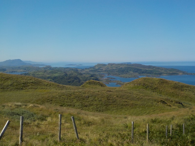
I had opted to do a short section around what is called the Appin Loop, following a minor road around a small promontory of land bounded by Loch Creran and The Lynn of Lorne.
The rain started bang on forecast at 07:00, just as I was packing up. I drove down to Creagan Bridge and caught a bus up to Appin. The rain was incessant when I began walking down the road towards Port Appin. Out of the gloom I could just make out the wooden Jubilee Bridge crossing the shallow Loch Laich; behind the bridge I could also make out the distinctive shape of Castle Stalker on its own small island. The walk along the road had me walking head down and just intent on covering the miles, the overcast rain filled skies offered little views and few photo opportunities.
I passed Port Appin, where the ferry runs over the short distance to the Isle of Lismore and continued through the rain, not meeting a single person or car. By the time I reached a place called Rudha Garbh I was thoroughly soaked. After almost 3 hours of walking I was back on the A828 by which time the wind had got up as I followed the cycle track back up to Creagan Bridge.
Being retired I can pick my days when I walk and after two previous days of glorious weather, todays washout was not a big disappointment.
A very wet AppinA very wet view across the Jubilee Bridge to Castle StalkerA very wet view of the path to the Jubilee BridgeA very wet Port AppinA very wet view of the road back to Creagan Bridge
Distance today = 10.5 miles
Total distance = 3000.5 miles
Today should be slightly easier than yesterday with no serious off-road sections planned. I should be walking predominantly on footpaths, cycle tracks, quiet roads and a bit of A85 verge hopping. It was a beautiful start to the day, with a full sunny day forecast. I hurried my breakfast down as the midge were out in force
I drove to and parked at Creagan Bridge and caught the 8:16 #405 bus to Oban. The bus was full of tourists and people going to work. When I arrived in Oban the place was very busy, even at this time of the morning. I could see a large cruise ship, The Aegean Odyssey, had anchored just off-shore and its three tender vessels were busy ferrying its passengers into Oban. I spend some time admiring printed copies of famous classical paintings hung on the exterior of the Oban chocolate company building. The paintings had been cleverly doctored to include a chocolate theme.
Tender vessel ferrying cruise liner passengers ashore at ObanThe Arnolfini Portrait by Van Eyck – entirely appropriate that a painting full of symbolism has been “re-mastered” with chocolates and a pussy-catBlack Guillemote – Oban
I followed the coast road past the cathedral and lighthouse and onto Dunollie Castle. The road dropped down to a newly built estate of private housing at Ganavan Sands, at which there is a large car park and small sandy beach. I turn inland slightly up a newly constructed cycleway, part of the Caledonia Way or NCN78. A small rise in the path had a bizarre sign “CAUTION STEEP HILL”, how would one exercise caution going up a steep hill? The slope wasn’t even steep. The cycleway travelled across open moor down to the main A85 at Dunbeg. The road was very busy and I was grateful for the occasional protection of a footpath, however, that disappeared so I was forced to stay on the verge almost all the way to Connel.
Lighthouse and Dunollie Castle – ObanBizarre sign!Approaching Connel Bridge
I have passed through Connel many times before and had only ever seen The Falls of Lora from a passing car, so I was looking forward to getting a closer look at this natural phenomena. This amazing sight is caused by a flowing/ebbing tide forcing its way up and down Loch Etive. Although the effect can be seen with a flowing tide, the best effects are when the tide ebbs, creating a height difference between the height of the water in the Loch and the sea. A volcanic extrusion, a sill, acts as an underwater barrage, obstructing the free flow of water. From the bridge I get a great view up and down the loch.
At the far side of the bridge I turn left and pass through a small estate of housing and pass onto a track that skirts around Oban Airport. The airport has some commercial flights, but is generally quiet. This is the closest I’ve been to the beach on this trip and I enjoy a mile of beach walking as far as the North Ledaig Holiday Park. I rejoin the cycleway up to Benderloch where I turn off down a minor road which takes me through Barravullin. I pass the impressive tower house of Barcaldine Castle, originally built in the early 17th century, it has now been converted into a B&B hotel.
As I emerge back on the main road, the A828, my left foot begins to ache again. I swap into the spare pair of trainers I had been carrying and it improves things for the first couple of miles at least. On my left is Loch Creran and I am walking on the well constructed Caledonian Cycleway, part of which follows the route of the old Ballachulish branch line. I have wonderful views west and north and I can easily make out the giant pinks scars of the Glensanda quarries on Morvern. The heat is now beginning to take its toll, but thankfully I soon reach the bridge and my car.
Falls of Lora – Connel BridgeHeading north past Oban AirportBarcaldine CastleHeading north along the Caledonia Way cycle pathA Vardo at the Lagnaha campsite – available to sleep in
NB: I also publish all my Scottish Blog entries on the excellent Scottish Hills website, I use the same narrative, but larger photos and a few extra ones. They can be found here:
Back for a three-day stint as I continue my route up the west coast of Scotland. Due to the expensive cost of accommodation in and around Oban I decided to camp again, basing myself at the small campsite of Lagnaha, just north of Duror.
I catch the early morning 8:58 #418 bus to Clachan Bridge on the Isle of Seil. The forecast is turning out to be correct, with a gentle breeze and blue skies with no clouds to hide a very fierce sun. Today will be a mixture of road walking and a couple of off-road sections which I am not entirely sure about.
Track on the way to Beinn Mhor
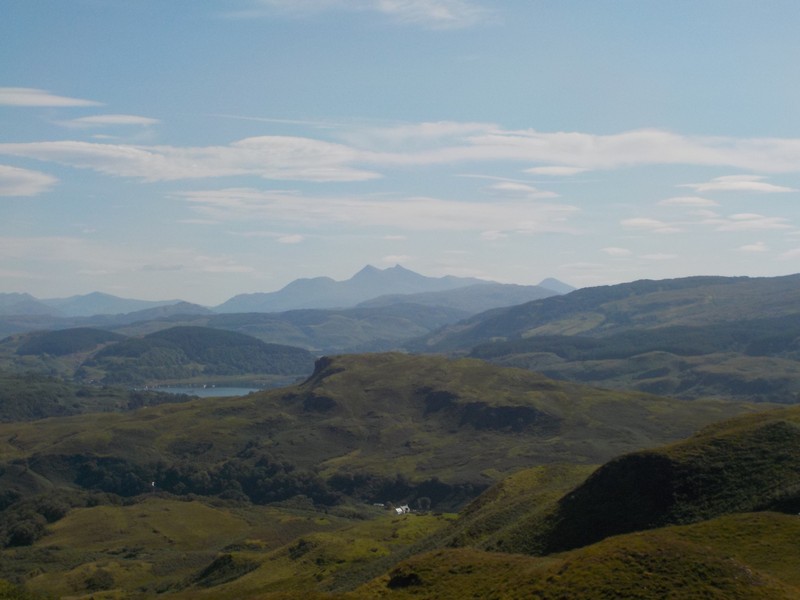
I set off down the B844, but as soon as I reach Clachan farm I turn off west along a good farm track which meanders north and takes me closer to the Marilyn Beinn Mhor (194m), which I intend to climb. I leave the track as it begins to head south again and negotiate a short section of bracken before reaching the trig point at the summit. Although the height is quite modest, the views from the top are magnificent. I look north to pick out the hills of Morvern and Ardgour and the pink scars of the granite quarries at Glensanda, the high tops of Mull are all clear; I can also look down on the Isle of Seil and pick out my route from two weeks ago. Cruach Scarba is still dominant to the south and to the north-east, the Munros of the Ben Cruachan group are all visible. I head due east of the summit making a descent down to the B844 road; the road is busy but vehicle speeds are being kept to a safe limit.
On the summit of Beinn Mhor looking north to Morvern & Ardgour, with Kerrera in the foregroundLooking south over the Isle of Seil, with Cruach Scarba in the distanceLooking North East towards the Ben Cruachan groupHairy friend I met at Kilmore. Scottish Deerhound or Irish Wolfhound? Or even Lurcher?
I arrive at the small hamlet of Kilinver which has a small church and a few houses. I take refuge in the church, seeking shelter from the strong morning sun and thankful for the cool and peaceful place to eat my lunch.
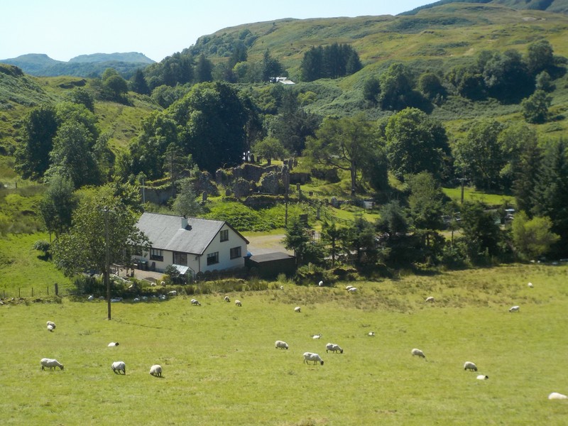
I soon join the A816, which is very busy with speeding motorists. The road hugs the shore of Loch Feochan, which I must walk around the head of. I am fortunate to have trees lining the road to give me shade from the midday sun. I enter Kilmore, another small hamlet with just a few houses, a village hall and a bus stop. Shortly after leaving Kilmore I begin looking for a track that will take me west cross-country to cul-de-sac road at Lerags. I walk over a small hill and look down on the hamlet of Lerags. I can see next to the farm what appears to be a ruined church and graveyard called An Tobar. I meet Liam Griffin, who lives, works and owns the land on which the church and burial ground stand. This is the church of St. Bride the Virgin Lorn and the burial ground of MacDougall chiefs. Liam and the Friends of Kilbride have done a tremendous job in clearing the site, revealing and preserving an important site of historic significance. However, the work is not complete and will require a significant investment hopefully forthcoming from Lottery or Historic Environment Scotland. If you are down that way, the site is well worth a visit.
Looking down on Kilbride Farm with church and burial groundChurch of St Bride the Virgin in Lorn
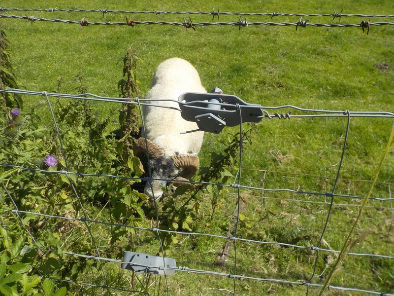
I set off down the road and get no more than 200m before I pass a small herd of Swaledale sheep in a paddock. One of the rams has got its horns well and truly tangled and stuck in some wire fencing. The sheep appears to have been in that position for a while, out in the sun and no access to water. I return to Liam’s farm and ask him who owns the sheep. Liam pops down the road to check the situation out; he meets one of the locals who has a set of bolt-cutters in his truck who quickly jumps over the fence, cuts the wire and releases the sheep. Job done, nothing more to see, move along please!
Entangled Swaledale in fencing
I continued down the road as far as Lerags Farm and turned off the tarmac road onto a farm track. I was trying to cut up the steep hillside, but after a couple of attempts I was getting nowhere; the bracken and the gorse was just too dense. I finally managed to find an old sheep track, which although overgrown with vegetation I managed to force my way through onto the open hillside. I was aiming for a tiny loch, Lochan Tri-Chrioch, at the corner of the forest, which would lead to a bealach and track down to Gallanach Farm. Well at least that was the plan, in actual fact the bracken had totally overgrown any track that was there. I had to beat my way through the head height bracken down over steep ground to a private road which ultimately lead to the public road. The demarcation between both roads was marked by a large locked gate. After carefully searching I was able to find a wooden pedestrian gate that was purposely disguised and hidden behind a large waste bin, which I had to push aside. Obviously, they don’t want people coming onto their land.
Looking north towards ObanTough walking above Gallanach farm
The rest of the walk back to Oban was along the narrow and busy coastal road along the Sound of Kerrara, passing the ferry point for the short journey across to Kerrara and then into Oban.
Approaching Oban
NB: I also publish all my Scottish Blog entries on the excellent Scottish Hills website, I use the same narrative, but larger photos and a few extra ones. They can be found here:
I quickly get a brew going and eat my cereals as the midge are about! I am forced to keep on the move – eating and drinking! I pack up the tent and literally just throw it into the back of the car. I then drive around to the Isle of Seil and park at the Clachan Bridge just opposite the Tigh-an Truish Inn – the house of the trousers. Once a secret meeting place to wear a kilt, when the post-Culloden restrictions were rigorously enforced.
I have 30 minutes before the #418 bus will take me to Kilmore, where I will catch another bus, the #423, which will take further down the A816 to Kilmelford where I finished yesterdays walk. I am pestered by the midge as I wait for the bus, fortunately I am joined by a couple, who get their fair share of attention from the little b*!*ers.
I had removed my gel pad from my left foot as I was having second thoughts on how effective it was on relieving the pressure on the ball of the foot. I found that walking in my North face Hedgehogs was much more comfortable than walking in my boots, which I was carrying in my bag for any off-road rough bits.
Looking down Loch Melfort
I set off from Kilmelford along the very quiet lochside road that runs 5 miles to the farmstead at Degnish. The weather was lovely and warm and sunny. There was little wind with the odd cloud in the sky, which meant the sun was not that fierce. The yachts anchored in the tranquil Loch Melfort provided a beautiful picture postcard image.
Loch Melfort with Cruach Scarba in the distance
Only a couple of cars passed me as I made my way down the road, which rose steeply as i passed onto the Kilchoan Estate. Just short of Degnish I took an upland path that rose steadily over the slopes of Dun Cruitagain. As I gained height, some patchy rain showers arrived, but not heavy enough to warrant putting my jacket on. The upland track was easy walking and the only obstacle was a small herd of Luing cattle with a bull and calves in tow. I carefully made my way around them, but they were not interested in me. At the Bealach Gaoithe, I had a good view of the route ahead. In the immediate foreground I would be passing through the Armaddy Estate, where the terrain looked very complicated with numerous small hills and lumps, hiding quarries long since overgrown. In the far distance I could see Mull, now even closer. I could make out one of the hills I climbed 5 years ago, Dun na Ghaoithe with its long winding ridge leading to radio mast. I could also make out for the first time, across the Firth of Lorne, the hills of Ardgour or more precisely Morvern. To my left I can also see the Isle of Seil across the narrow Sound of Seil. Shortly after leaving the bealach I failed to notice the Wishing Tree, a tree with many coins embedded in it denoting someone’s wish. I must have been concentrating on the route ahead to have missed this.
Looking north over the Armaddy Estate
I make my way through the complex estate roads and eventually arrived on the tarmac estate road that came from Armaddy Castle. I eventually join up with the public road which took me around to the Clachan Bridge. The bridge was designed by John Stevenson (and not Thomas Telford as is sometimes quoted), built in 1793 it is also referred to as the Bridge over the Atlantic. Standing on the bridge it is easy to see how the narrow channel makes Seil an Island.
The Clachan Bridge, Seil IslandThe narrow channel between Mainland and Island
I carry on down the busy B844 carrying traffic to Ellenabeich. When I arrive at the small village of Balvicar I continue straight on taking the road towards the Luing ferry. A car stops and a chap offers me a lift, which I politely decline, explaining I was only going as far as the nearby church and then walking over the slopes of Barr Mor. Looking down from Barr Mor I can see the extraordinary and dramatic landscape that has made this island and others close by so unique. There are known as the Slate Islands and Ellenabeich, where I am heading to was once the centre of a huge slate industry in the early to mid 19th century. I drop down to the road and walk into Ellenabeich. This slate village has certainly embraced its industrial heritage and has become a very popular tourist attraction. It is difficult to see on the ground where all the quarrying took place, until seen from the air as the following YouTube footage shows:-
Looking towards EasdaleHeading towards EllenabeichSlate workers cottages, EllenabeichEllenabeichGift shops and brewery, Ellenabeich
I thought of another centre of slate production, Blaenau Ffestiniog in North Wales and how different the two sites are. I think one of the factors is that the spoil waste has been levelled at Easdale, whereas at Blaenau it is still very much on show.
I had planned to beat my way over rough ground back to the car at Clachan bridge, but because of my sore left foot opted to retrace my steps back along the road.
Distance today = 16.5 miles
Total distance = 2951.5 miles
With the football season fast approaching, an important pre-season friendly on Wednesday prohibited me from making this a 3 day trip. So it was an overnight drive and park up at Kilmelford in order to catch the 9:43 #423 bus to Ardfern. This was a later start than I normally do, mainly because of the school holidays, which meant a restricted service.
Today I was trying out some gel inserts in an attempt to relieve the pain and discomfort on the ball of my left foot. My impression after the first day of wearing these inserts was that I was unsure whether they actually made any difference. Certainly walking in my walking shoes, rather than my boots, helped.
Renovated and converted church in Ardfern
It was a lovely still and sunny morning as I walked down the quiet cul-de-sac road out of Ardfern alongside Loch Craignish. I was shaded part for part of the way by with trees that lined the road. My first port of call was the ruined chapel with 14/15th century carved stones – The Craignish Sculptured Stones. Although there was a partial roof to the ruined chapel housing the stones, the quality of the stones were not as good as those stones I had seen previously at Saddell, Kilmory and Kiels. Most of the stones had a lot of the detail lost.
Giant Butterbur[?] near Craignish CastleAt the entrance to Craignish Castle I met and struck up a conversation with a retired couple, Norah and Chris from Hampshire. It turned out that both Norah and Chris were also walking around the coastline of Great Britain! They were also not that far off completing their journey. They were only the second group of people, ( well third if I include Helfpul-Mammal) that I have met who are walking the whole coast. I spent a good 45 minutes chatting to Norah and Chris, before I moving on.
Craignish Sculptured Stones
I round Craignish Castle, walking along the muddy beach and head for high ground on the west side of the promontory. I have a good view of the castle, which is now converted into apartments and my way further north. I can also see a route ahead, keeping to the higher ground and avoiding the worst of the bog and bracken. Cattle have been roaming through the bracken, which have created a myriad of tracks, although not always in my direction of travel. I drop down into a small bay from Druim an Achanarnaich and I met an elderly gent who seems to be searching the rocky foreshore. This is Tony, a retired commercial mariner, now living in nearby Ardfern. Tony is searching for a special type of whelk which he sends off to a marine biology department for research purposes. I spend almost an hour chatting to Tony about this and that. I tell Tony I’m heading for Gemmil, a farmstead that appears to have a good track running north from it. Tony asks me to send his regards to a lady that lives at the house.
Walking around Craignish CastleLooking across to Cruach Scarba on the Isle of ScarbaCraignish CastleThe route ahead towards Druim an AchanarnaichHeading down to Creag Ban, where I met Tony
I walk across boggy ground just below the large house of Barrackan, heading for high ground again. This rough walking has not been particularly bad; by keeping to the higher ground I have been able to plot my route using sheep, cattle and atv tracks. Although at times I have still had to battle through bog and bracken, but nothing too difficult. Just after rounding the isolated hummock where Dun Ailne was once sited, I could make out Gemmil, about a mile away. I picked up an atv track which took me right past the door of the farmstead. I passed on Tony’s regards to the occupant and continued on a newly driven estate road.
Looking back towards Druim an AchanarnaichLooking NW towards Mull with the islands of Luing and Shuna in the middle distance
I entered onto an extensive area of Lunga Estate roads, which had a large collection of houses. Most of the roads seemed to lead down to the marina at Craobh Haven. The rows of newly built houses at Craobh Haven appear to have been set out as mews/ terraces with the intention of looking like a quaint village. However, they still looked very new and out-of-place. Although the island of Scarba has dominated my view for the last two trips, the hills of Mull have slowly come more into view, becoming larger and more distinctive. I can now see the islands of Luing and Shuna, quite close offshore. After walking down a dirt track for a mile I emerge on the A816 for the walk back to Kilmelford. the walk back along the road is not enjoyable because of the constant verge-hopping.
Craobh Haven
I finally get back to the car and my left foot is particularly sore, but I should be ok for tomorrows walk, which will not involve any main road walking.
Distance today = 15.5 miles
Total distance = 2935 miles