
This section required some thought and planning due to: one, the absence of any footpath for the first 4 miles along the shore of Loch Striven; two, the infrequent bus service from my end destination and three, coordinating the start of the walk at low tide or as near to it as possible.
Essentially, this walk took in one of the many promontories that jut out into the Forth of Clyde, collectively giving rise to the Clyde Sea Lochs.
I had read other “Coasters” accounts of how they had tackled this section, most appeared to have just ignored it, choosing instead to just walk along the B836 bypassing the promontory. I had read only one account by a coastal walker, David Cotton back in 2002, who had undertaken this section, although there may have been more. David described this section as a very tough walk that should be tackled at low tide, if you wanted to walk the shoreline route. I also considered the higher route, possibly taking in the Marilyn Beinn Bhreac (506m) before dropping back down to Troustan House located at the end of the un-pathed section. Unfortunately, the start of this section is heavily forested and I could see no reliable route onto the open hill. ** See footnote.

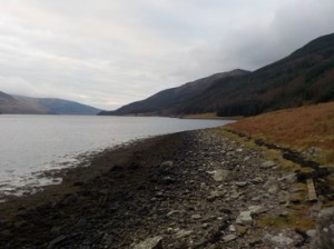

So my plan was to take on the low route along the shoreline, at low tide and leaving my bicycle at the end of the walk in order to provide transport back to the car. Low tide at Loch Striven was occurring at about 5:30 in the morning, but I opted to start at 7:15. I began with a short section of road walking from Ardtaraig to the derelict farm at Craigendive. It was still dark, so I wore my hi-vis vest , strobe head-torch and flashing red rear light. At Craigendive I took to the shoreline and found the going very easy to the ruins at Stiallag, where it seems a recent road had been opened up back to the B836. After Stiallag I encountered the first of many outcrops into the loch which would require me to climb around them. I doubt it would be possible to walk around them along the shoreline, even at low tide. It was really a case then of finding the best route around the outcrops through the trees. I did however, pick up a number of faint deer tracks, which came and went, but still aided in picking a way through the vegetation. However, in spring and summer it would be impossible to follow them due to the amount of bracken underfoot.

And so it continued for almost 2 1/2 hours walking along the shoreline, going up and down around obstacles. There were a few grassy level sections which could provide excellent wild-camping sites. I knew exactly where I was along the shoreline, as I had been paying careful attention on yesterdays walk along the opposite side of Loch Striven to certain features on this side. As I approached the end of the un-pathed section my thoughts turned to Jennifer Thomson who perished close-by in 2007. Eventually I emerged out of the woods near to Troustan House. I must admit it was a bit of a relief to be back on a path. The route had not been easy, but neither had it been unduly hard. From Troustan onwards the walk would be all along the road. So I simply changed from my walking boots to my walking shoes, which I had been carrying in my bag.

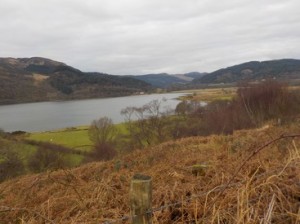
The public road clings to the shore for most of the way and I was soon rounding Strone Point (one of many with a similar name in the area). I had excellent views of Rothesay and Port Bannatyne on the Isle of Bute as I bade goodbye to Loch Striven and entered into the Kyles of Bute. As I rounded Strone Point I suddenly came upon a Sea Otter who was busy feeding on a fish very close to the shore. I managed to get within 20m of him before he noticed me and dived under the water. This was the first time I had seen a Sea Otter in the wild. Unfortunately, my camera did not do full justice to the occasion.


I continued onwards along the road with the Isle of Bute dominating my view ahead. I soon espied the Cal-Mac ferry operating the short 300m across the Kyles to Bute. From the ferry terminal at Colintraive the road suddenly became much wider and turned into the A886. I was not on the main road long before turning left onto a minor road that was probably the old road to the ferry, which twisted and turned but was very quiet. I had now entered into the doubly named Loch Riddon or Loch Ruel. After 2 1/2 miles the old road re-joined the new road. The main road was relatively quiet, punctuated only by a sudden burst of 5 or 6 cars all at once as the Colintraive ferry disgorged its load.
After 6 hours walking I finally arrived at the B836 junction where I had chained my bike to a signpost. The bike ride back to the car was a mixture of push and ride with an exhilarating and swift descent down to the head of Loch Striven.
NB: I also publish all my Scottish Blog entries on the excellent Scottish Hills website, I use the same narrative, but larger photos and a few extra ones. They can be found here:
http://www.scottishhills.com/html/modules.php?name=Forums&file=viewtopic&t=23435
**Footnote: On my bike ride back towards the top of the B836 I noticed a recent area of de-afforestation and could quite clearly see a short but wide fire-break leading to the open hill. An obvious high route alternative to the one I had just completed.
Distance today = 19.5 miles
Total distance = 2588 miles


