39. Porthleven to Lizard

The last day of my three-day walk around the Lizard. Today is going to be a relatively short walk from Porthleven south to the village of Lizard. I would be making use of my moped again, so I intended to first drive to the Lizard, drop off the  moped then drive to Porthleven and walk back.

walk391
Looking back at The Loe

It was an overcast morning when I first set off. I’d manage to find a free car park just on the edge of the village. I follow a tarmac road towards Highburrow where the road ends. I walk alongs a  newly constructed path, due to the many recent landfalls along this stretch of the coast. The path drops down to Loe Bar, a short raised section of beach which holds back the largest  body of freshwater in Cornwall, The Loe.

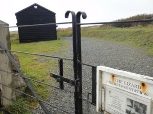
I climb off the beach continuing south-east. I pass a small memorial, with a white cross dedicated to the 100 or so people lost when HMS Anson was beached in a storm in 1807. I continue along a very level path all the way to the hamlet of Winnianton. Here I find the church of St Willwalloe at Gunwalloe. The church is quite an unusual shape and looks to be into the dune system here. I do not pay a visit, but continue. I pass into another small sandy beach with a minor road. The path soon leaves the road and climbs steadily up a gentle rise to a monument. I am just above Poldhu Cove and this is the site of Marconi’s wireless station, the location where the first transatlantic radio message was sent in 1901.

walk392
Gunwalloe Church
walk393
Mullion Cove

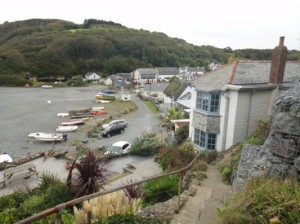
I walk around a former large hotel, now converted into a retirement home. A short distance on, I pass another hotel above Mullion Cove. The coastal rock formation have suddenly become very dramatic, with a number of large sea-stacks guarding the entrance to the Cove. I continue on along grassy paths with little or no elevation. It has become very sunny now and with the absence of wind it feels just like spring. The dramatic coastline continues with rock of many different colours on show. I pass Soap Rock, previously mined/quarried for Soapstone or talc.

walk394
Kynance Cove

At Kynance Cliff I head due east and drop down into Kynance Cove, one of the Cornish ‘honey-spots’. The cafe down by the beach is very busy and there are many people walking along the beach and exploring the various small inlets. I drop down to the beach nad climb up the far side. I pass a number of Choughs, with their distinctive red legs and beak.

At Caerthillian Cove, I reach the point where I had finished yesterdays walk, so I follow a public footpath into Lizard. The walk has taken 3.75hrs.

Distance today = 13 miles
Total distance =   584.5 miles


****

38. Coverack to Lizard

My second day of a 3 day trip to the Lizard. Today would be a tough walk with multiple ascents and descents and the weather would play a part as the walk began in grey, cold, windy and wet conditions.

This part of the Lizard is not covered well by public transport, so it was a case of driving to the Lizard village to park then ride my moped to Coverack where I would begin my walk.

walk381
Coverack

One of the great attractions of the Lizard is its geology and the unique appearance of ophilites and other rarely seen rocks such as Serpentine. Ophiolites are thought to be part of the earths oceanic crust and upper mantle. At Coverack the ancient Moho is visible and was originally sited some 5 to 8km below the oceans and forming the boundary between the Earth’s Crust and the Mantle. I did not search out the ancient Moho, as I suspected I would have to get along along the beach somehow. As the tide was in, this would have not been possible. I continue around Dolor Point and onto Chynhalls Point with its Iron Age Fort.

The Path gradually climbs the Chynhalls Cliffs which lead out to Black Head. Here is an enclosed lookout point, now converted into a small information centre with views all along the coast. Unfortunately, the views are not so good this time of the morning with mist, rain and squalls limiting the views. I do however, get some respite here from the elements before continuing my journey. After another 2 to 3 miles I come to Kennack Sands and it is here that Serpentine is seen in pebbles, cobbles and boulders of various sizes on the beach. This metamorphic rock has beautiful colouring with reds and greens showing up when the rock is polished or wetted. I carry a few samples home with me to lacquer and preserve the striking colours.

walk382
Cadgwith
walk383
Devils Frying Pan

I press on passing through the small fishing village of Cadgwith and a little distance on I pass a large collapsed sea cave with its sea-arch still visible – this is the popularly named Devil’s Frying Pan. At Kilcobben Cove I pass above the recently (2011) resited Lifeboat station with its impressive funicular lift down the steep cliff face to the station itself. I pass the Bass Point with its large look-out station and begin to walk westwards.

walk384
The Lizard lifeboat station

In the near distance I can see a large white building housing the Lloyds Signal Station where incoming vessels were given orders through semaphore about their movements. About 100m further on I pass the restored Lizard Wireless Station, now owned by the National Trust and where Marconi did a lot of his pioneering work on wireless telegraphy in the wooden shack.

walk385
Lloyds Signal Station
walk386
Lizard Wireless station

I head towards and around the Lizard Lighthouse and thence to the Lizard itself, with a visitors shop and car park. I pass a number of visitors who seem to have appeared along with the sun. Although strictly speaking this is not the actual Lizard Point, it seems to be the popular choice. The actual Lizard Point is about 400m west of the popular choice. I head around the Lizard and begin walking north. When I reach Caerthillian Cove I head in land along a public footpath into Lizard village and the end of my walk. It has taken 5 hrs.


walk387
Looking back to “Lizard Point” from the actual Lizard’s Point


Distance today = 13 miles
Total distance =   571.5 miles


37. Coverack to Helford

Today was going to be the first day of a three-day trip to walk around the Lizard Peninsula. I was basing myself in the small village of St Keverne, at the Three Tuns Inn. St Keverne is a quiet little village not far from the sea. The village was very prominent in 1898 when 106 poeople onboard the liner Mohegan lost their lives when the ship struck the infamous Manacles reef. Most of the unfortunate victims of the disaster were buried in a mass grave in St Keverne.

The Lizard is not that well served by public transport so I load my moped into the Doblo van. The first port of call was Helford where I dropped the moped off. It was free to park my moped here. I then drove to Coverack, I also found free parking for the Doblo as well in a small local car park with sweeping views up the Lizard coast.

walk371
Sign at Porthallow or Pr’alla

The walking for the first couple of miles was very easy-going. I passed the now disused Dean quarries, which used to quarry for Gabbro. There is still extensive quarrying on this section of the coast, and even though this quarry was now closed other quarries remained in use and would account for two major detours inland to get around them. Upon reaching Godrevy Cove the path headed inland on the first of the detours through the small hamlet of Rosenithon and then back towards the

walk372
The village of Porthallow or Pr’alla

coast at Porthoustock. The second detour from Porthoustock pointed back inland again for over a mile before I dropped down again to the coast and the small village of Porthallow (pronounced Pr’alla locally). The local pub, The Five Pilchards was still closed, but I was amused to see a sign with an elective range of names associated with the village.

walk373
Damaged road at Gillan Creek
walk374
View across the Helford to Helford Passage
walk375
The village of Helford
walk376
The Shipwrights Arms in Helford

I climb above the cliff-line and continue walking north towards Nare Head over open fields. In the distance I can now make out part of Falmouth. I head inland following the course of the Gillan Creek. At low tide it is/ or was possible to cross the  Creek at Low tide, but crossing is now not advised. Anyway, I could not see a way across without getting my feet wet. So it’s a 2.5mile detour to get around the creek. The going is easy and as I round the head of Gillan Creek I continue along a narrow road. The road has suffered some damage with recent floods and is closed to traffic, but not for those on foot. I pass through the small village of St. Anthony-in-Meneage and walk out towards Dennis Head. The view is quite extensive now out across the mouth of the Helford River towards Falmouth. The final two miles into Helford is along the banks of the Helford and through trees. I eventually emerge into the picturesque village of Helford with it’s lovely cottages and thatched roof pub, the Shipwrights Arms. The walk has taken 5 hours. I ride my moped back to Coverack to pick up the van.


Distance today = 13 miles
Total distance =   558.5 miles