343. Dymchurch to Dover

I decided to reverse the direction of travel for today’s walk because of bus times, so I drove to and parked again at the Western Heights car park. I read some signs saying that the car park had been the centre of recent anti-social behaviour, although given the shifty nature of the people I saw in parked cars that early in the morning I have my suspicions what that could be! I Again I descended down towards the Railway Station, but stopped short at a bus stop and waited for the 07:51 #102 service towards Lydd. The bus journey seemed to take an age as the driver observed strict timetable waits at a number of stops.

I was glad to get off the bus in Dymchurch and equally pleased to have used my OS App, with free Bus Wi-Fi, to know which stop to get off. A short walk saw me on the large and sweeping shoreline of East Road. The bay curved back towards Folkestone and had a large modern sea wall guarding the low lying interior of Romney Marsh. I passed by a Martello Tower that had been totally transformed into a residential property with the walls all rendered and a large conservatory on the roof. When I reached the Hythe firing ranges I could have continued along the coast because there was no firing planned for today. However, I could see a large construction site around the Dymchurch Redoubt, complete with Heras fencing. I decided to stick to the perimeter road around the firing range.

As I entered Hythe town itself I was interested to walk along the Military canal; built between 1805 and 1809 as a strategic move against a possible French invasion during the Napoleonic Wars. The canal runs for 28 miles from Hastings to near Folkestone. I followed the canal till it came very close to the promenade which ran  all the way into Folkestone. The sea front was busy with many people out walking, cycling, jogging and just chilling out at the number of beach side cafes.

Looking towards Hythe and Folkestone from Dymchurch
Transformed Martello Tower at Dymchurch
Dymchurch Redoubt
At the Military Canal in Hythe with statues of Navies who dug the canal
The Military Canal in Hythe
Heading along the seafront towards Folkestone
Sandgate Castle was the first of Henry VIII’s ‘Device Forts’, basically an Artillery Fort
Folkestone Harbour

As I reached Folkestone I passed by the old Folkestone Harbour railway station, closed to all traffic in 2009, in 2018 after a period of refurbishment it re-opened for pedestrian use and was hosting a small open-air market when I was there. I crossed over the old railway bridge and along the harbour walls with its fish sellers doing a brisk business. At Copt Point I climbed up steep steps towards the Martello Tower, which offered excellent views ahead across the expanse of wild partly forested chalk cliffs called The Warren. Here the Saxon Shore Way and England Coast Path joined the North Downs National Trail. I could have descended and walked along the base of the cliffs, but at some point I would need to climb up onto the cliff. I chose to do the climbing first as I planned to visit somewhere that was situated on the cliff-top path.

I had caught a glimpse of the Battle of Britain Memorial earlier that morning on the bus, so I was keen to take a closer look. Opened in 1993 on the site of the Capel Hill Battery (WWII), the Battle of Britain memorial contains a visitor centre, which was closed and a replica Spitfire and Hurricane. The open area contains a wall listing all those that fought in the Battle of Britain. Both yesterday and today a Spitfire flew over Dover and Folkestone performing aerial manoeuvres, I’m not sure if that was a planned thing, but it certainly brought home the message and the debt the county owes to “the few”.

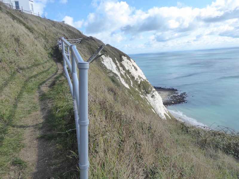
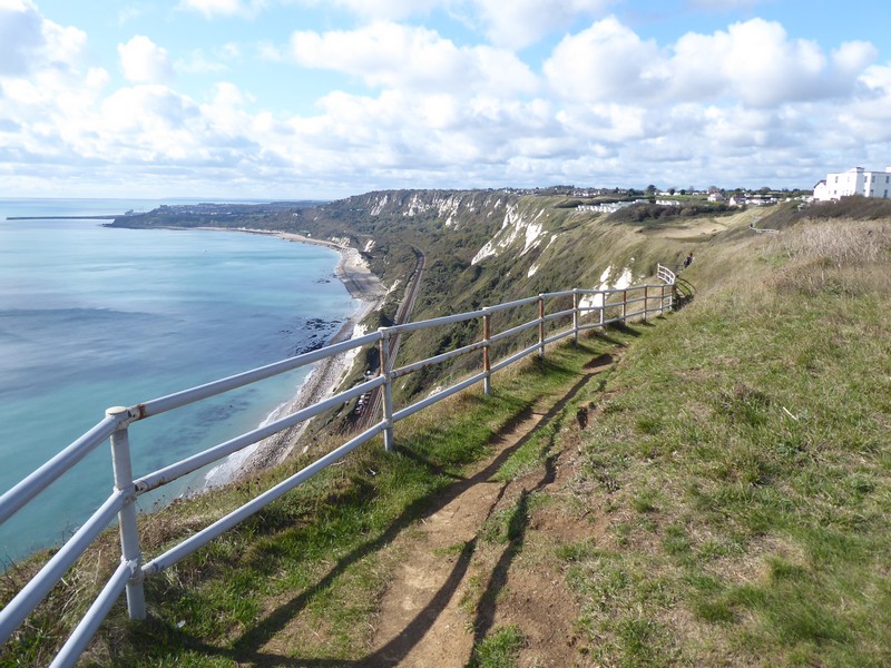
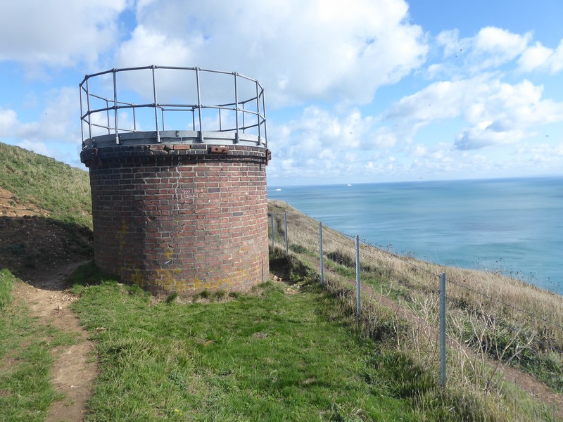
I continued on across the Warren cliff top towards Abbots Cliff, here the coastal path split to a minor inland incursion avoiding the narrow path with exposed drops down to the railway line. Soon after I came to the Abbots Cliff Sound Mirror. A forerunner of radar, acoustic mirrors were built on the south and northeast coasts of England between about 1916 and the 1930s. The ‘listening ears’ were intended to provide early warning of incoming enemy aircraft.

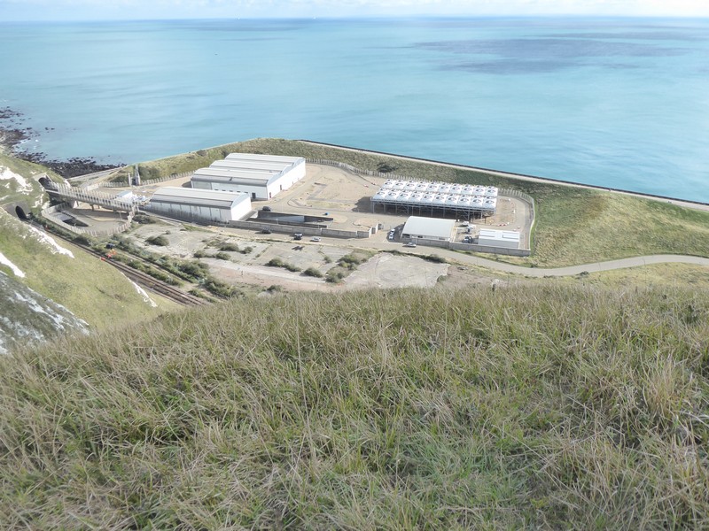
The amazing physical features as I began the descent towards Dover were the ‘hogs-back’ chalk cliffs with grassy slopes and a narrow arête like ridge. At this point I could look down onto the Samphire Hoe Country Park, hemmed in by chalk cliffs and the sea it is an unusual site. Part of this area was created in the mid-19th century to enable the Folkestone – Dover railway to pass through. The real major construction project occurred with the building of the Channel Tunnel in 1993. Closeby the Channel Tunnel at some depth below the ground turns seaward heading out across the Channel. The spoil from the tunnel was used to create Samphire Hoe with landscaping to create a Nature Reserve. Access to the Hoe is via a tunnel from the nearby A20, with cars passing through the 200 -300m tunnel governed by traffic lights, a raised footpath allows pedestrians and cyclists to pass through to the Hoe. At the far end of the Samphire is a collection of buildings and a large cooling plant for the Tunnel itself.

I climbed up and over Round Down and descended to cross over the A20 to the small village of Aycliff on the outskirts of Dover. Here I found a shop open and stocked up on drinks for the drive home. I now had the task of climbing up from sea level to the top of Western Heights. Near to the car park I passed an early 12th century church built by Knights Templar.

A thoroughly enjoyable and fascinating walk.

The old renovated Folkestone Harbour Rail station
Crossing the old Harbour rail bridge
Looking back at Folkestone Harbour
Heading towards The Warren
Looking back over Folkestone from the top of The Warren
Looking across The Warren with the Folkestone – Dover rail line emerging from a tunnel
Hawker Hurricanne replica at The Battle of Britain Memorial
The wall of names of those that fought in The Battle of Britain
Statue of airman at The Battle of Britain Memorial
Looking back along The Warren towards Folkestone
Precipitous path above Abbots Cliff
Looking back from Abbots Cliff
Sound Mirror above Abbots Cliff
Ventilation shaft for the Folkestone – Dover railway
Looking down on Samphire Hoe
Looking towards Dover along the hog’s back chalk cliffs on Round Down
Chalk cliffs above Samphire Hoe
Looking down on Samphire Hoe at the Folkestone – Dover railway and the buildings and cooling plant for the Channel Tunnel
Zoomed shot across the Channel to Calais – just visible
Heading down towards the A20 and Aycliff
Fields are easy visible in this zoomed shot across the Channel
Dropping down off Round Down, a line of 3 shafts can be seen supplying ventilation to the Folkestone – Dover railway
The access tunnel to Samphire Hoe
The Knights Templar Church on Western Heights

Distance today = 18 miles
Total distance = 6,372 miles


342. Sandwich to Dover


It was the last days of July when I was last in Kent, while in the intervening time the pressing business of completing the Scottish section of my walk had kept me busy.

With rising Covid cases across the country I am convinced it is only a matter of time before I am forced into lock-down either locally or prohibited to travel to the Kent and Sussex areas. Besides the worries about the pandemic, I have also had one eye on the Brexit trade deal situation, with plans being drawn up to counter the predicted queues around the ferry ports of Dover and Folkestone. It’s an area that I want to get as far away from as possible before the inevitable turmoil starts in January.

There was good news in that I only had to travel 247 miles down to Dover and with each completed section I will move closer to home. Another good sign is that I am now travelling south along the M40 and M25 having finished with the Dartford Crossing.

The drive down from Shropshire was uneventful and by 6:45 I was parking up at the observation car park on Western Heights above Dover. The view from the car park was amazing, with the dawn light just appearing I could pick out Calais and Dunkirk across the Channel. To get to the start of today’s walk at Sandwich, I needed to descend into Dover and make my way to Dover Priory railway station.

Most of today’s walk would be mostly on the level, although towards the end there would be a few up and downs. After leaving Sandwich railway station I walked through residential streets  towards Sandwich Haven River and the River Stour. I could have made things very easy when I joined the England Coast Path by simply walking across the golf course to the sea which would have saved about 3 miles. Instead I followed the river northwards along a levee or sea bank. I did eventually turn around and start walking south when I joined the sea and began walking alongside 3 golf courses, the most famous of which was Royal St. Georges, which occasionally hosts The Open.

Early morning at Western Heights above Dover Harbour looking across the Channel to the lights of Calais and Dunkirk
The River Stour near Sandwich
Heading north along the River Stour near Sandwich
Looking across Pegwell Bay to Ramsgate
Heading south along the shoreline
Building up sea defences near Deal

I eventually made my way into the seaside town of Deal. I decided to walk through the town itself, which was really very busy, as I struggled to socially distance myself at times, picking my way through the Saturday afternoon shoppers. I passed Deal Castle which I did not think much of, until I read the castle was actually built under the orders of Henry VIII as an artillery castle, a similar fortification to the ubiquitous Martello Towers, often seen in this part of England. By the time I reached the adjacent town of Walmer, the crowds had thinned out and the White Cliffs of Dover made an appearance.

The weather so far had been very nice with a warm breeze and excellent visibility, particularly across the Channel to France, where I could see a constant stream of ferries going back and forth. After passing through St. Margaret’s at Cliffe I arrived at the South Foreland lighthouse and the arrival of more crowds of people walking out from Dover itself.
I tried to stay on a level contour over the down land terrain and after passing around Langdon Hole I emerged high above the Dover Ferry Terminal. The terminal was very noisy and extremely busy with hundreds of articulated making their way to and from the ferries. On top of the white cliffs there was a number of footpaths available, unfortunately I chose a wide path that was well trodden and dropped down towards the terminal entrance, after losing a great deal of height I was faced with a sign saying this was a dead end. Grrrr! I climbed back up the cliffs and found the correct path and dropped down to the A20 road beside the ferry terminal. I continued along the shoreline of the Outer Harbour and passed a number of statues and memorials, dedicated to the role of certain armed services during the Second World War. There was also a memorial to  Captain Matthew Web, who hailed from Dawley (now in Telford) where I was born and still live. In fact there is a pub 400m from my home called the Captain Webb.

In Dover I passed by an M&S Food Hall where I hoped to buy some food, however, there was a long queue outside so I did not bother, instead settling for a pasty and coffee from a local Greggs. I continued through Dover town centre and climbed uphill to the Drop Redoubt along the North Military Road.

This whole area of the Kent coastline is steeped in history and you would need a few days to explore it fully. All that remained for me to do was drive the 4 miles to my Premier Inn bed for the night.

A very busy Deal High Street
Deal Castle
The appearance of the White Cliffs near Kingsdown
Looking back towards Deal
Looking back northwards near St. Margarets at Cliffe
The War Memorial at Bockell Hill
Looking down to St Margarets Bay at St. Margarets at Cliffe
Zoomed shot across the Channel to France with fields and the beach visible
A ferry departiing Dover bound for France
The harbour and ferry terminal at Dover
Looking down on the Dover ferry terminal
Approaching the end of the “dead end” path!
Dropping down into Dover
Passing under one of the main approach roads to the ferry terminal
The White Cliffs of Dover
Memorial to Captain Matthew Webb, the first person to swim the Channel
Another zoomed shot across the Channel with white cliffs now visible

Distance today = 21 miles
Total distance = 6,354 miles