I thought it would be a good idea to have a visual representation of my progress to date in walking the coast of Great Britain. This is basically just a Google map of Great Britain with a red line indicating my progress, its rather crude, but does the job.
Today would be my last trip down to the south west for some time, as this was the final trip to ensure I have a continuous and unbroken clockwise link from Poole to Chester.
The marina at Portbury Wharf
I opted to park close to the M48 bridge in Chepstow, from where I would catch the #X7 bus to Bristol. I opted for the £7.50 day rover which would cover me also for the bus out to Portishead on the # X2. It had taken about 1hr 40 minutes to get to my start point and I was itching to get walking, on what was a beautiful sunny morning.
Picasso-like sculpture at Portbury Wharf
Starting at the Windmill Inn I headed off towards Portishead Point. The familiar view out across the Severn Estuary was even better this morning, especially as the haze had disappeared. I headed east through East Wood along a lovely quiet road before emerging close to The Royal, a pub close to the old disused Portishead Pier.
Disused railway track at Avonmouth
This whole area has been developed with swanky looking apartments overlooking the large marina. I could see the Severn Crossing in the distance as well as the Portbury and Avonmouth Docks which I had to walk around. I made use of the lock gates in the marina to cross over the water.
On the Avonmouth Bridge
At Portbury Wharf I had a nice wak on the levee for half- a mile, before I had to head south towards the small hamlet of thatched cottages at Sheepway. I picked up the National cycleway No. 26 at Sheepway which ran around the periphery of the huge car storage parks that I had seen many times from up high on the Avonmouth Bridge. The scale of the these car storage parks are truly amazing.
Has anybody seen John?
I passed Toyota, Lexus, Mitsubishi, Jeep and Fiat by their thousand. The cycle path soon joined and followed an old disused railway track. It was strange seeing the weeds growing up through the still intact tracks. Some sections of track had simply had hardcore dumped over the tracks and compacted down. The increasing noise had told me I was approaching the M5 and the Avonmouth Bridge. Having travelled over this bridge scores of times in a car, I was really looking foward to crossing over by foot. I was rewarded with some amazing views, that had been difficult to appreciate while driving.
The New Severn Crossing
The next 5 miles was simply a case of following the main roads though the Avonmouth Docks area towards the Seabank Power Station. Close to a newly built business park I was relieved to cross onto the Severn Way, which followed the railway most of the way to Severn Beach. The path was reasonably well trodden, but I appreciated being away from the incessant traffic that had accompanied me for the last 10 miles. The Severn way path crossed over the rail tracks and proceeded towards Severn Beach, where it followed a concrete sea wall all way to and underneath the M4 bridge.
Toll area on the M48 Bridge
The final stretch of path out towards the old Severn Crossing was along Northwick Wharf, a sort of salt marsh and grassy meadow that was very comfortable to walk along. I joined a small road which takes me to the small hamlet of Old Passage. The road begins to rise up to about 30m to enable the bridge to have a degree of elevation.
On the M48 Old Severn Bridge
A service road to the Bridge Toll area also serves as a cycle way. The Bridge toll bays have a gantry, which enables walkers and cyclists to cross over the motorway and walk on either side of the bridge. There is also a service area on the NE side. I opt walk on the SW side, which offers great views downstream to the new Severn Crossing. My view back to Portishead is obscured by a series of short sharp squalls, which fortunately missed me! I was really looking forward to crossing the bridge and it did not disappoint.
Small shooting range on Beachley Point
The odd cyclist passes me, but even surprisingly even the traffic is quite light on the bridge. The bridge makes landfall on the spit of land called Beachley Point, although still still in Gloucestershire, the area below the bridge has a number of military functions, including a barracks, shooting range and sports facilities. The cycle way drops down from the motorway and joins up with the Wales Coast Path and the section I had previously walked. I managed the 19 miles in 5.25 hrs.
Distance today = 19 miles
Total distance = 1655 miles
It was a glorious spring day, with the bulbs in bloom and the sun shining. This was to be my last section of the WCP and I was looking forward to it.
Starting out at Seawall
I drove to and parked at Chepstow railway station. I then caught the 6:19 train to Newport. I walked to the bus station and waited for the #63 to Whitson and the Wetlands. The 63 service is a Demand Responsive Transport service, but they still retain two scheduled services a day. I was catching the 7:30 one. Unfortunately, Newport bus station is also a very busy terminous with no central announcements or timetable. So I had to continually monitor the incoming buses to locate the #63. I only had one chance to catch this bus, so it was important I did not miss it. Anyway I managed to locate, even though my bus had come into a random stand with the words “Not in Service” on its display panel. The bus was very busy carrying workers out to their jobs around Spytty Park. By the time the bus got to Whitson I was the only passenger. I then had to walk about half- a mile down the road to Seawall, to resume the path.
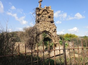
Holy Trinity Chapel at Sudbrook
I had great views across the Severn Estuary to wards Avonmouth as well as towards the Second Severn crossing bridge. The ground was dry and flat and I made swift progress along the path. I decided that I would not gamble on finding the firing range closed and opted to take the short inland diversion. The din from the M4 was incessant and a constant companion for the next 3 miles.
King Tewdrig carving at Mathern
By the time I passed underneath the M4 for the last time and rounded Sudbrook, the look and feel of the Path changed with the coast appearing to give way to an estuary. Sudbrook is famous for the historical attempt to tunnel underneath the Severn. Today, the railway passes underneath Sudbrook, but has its entry point some two miles to the west. I take a while to explore the 12th century Holy Trinity chapel, in ruins since 1720. Parts of the chapel and graveyard have been lost to the action of the sea over time.
Entering the town walls at Chepstow
The first Severn Bridge comes into view, the M48. I follow a short section of seawall and cross the railway as I head inland. This will be my last coast section, as when the path emerges later on it will alongside the banks of the River Wye. I head towards the quiet village of Mathern, although, there is still the hum of the distant motorway. As I pass by the church in Mathern, I notice an elaborately carved figure of the Celtic King of Gwent – Tewdrig. The story goes that Tewdrig was mortally wounded in a battle with the Saxons. As he was being carried to be buried on Flat Holm island, he died where the Church now stands.
The elegant Old Wye Bridge at Chepstow
The final three miles is spent walking around distribution warehouses, motorways and the mundane suburbia of Chepstow. Nevertheless Chepstow is a lovely little market town, with dramatic cliffs as the River Wye cuts its way through to the Severn Estuary. The Start/ End of the Wales Coast path is at the elegantly styled Old Wye Bridge or Town Bridge that links Wales to England. The bridge is now 200 years old. Previously the site of a wooden bridge and ferry point during Roman times, this place is a fitting place to end my walk.
Mosaic of the Coastal Path and Offa’s Dyke
I peruse the various sculptures and signs in the nearby “The Backs” and walk across the bridge into Gloucestershire. One particular feature catches my eye. It is a sort of mosaic which links the nearby Offa’s Dyke with the WCP and an association of various counties, walks and birds, It is really well done
Where England and Wales meet
In retrospect I have thoroughly enjoyed walking the Wales Coast Path and although my challenge has changed en route to include the whole of the coast of Great Britain; it would not have been right not include the small section at Chepstow. I have found the WCP to be, in the main, very well signposted (probably better than the SWCP!), well served by bus and trains and offering a stunning variety of wildlife and scenery.
Now I must link up the end of the SWCP at Minehead with Chepstow.
Distance today = 18 miles
Total distance = 1545 miles
Today was going to be my penultimate section of the WCP. It had taken abit of planning to get the mileages right, so my final day would not be a “gut-buster” . I opted for a place near Whitson, called Seawall. I managed to find a free parking space and walked the half- a mile back up the road to Whitson and the bus stop. This area of Newport is served by what is known as Demand Responsive Transport. What this means is you call them up and agree a time and pick-up spot and they send a car. You have to give them your name and address, so I’m not too sure how that works with tourists etc… Anyway they have retained two scheduled buses a day, so I caught the #63 at 8:00 to Newport, it was then a case of getting the Cardiff train, then catching another bus , the #11 out to Pengam Green. After all this kerfuffle, i did not start walking until 10:00. The weather was beutiful and sunny and with reasonably good visibility. I soon got the heavy traffic and industrial areas behind me and proceeded along the large straight dyke or seawall.
Tawney Owl
A few miles along the seawall, I noticed an owl perched on a fence post, about 20 meters away. It was being pestered by a single crow, but held its ground. I had never so close to an owl in the wild before. It did the ‘swivel-neck’ on me to check who I was. (Checking my RSPB guidebook the owl looks to be a Tawney owl, as opposed to a Short-eared Owl).
I pushed on towards Newport. I notice how the far shoreline across the Bristol Channel of Somerset and Bristol/Avon is getting closer now. I can pick out individual houses and occasionally I get a sunlight reflection from a car mirror on the far bank. I press on and pass West Usk Lighthouse, now a B&B. I notice a Rolls Royce parked in the drive. Hmmm….
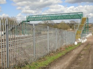
New WCP footpath bridge over railway
As the path moves inland, I see that the road as been diverted because a bridge that previously went over the railway has been demolished. The WCP footpath, however, has its very own footbridge over the railway now.
The WCP signage around this area gets a little crazy, some stupid pointers. I pass some retail shops and pop into Lidl for a couple of bakery items. I am looking forward to going over the Transporter.
The Newport Transporter Bridge
The bridge is open from 10 – 16:00 and is the main reason I decided to walk in this direction. The bridge is one of only 3 in this country and I think together with Middlesborough is the only other working bridge in the UK. I opt to walk over the top and get charged £3 – a bit steep if you consider that to ride in the gondola would have only cost £1. I get a brief safety talk and am then allowed to climb to the top and walk across. Even though there was little wind, I felt a very slight swaying in the structure. The views were well worth it. I descend and then continue walking through the industrial suburbs. I walk around the Wetlands and continue past the “stumpy” little sister lighthouse of East Usk (which is still operational).
Up top on the Transporter Bridge
By now my feet are quite sore and painful. I wish I had brought a change of foot ware, as I had reverted back to boots for this section. I passed through Goldcliffe after which the path headed back to the coast at Seawall ( close to Whitson). The walking had been tough, due to sore feet , but memorable because of the owl and the transporter bridge.
Distance today = 20 miles
Total distance = 1527 miles
With 58 miles to go to the end of the WCP, I looked at the logistics of getting this done with three more trips. I therefore decided to do a fairly short day of 16 miles, which would take me to the east of Cardiff. My daughter Nicola accompanied me on this walk, although I failed to mention to her that it was 16 miles!
The walk alongside Cardiff Bay
The sun was well and truly up as we parked near to the Tesco store in Pengam Moors. A #11 bus, which would take us into city centre, arrived within 30 seconds of us standing at the bus stop. We alighted from the bus slightly early to have a quick look at the Castle and the Millenium Stadium. The Millenium (or Principality as it now) is an amazing building, crammed tight into a space right in the city centre. We caught one of the frequent trains to Barry, where we started walking 25 minutes after starting out. The first 3 miles or so where alongside a road and through mainly industrial parts of Barry.
The Norwegian Church
We eventually emerged on the coastal path as we passed through Sully. The path was straight, flat and dry. Good views were had across the Bristol Channel towards Weston-Super Mare. After rounding Lavernock Point we encountered increasing numbers of walkers who were coming from the direction of Penarth. As we entered Penarth, the crowds were out in force on this glorious Easter Bank Holiday. As we climbed through the town, we were rewarded with a great view across the Bristol Channel and back down to Penarth.
War memorial statue – beautiful!!
We descended over the hill down towards Cardiff, where we had great views down to Cardiff. The Cardiff Bay barrage was an amazing piece of engineering. It was an incredible sight seeing the height of Cardiff Bay some 7m or 8m higher than the receded tide mud flats of the Bristol Channel. The whole area was alive and busy with people. We passed the Dr Who exhibition, the Norwegian Church and some incredible statues. I particularly liked the War Memorial statue of a face carved into the bow of a ship – simply amazing. I also thought the Welsh assembly building and Wales Millenium Centre was brilliant with its purple and green slate brickwork and the champagne-coloured stainless steel cladding was very striking. I must look up the meaning of the words “In these stones horizons sing”, which was emblazoned across the building.
Wales Millenium Centre
The walk out of Cardiff was tedious and we both started to flag abit. we agreed that a cup of coffee would be nice, but could see nothing in sight, then not more 30 metres away Nic spotted a Greggs!! Result. A cup of Coffeee and pastry slice for £2 was fantastic value. We sat in a nearby bus shelter and ate our lunch. We were joined by a gentleman, who was also walking the WCP and we talked for a while about the Path.
Dockside crane at Atlantic Wharf – relic of years gone by
The last mile or so close to the Tesco store is best forgotten. As we passed close to a permanent Travellers site, the rubbish and fly-tipping was probably the worst I have ever seen. I have seen cleaner cleaner council tips!! The rubbish and filth was not restricted to outside of the site, but inside the site rubbish, refuse and scrap was piled sky high. I have walked past other Traveller sites and most are clean and well kept. This site however, was truly appalling – disgusting even!
Colourful roundabout
Despite the end of our walk, I really enjoyed walking through Cardiff. The Bay area was a delight and a place where I would like to go back to.
We managed 5.5 hrs for the 16 miles.
note: because of the wonderful things to see I found it very difficult to limit myself to showing only 4 photos, so I have done 6 instead!!
Distance today = 16 miles
Total distance = 1507 miles
Today was going to be a very early start, as the bus times meant a late start; I therefore decided to drive to Barry rail station where I parked and begin walking straight away. Withe the sun now rising at just after 6 in the morning, I started walking at 5:55!! I like walking very early in the morning because its generally cool and quiet. It was quite light at this time, but a bit nippy.
Sunrise over the Bristol Channel from Barry Island
The rather tedious task of walking around Barry Island was my first objective. I managed to capture a photo of the sun rising over the Bristol Channel, it looked really beautiful. Not so Barry Island though, as within 30 minutes I had stepped in dog crap twice! Barry Island is certainly an oddity, a nice residential area but the theme park stuff with rides etc, do look out of place. As I crossed back over the harbour road I could see my next objective Cold Knap Point. The suburbs of Barry eventually disappeared as Rhoose Point (southermost point of mainland Wales) came very quickly. Here you could see at close hand, from the previous extensive quarrying, the beautifully bedded limestone strata that would be pervasive for the rest of the walk.
Alternative fuel source at Aberthaw coal Power Station
After passing through a poorly signed holiday park, I eventually picked up the path again which soon dropped down to the West House Beach. I then followed a sea wall which shepherded me around the periphery of the Aberthaw Power Station. After the power station I noted the WCP went inland on a bit of a detour – I opted to walk across the beach and pick the path back up after 2km – unsure why this detour is there?
I had good views to the north where Llanwit Major could be seen, about a kilometer away. After dropping down to Cwm Col-huw I decided to walk along the beach as far as St. Donats.
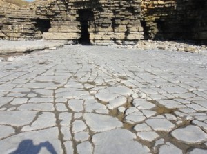
This Limestone Pavement was like a billiard table
The walking was easy on the Limestone “Pavement” with it’s classically weathered surface of “Clints” & “Grikes”. I had a brief look into the Boarding school at St. Donats and then climbed up through a wooded area to be greeted with the Nash Lighthouse and cottages. Walking along the cliff top was a delight, not only because the terrain was level, but it was also dry with the lack of rain over the previous 2 weeks. At Cwm Nash I decided to walk along the beach again all the way to Dunraven Park.
Looking down on Dunraven Bay
I had a slightly steep climb up and down into Dunraven Bay, which had a few people taking the mid-day sun. My walk concluded at Dunraven Bay, but I needed to continue up the road into Southerndown, where I caught the #303 bus back to Barry at a cost of £4.80. My previous concerns about the reliability of this service were ill-founded as the bus appeared bang on time, but not before I was able to down a quick pint of Doom Bar in the 3 Golden Cups. A lovely day of walking with limited hazy views but a number of interesting things along the way. My time of 6.75hrs for the 23 miles was probably down to the beach walking and the level terrain.
Distance today = 23 miles
Total distance = 1491 miles
With the high pressure still clinging to the UK, I thought I would take advantage for another quick stint on the WCP. The forecast had been for overcast and cloudy skies for the majority of the UK, but for the west sunshine was forecast – and they were right albeit a bit hazy. This section required that I get two buses, I decided to reverse my route due to bus timetables. So I parked at Margam again and caught the 6:42 #X1 to Bridgend at a cost of £5. I then then had a bit of a scare with the #303 (cost £2.45) being 25 mins late, apparently it happens a few times, which is a bit worrying as I will need to use this service again. I got off at Southerndown and walked down the beach road to Dunraven Bay.
Looking towards Ogmore-on-Sea on a glorious morning
The walk back past Ogmore-on-Sea was a delight with the crisp morning air from the overnight frost, the soft short grass underfoot and the warm hazy sun. I had a quick look at the beach outflow of the Ogmore River and decided I could probably wade that, if I did not mind getting my boots wet. As I wasn’t wearing boots I opted for the drier option and proceeded on the inland diversion.
Stepping stones at Ogmore Castle
I did manage to get across the stepping stones at Ogmore castle. A few of the stones were slightly below the water and a couple had green (slippery) algae clinging to them. Using my walking stick as a support I managed to get across without my pride damaged. Actually, the stepping stones offer virtually no advantage from the official path a few yards up the road. As I left the village of Merthy Mawr I heard a couple of woodpeckers and and finally managed to catch sight of the pair, they appeared to be Greater Spotted Woodpeckers, but I am no expert.
Steelworks rising above the dunes
I passed through Merthy Mawr warren and onto the beach, which followed around to Porthcawl. The sea front of Porthcawl was quite busy with strollers, walkers, joggers and just people enjoying the early morning sun outside of cafes and tea rooms. The path continued out of town towards the Royal Porthcawl Golf Club, where many golfers were out on the Links trying to improve their handicap. But the most popular activity seemed to be surfing, with literally hundreds of surfers all along the beach for more than a mile. However, the sea and waves were quite benign with only smallish waves. The walk through Kenfig Burrows was quite impressive, particularly with the size of the Nature Reserve, it was massive and somewhat disorientating if you lost your bearings. I had no problem with any floods and could easily circumvent any of the minor pools. Unfortunately, I had little in the way of views due to the hazy conditions, but with Tata Steel works getting closer I knew I was back to the outskirts of Margam.
Derelict marshaling yard at Margam Moors
I passed an overgrown and derelict marshalling yard for the steel works, before I re-joined the main road leading into Margam. I managed the walk in 5.25hrs for the 19 miles.
Distance today = 19 miles
Total distance = 1468 miles
High pressure over the UK for most of the week meant it would have been remiss not to take advantage. So it was an early start from Shropshire to drive to Margam, just outside Port Talbot, and catch the 7:15 #X1 to Swansea. I gulped at the £5 charge, but upon examining my ticket I could see that the ticket was a Swansea Bay Adult Day Traveller, which meant that the onward bus to Oystermouth was covered by the ticket. Perhaps that were I went wrong last week when I complained about the high prices – I should have bought a day traveller ticket type.
The type of terrain for most of the walk
I got off at Oystermouth and literally launched into my walk. This was to be a trainer day, with a light rucksack as well. If I needed additional water then I would simply buy. The path followed the road and shoreline right around in a big sweep towards Swansea. The day was a beautiful sunny day with a nice sharp, but gentle breeze. I was joined by a multitude of people jogging, cycling, walking – mainly doggies and people going to work. I was making excellent time (finished in 5.25hrs) and loafing around is something I rarely do, so I do miss some things sometimes.
Used gym equipment exhibited as beach sculpture
But I did notice some interesting use made of old gym equipment being used for beach sculpture. The path passed through part of the University buildings and attractive beachfront apartments. In no time I was crossing a footbridge over part of the harbour. I skirted around the Prince of Wales Dock, after which the path followed a straight, overgrown and quite boring canal path called the Tennant path – not my cup of tea.
Beached whale at Aberavon
The path emerged on a road which led to the A48 and joined the M4 in a twisting spire of slip roads which were well above the path. The path now on the A48 crossed over the River Neath and afforded excellent views not only across to the M4 bridge but also back up towards the Vale of Neath. The WCP then dropped down towards the old docks – but with little remaining – apart from the Brunel Tower. Before long it was back to the coast and a spot of beach walking which continued for several miles.
Dominating the skyline – The Port Talbot steelworks
The beachfront at Aberavon is in a state of flux with new developments ongoing. The path then movedthrough a much rougher area, with litter and rubbish in abundance. The path then followed new roads linked several roundabouts opposite the Port Talbot steelworks. The last 2 miles was spent walking at the back of the houses that fronted onto the A48 amongst litter, rubbish and dog muck!
Distance today = 20 miles
Total distance = 1449 miles
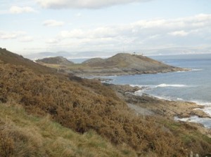
What a difference a day makes! When I alighted from the #118 bus I was treated to a very different Gower, with almost cloudless skies, a tranquil sea and views stretching across the Bristol Channel to Devon and Somerset. With a slight breeze to take the chill off the air I walked out to the coastguard lookout station 0verlooking the Worms Head. No chance of getting out to Worms Head for some hours as the tide was well in.
Looking out towards Worms Head
The next 7.5hrs was beautiful, walking mainly on springy and with few descents I was treated to stunning scenery which you normally associate with limestone country. There were a number of small valleys that I had to pass over which were probably the result of collapsed sea caves.
High Tor
At Port Eynon I was able to walk across the beach before re-joining the path again at Horton. My least favourite part of the walk was upon rounding Oxwich Point, the mile or so walking through Oxwich Wood were the path persistently went up and down steeply. I was pleased to see that Celandine had come into flower – always a sign that spring is around the corner.
Looking back to Oxwich Bay from Three Cliffs Bay
At Oxwich Bay the tide was well out and I was able to make a B-line for Pennard Burrows. On High Tor and the other smaller tors there were a number of climbers trying out their skills.
Looking towards The Mumbles
After passing through Southgate I was never far away from other walkers, particularly after Caswell Bay where the path became a tarmac route all the way to the Mumbles. I had decided initially to terminate the walk at the Mumbles, but I knew there was only one bus that went from there. I decided therefore to continue another mile on towards Oystermouth, where there more bus routes and would make it easier to resume my next section. The legs did not appreciate this though, as the 25 miles were taking their toll. I finished 8hrs after starting out from Rhossili. Perhaps one of the best walks along the Wales Coast Path.
Distance today = 25 miles
Total distance = 1429 miles
My attention next turned to tackling the Gower. I decided I would make a 2-dayer out of it, using Swansea as my base. I knew the weather would be not so good for the first day and my fears were soon realised as I drove down over the Brecon Beacons in a snowstorm!
Burry Holms
My first section was to be Rhossili to Gowerton, to do this section meant catching two buses. I parked in Swansea close to the hotel I was staying at and caught the 07:50 #118 to Rhossili at a cost of £4.80. When I alighted at Rhossili it was like stepping into a hurricane, although the horizontal rain was not too bad, the wind of 40 – 50mph was directly at me full-on. I had this for the majority of the day, especially when the path veered to a northerly direction. The first couple of hours was tough, particularly as I battled the winds along Rhossili beach to Burry Holms. I was forced to look down at the ground as the sand was whipped up and blasted at me.
Whiteford Burrows
I had a brief respite as I turned east, but then had the onslaught again all the way out along Whiteford sands.
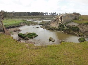
I encountered a couple of problems with the path around Cwm Ivy, the first was the collapse of part of the sea-wall.
Drifting sand at Berges Island
This was easily circumvented by clambering down to the right of my photo and picking my way over the wall debris. However, further up I was stymied by the stepping stones across one of the small channels, which were not visible. I could have easily vaulted the channel with the aid of my walking stick, but I had not brought it with me this time. So I then followed the high tide route.
Collapsed Sea wall at Cwm Ivy
Cheriton, Llanrhidian and Crofty came as the path eventually led onto a small flood-risk and high tide prone road. The road was quite welcome by this time as the state of the fields, particularly with livestock in them, made the going really tough.
I was able to enjoy fine views across the Llanrhidian Marsh and Loughor Esatuary towards Burry Port and Llanelli. This section had a great amount of tarmac, which I did not mind so much. I made good time and progress after Pen y Clawdd and soon arrived at Gowerton to link up with my previous section.
I then had to catch the second bus of the day back to Swansea. I was lucky and only had to wait 15mins for the #116 at a cost of £3.80. I was surprised at the cost of bus journeys (even short ones) around Swansea and Carmarthen. I suspect they do not attract the subsidies that services in Mid and North Wales enjoy. The walk had taken 7.5 hours for the 21 miles.
Distance today = 21 miles
Total distance = 1404 miles