137. Isle of Walney

It was back to Barrow today to do a complete circuit, well almost complete circuit of The Isle of Walney. This  low-lying island with a population of 10,600 is adjacent to Barrow in Furness but separated by The Walney Channel and connected by The Jubilee Bridge..

walk1371
Crepuscular Rays over Piel Island

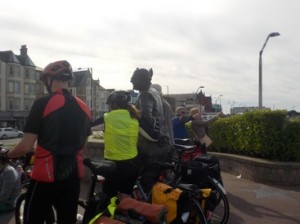
I decided to do the island clockwise, starting close to the Jubilee Bridge, on the Walney side. I parked for free on the Promenade and set off first to cross over and back the Jubilee Bridge. I then walked through the suburban streets of Vickerstown, keeping as close to the Walney Channel as possible. It was quite overcast and grey when I set off, with occasional showers. So I made sure I had my waterproofs on.

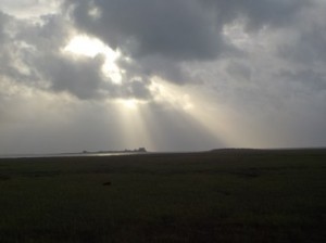
I was looking for a footpath, indicated on my map, that cuts across the marsh of Biggar Sands. I did not find the footpath and even if I did there was no way of crossing the marsh as the tide was in. I turned down Carr Lane, a quiet road that carried me south. Just before I approached the small hamlet of Biggar, a Barn owl flew out of shrub near me. It was beautifully white with tan patches and had an erratic flight as it scoured the road verges for voles. Although I did not have brilliant views, the islands of Roa and Piel were visible, in particular Piel with its grey castle. Both the islands were swathed in crepuscular rays, which gave them a heavenly glow!

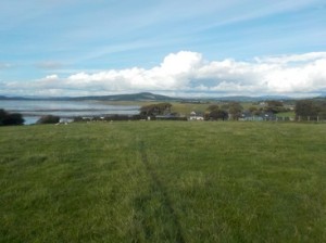
As I passed a caravan park I could now see the west side of the island and its hundreds of wind turbines offshore. The sea was quite choppy and the continual roar of the breaking waves would be with me for the most of the walk. The Isle of Walney has two Nature Reserves, one at the northern tip and one at the southern tip.

walk1372
No way – Thank you very much!!

The southern one, The South Walney Nature  Reserve has opening times and charges adults £3. Even if the Reserve was open, I would object to paying to gain entry. I crossed over a field to the west side of the island and began walking along the beach in a northerly direction. The North Walney National Nature Reserve has no such restrictions or charges in place.


walk1373
Heading north

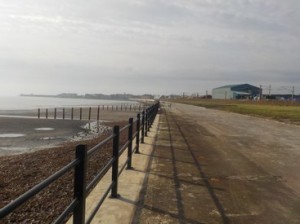
Walking along the beach wasquite easy, particularly if you found the right sand/gravel mixture which gave little give with each foot step. I continued on the beach until I reached the outskirts of Vickerstown on the western side. By now, people

walk1374
Classic Boulder Clay

were up and about , walking, jogging etc. I walked on the grass track which ran alongside an excellent footpath. I reach Earnse Point, which is at the end of the public road. The number of other walkers diminished as I now continued north along the broad expanse of beach.


walk1375
Looking across to Barrow in Furness

I see a numberof walkers have climbed aboard a small motor vehicle which disappeared up the

coast. I suspect this was something to do with the Nature Reserve. I eventually come upon the people in the vehicle and a few others who are collecting plastic on the beach. I have a quick look around and find some old plastic bottles in the sand, which I take over to them.

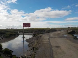
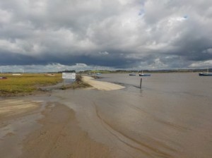
I eventually round the northern tip of Walney  at North End Haws and start to walk back towards Barrow. The next couple of miles are skirting around the salt marsh, which has a number of small paths going here and there! I have to cross a couple of the water channels, but the mud is firmish and presents no problems.


walk1376
Northen tip of Walney Isle looking towards Black Combe

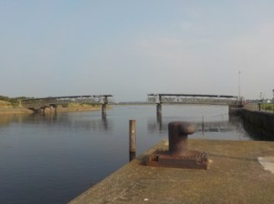
I am now walking  on the opposite bank to my walk of five days and I can look down the Walney Channel to see The Jubilee Bridge in the distance. I see little signs of the small airport that forms a large part of North Walney, although it could be the fact that it’s a Sunday and quite breezy!

walk1377
Crossing a small channel on the salt marsh

At North Scale, I transfer back onto dry land and walk down a small side street to emerge on the Promenade. I take 5.5hrs for the walk , at quite a fast pace.


Distance today =  21 miles
Total distance =   2249 miles


136. Ulverston to Askam-in-Furness

Today I was back in Cumbria continuing my walk around the Cumbrian Coast. However, there was a problem about what to do with the Isle of Walney, which barely an island at low tide is connected to the main land by the Jubilee Bridge. From my starting point in Ulverston, the distance to Barrow would be roughly 15 miles, if I were to continue to round the Isle of Walney, I would be stuck in the south part of the island without public transport. I therefore decided to bypass Walney and continue around the mainland to Askam-in-Furness. I would circumnavigate the Isle of Walney on my next visit.

walk1361
Dawn over Morecambe Bay
walk1362
Heading for Maskel Point

I wanted a very early start because I had a prior engagement in the early evening back in Telford. I parked in Ulverston and I started walking at 5:30. of course it was quite dark as I made my way down lanes towards the coast with head torch on. It was a lovely still and quiet start to the day. By the time I reached the coast I had no need of the head torch. The sun would not be up for another 45 minutes, but the light was good. I headed onto the beach and found a good medium of gravel and wet sand to walk on. The tide was ebbing as I continued along the beach. I could see Morecambe and the Heysham Power Station across the Bay.

walk1363
The Needle or Rampside Lighthouse
walk1364
Barrow-in-Furness

I continued about 100-200m offshore and the sand was quite firm. I rounded Maskel Point and Moat Scar. At Newbiggin a small stream outlet had me coming inland to get over it. Closer to the shoreline there was a lot more mud/silt which was not pleasant too walk. I stayed on the road from this point on. I walked along a very wide footpath which ran along the main road through Roosebeck and on to Rampside. At Rampside I pass The Needle, a slender and tall square tower, made from bricks and was built as a lighthouse. It has long been disused. I look offshore into the Bay to see Roa Island which is a tiny piece of land having a few houses and connected by a small tarmac road. At Rampside I take the cycle path which weaves its way around Natural Gas terminals, before passing derelict buildings and then going underneath the railway. On the cycle path I get a quick glimpse of a stoat/weasel about 10m away, I second in the last 7 days! I am now in Barrow and it is a pretty dull, bland and a dirty sort of town.

walk1365
Walney Channel

I take the High Level bridge, which is a road bridge that goes over to Barrow Island (which is not really an island at all) and passes above the Docks, which have locks to retain a good water level, as the tide is well out by now. I notice an awful lot of BAE buildings. Most of the work here is maritime for the Mod, submarines refit’s are still carried out here.

walk1366
Looking across to Walney – note the small wooden bridge

I reach the Jubilee Bridge which continues across to the Isle of Walney. I head north along a cycle track and footpath which takes me out of the town. The path passes through the Dock Museum, which is free to enter, but holds no particular interest to me. The Northern channel separating the Walney from the mainland is virtually devoid of water and would be quite easy to cross at a number of points. I had passed a small wooden bridge (covered by high tide) which crossed a small channel about 400m from Jubilee Bridge, but as I move to the outskirts of Barrow I decide to get back on the beach which again is easy walking. There are occasional patches of sticky mud, but the ground is firm and at these points I could easily walk across to Walney Island.

walk1367
Heading for Askam-in-Furness
walk1368
Askam’s waiting room and it’s door!

I enter Sandscale Haws Nature Reserve and continue north. It’s quite difficult to tell at this point what is the mainland and what is Walney Isle. As I pass the NT car park I can see Askam across the empty Bay. I walk in a virtual straight line to the start of Askam Pier. Askam Pier is not a pretty sight, having been constructed by dumping slag from the local Iron works (long since gone). I speak to a local chap back on the shoreline, he tells me the town was based on the Ironworks due to the local supply of iron ore. The spoil tips and large pools are a testament to this previous industry. I reach the observation point and walk back the short distance into the small town to catch the train back to Ulverston. The waiting room at Askam station is………..different. Its a bit like an old barn, with a single continuous bench down one wall and has a huge swinging door ( a bit like a barn door), the place stinks of urine.

It takes me about 7 hours to complete the walk.

Distance today =  22.5 miles
Total distance =   2228 miles


135. Ayr to Saltcoats

Today I expected a bit of a bland affair with a simple walk up the coast with a major detour inland, in actuality it was far from bland!

I parked my car at Newton-on-Ayr rail station, just around the corner from where I stayed the previous night. It was very dull and overcast as I set off. The tide was ebbing again, so I was able to walk along the beach. The cool air and the absence of any wind enabled me to get up a good head of steam. After rounding a small headland I transferred onto the promenade at Prestwick. Few people were about and Prestwick looked deserted. I heard little coming from the airport as yet, which actually dwarfs this small town. I’m back on the beach again but must make a small detour inland to get over Pow Burn. I continue along the beach and have just entered Royal Troon Golf course. I keep well away from the shoreline, trying to take a direct route towards the town of Troon. I begin to pick up the dog walkers and joggers from Troon itself.

walk1351
Approaching Troon
walk1352
Airbus Beluga

Although the views are minimal in the morning mist, a small piece of land offshore has captured my attention. I speak to a couple of lady dog walkers and ask what that island is, they tell me its called Lady Isle, a small uninhabited isle with lighthouse 2 miles offshore from Troon. I press on into the town. As I enter the town, I see the first of many flights beginning their descent into Prestwick. This first one of the morning was a really strange plane, I could read the markings which had it as an Airbus Beluga cargo plane, in fact  No.4 of a fleet of 5 planes used for shipping Airbus parts around the world – a very strange beast. I walk out to the far tip of thin strip of land that juts into the Firth of Clyde. The majority of area is one huge wood-processing plant, taking raw timber and producing a host of wood products. It looks extremely busy. I round the tip and begin walking back into town and heading north again.

walk1353
Barassie Beach – Looking back to the two Police Officers

As I near Barassie Beach I hear sirens coming from a police car, which turns off the nearby main road and into a car park about 100m ahead of me. Two police officers get out and speak to an elderly man on the beach. There seems to be a lot of pointing out towards the sea. As I pass them I try to catch what is going on, but no joy. I continue on for about 200m and pass three neatly folded jackets, with nobody in sight. I decide to return to the two police officers and ask them if the jackets have anything to do with why they are here. It turns out that the elderly gentleman had spotted some splashes some 300m offshore. I offer the Police the use of my binoculars. I have a look myself and can pick out three swimmers with buoyancy aids swimming. They don’t look in distress. I show the Police the 3 jackets I found and get on my way. I think the elderly gent  was right to call the emergency services, although really it should have been the Coastguard and then perhaps the Police.

walk1354
Bridge – well part of- across the River Irvine
walk1355
Stoat

I now have a good 3.5 mile walk along the beach towards Irvine and my inland detour. Eventually, I come to the mouth of the River Irvine, which has been confluenced about 300m inland with the River Garnock. The connecting bridge, which is retractable, has been left in a retracted state for some time; thus my 4 mile inland detour! The Science Park or Big Idea, which sits across the river, went bust over 10 years ago. As I pass the bridge I notice a chap taking pictures of something on the ground. I look closely and can see a Stoat going about its business. I take a photo, but have not got a zoom lens. I’m pretty sure it was a stoat, as it appeared to have a black bit on its tail.

walk1356
The middle advert between the MOT signs advertises funerals!
walk1357
Bridge over the River Garnock

I turn inland towards Irvine and alongside the old dock quays. I notice amusing set of adverts on the side of a shop called The Roll Shop – check out the centre advert. Its getting quite warm now as the sun has just shed its mantle of cloud. I skirt around Irvine, crossing the River Irvine, continuing towards the busy A78. I meet a couple who have just been harvesting fruit from a long overgrown orchard. They offer me an apple and advise that there is a possible  short-cut to Stevenston. I think about it and then decide to have a go! Big mistake, there are 3 challenges i) Getting under the main rail line – which was easy through an underpass; ii) Crossing the River Garnock via an old bridge which was part of the huge ICI Noble Explosives works that covered virtually the whole of the Ardeer peninsular – which was easy iii) Getting through the complex and overgrown section back onto public roads – which was not easy. In fact an hour and a half later I was still thrashing about in extremely dense undergrowth. I passed around an incrediable multitude of derelict buildings, all overgrown. I also came up an against a seriously high fence, which had all the hall marks of KEEP OUT. As the majority of the fencing was gone or destroyed it was a case of working my way around the site. Later I realised that ICS Noble and Chemring still have an operational presence on the site. My shortcut didn’t save me time or distance. I was absolutely knackered when I eventually emerged from the overgrown hell.

walk1358
Approaching Saltcoats

I headed to the beach and continued towards Saltcoats. I did originally intend to walk to Ardrossan, but I was becoming fatigued after my exertions in the Ardeer jungle. I decided to call it a day at Saltcoats and hopped on the next train back to Ayr.


NB: I also publish all my Scottish Blog entries on the excellent Scottish Hills website, I use the same narrative, but larger photos and a few extra ones. They can be found here:

http://www.scottishhills.com/html/modules.php?name=Forums&file=viewtopic&t=21782

Distance today =  22 miles
Total distance =   2205.5 miles


134. Girvan to Ayr

Two more days this time continuing my trek up the Ayrshire coast, which meant I would need to do some decent mileage over the two days.

I decided to base myself in Ayr for the night stay-over. This meant parking in Ayr and getting the train down to Girvan to begin the walk. I actually parked in Newton-on-Ayr, a suburb of Ayr where my B&B was. The weather was absolutely beautiful, a lovely late summers day, with a gentle breeze blowing into my face all the way to Ayr. I had the train virtually to myself, arriving in Girvan bang on time at 09:00.

walk1341
Auld Stumpy – Girvan

I paid my respects first of all to “Auld Stumpy”, the local name for the clock tower and former jail. Todays walk would predominantly be following the Ayrshire Coastal Path (ACP). I crossed over Girvan Water via a small bridge and which led me to the shore and a small golf course. At the end of the Golf Course the ACP turned inland for a short distance. However, I clambered down onto the rocks and continued about 300m along the beach, until the ACP re-emerged. Just after the sewage works, which really stank today, I was able to transfer down onto the beach, with  an ebbing tide and good firm sand/gravel I was able to make good progress.

I continued along the shore until I came to the works at Dipple, the ACP again diverted inland to go around the works, while I continued along the beach. I had been heading, for some time, towards the lighthouse at Turnberry Golf Course. I followed the golf course from the beach and could see that there was some sort of competition on as there were a lot of men in white boiler suits acting as caddies. Close to the lighthouse, the ACP turned inland towards the road. I passed a number of old runways and aprons, confirming that a large triangular airfield was based here both for the First and Second World Wars. A memorial to those that served here can clearly be seen, in the centre of the course on a small hillock.

walk1342
Culzean Castle
walk1343
Making Coal Gas – Culzean Castle

The road into the village of Maidens was quiet and also had a an excellent footpath alongside it. I found a shop and bought cake and additional water. The ACP then entered the grounds of Culzean Castle. I got excellent views of both the grounds and the Castle itself. I was not sure if I was getting a freebie or not; then I realised this was a National Trust for Scotland site of which I am a Member. The ACP dropped down to the beach past the Gas Managers Cottage and house. I was amazed to learn how Culzean manufactured their own coal Gas and piped it around the Estate. I tried to get a distance shot of the Castle, as is on the banknote, but failed.

walk1344
Conglomerate at Croy

The next three miles was spent on the beach. At Croy I came across some fine examples of conglomerates, in situ or as fallen blocks from the cliff. I also noticed some rocks which appeared igneous, possibly Doleritic or Basaltic with random feldspathic phenocrysts. I also noted large green minerals which could have been olivine. Its been many many years since my Geology University days, so I am very rusty at rock and mineral identification.

The ACP climbs the steep cliff slopes at Katy Grays Rocks. At the top, although somewhat hazy I can make out Ayr and the two Cumbrae Islands in the far distance. I arrive at the small village of Dunure where I met Alec out walking his dog. We talked about this and that for about 30 mins before I went on my way. I had a brief look around the ruins of Dunure Castle which were interesting and had many information boards, even though they had miniscule print. However, I did make out that one of the previous Kennedy’s owners “roasted” a Commendator to force him to transfer some land deeds; fortunately, he was rescued and managed to recover from his ordeal. Dunure also has a charming little harbour, where I restocked with more water and pop.

walk1345
The Heads of Ayr

I stayed on the beach all the way around and below The Heads of Ayr, basically a large headland promontory. The cliff above relinquished and gave way to fields and a caravan park, from which many people where making use of the beach in the warm sunshine. At this point I decided that it would have been rude not to pay homage to Scotland’s favourite son, who was born 2.5 miles away in Alloway. Ok, this would mean a 2.5 mile detour inland, but I had had a great day walking virtually all along the beach. So I was off to pay my respects to the Burns Clan at Alloway. I followed a cycle route (#7) which followed the route of an old railway line. The old rail line had its own bridge across the River Doon as well immediately passing through a tunnel, with houses built above it.

walk1346
On the Brig o’Doon
walk1347
Robert Burn’s birthpace – Alloway

I visited the Auld Kirk of Alloway, where William Burns (Burn’s father) and his sister were laid to rest. unfortunately, The Burns Monument and gardens closed at  5 o’clock, but I managed to get a good view of the monument t from the street outside. I sauntered down also to the Brig o’Doon made famous in Burn’s epic poem Tam o’Shanter. Standing on the bridge I was amazed to see how steep the “hump” of the bridge actually was. I walked further into the village and pass the birthplace of Robbie Burns. Its siting now seems quite incongruous with what has become a busy road alongside it. I head into “Auld Ayr” in search of “honest men and bonnie lassies”

walk1348
Looking west from New Bridge over the River Ayr

My B&B is still a mile away, so I decide to have an early dinner, I pop into the local Wetherspoons, The West Kirk, a church which still retains many clerical features, although perhaps not sobriety anymore! Perhaps one of the best coastal walks I have done  in Scotland, as yet. The unhindered walk had numerous sights and sounds made this an exceptional section.

NB: I also publish all my Scottish Blog entries on the excellent Scottish Hills website, I use the same narrative, but larger photos and a few extra ones. They can be found here:

http://www.scottishhills.com/html/modules.php?name=Forums&file=viewtopic&t=21772

Distance today =  25.5 miles
Total distance =   2183.5 miles

133. Flookburgh to Ulverston

Today I am starting off where I hit land 3 years ago when I did my cross Bay charity walk with daughter from Silverdale. I park up in the station car park at Cark as I intend to get the train back from Ulverston.

walk1331
The Sticky Toffee Pudding company – Flookburgh

I set off walking towards Flookburgh, then continue down a straight road that takes me past a place where I make Sticky Toffee Pudding – my kind of employment! I head towards West Plain farm, which sits close to Cark airfield and right next to the sea wall. The morning has an autumnal feel about it, the grass is sodden from yesterdays downpour, the sky is overcast and there is a slight chill in the air. The sea wall is easy walking as i head west towards the River Leven estuary, which flows from Windermere into Morecambe Bay. I round Cowpren Point, walking north now until I reach Sand Gate. I follow the Cumbrian Coastal path, which is a bit of a joke as a Coastal pathy or as any Path really, inland to Cark. I am almost back at where I started this morning and very close to the station. I head out north along the B5278. At the entrance to Holker Hall, I must make a decision on my route. I would have preferred the shorter, quieter route along the foreshore, but Holker Estate do not like walkers walking on their land or foreshore! Needless to say I would never advocate the use of any of their businesses, two can play at that game! I could continue along the B5278 all the way to the bridge near Haverthwaite, but the road has little footpath, a small amount of verge and quite a bit of no verge with twisty bits. The only safe option is to follow the Cumbrian Coastal Path which takes the high route over How Barrow.

walk1332
Looking towards Ulverston over the Leven Estuary

The climb up is quite easy and I am soon crossing very wet fields, from one farm to the next. About half a mile after passing Speel Bank Farm, I notice my glasses are missing. I had been carrying them resting on the top of my fleece. I’d dropped them somewhere, which I have done 6 or 7 times before. I walk back about half a mile looking for them, I then walk back the half mile I have just walked back. I decide to go back even further. No joy. It has happened before, but I have continued to dangle them atop my fleece. This time I have lost them for good. Serves me right!! The upshot of this is an extra 4 miles over tough terrain and almost 2 hours lost. Which has drained me!

walk1333
A tranquil Bigland Tarn

I press on past Bigland Tarn , which is perfectly tranquil and still. The CCP then descends to the main road, although the descent down a path which has been become the local stream. I pass numerous GOML signs left and right as I descend. I am dumped back on a very busy B5278 for a short distance, which confirmed my fears of it being very dangerous. I head west along a private road towards Roudsea Wood nature Reserve, the single track road is also busy and I have to stand back into the trees to let cars pass. I pass through the reserve and out into a field which then continues to the footbridge which crosses the River Leven to Greenodd.

walk1334
Crossing The River Leven at Greenodd
walk1335
The end of the line for the Ulverstaon Canal at Canal Foot

What awaits me on the other side is almost 1.5 miles of verge walking along a very busy A590 dual carriageway, is quite like walking up along the M1. How the CCP can be routed along such a road is mind-blowing!! I survive the A590 and eventually turn off down small and quiet lanes, which lead me to Canal Foot. Basically, Canal Foot is a small hamlet on the Leven Estuary where the disused Ulverston Canal used to link up with the sea. Although the canal is still full of water, the lock gates have rotted away. I suspect the canal has been dammed at its seaward end. I follow more lanes past the large GlaxoSmithKline (British pharmaceutical company) factory. I am running late now because of my specs and I eventually locate the station, where I catch the 15:15 train back to Cark. I have some luck in not having to pay my rail-fare of £1.85 as the conductor was very busy and the journey time was only 8 minutes. I offered to pay but was waved on by the Conductor.

Not a bad days walking, even though I did lose my specs. BTW, I have some spare old ones, although I do not need to wear them all the time.

Distance today =  19 miles
Total distance =   2158 miles

132. Lancaster to Silverdale

Just over 3 years ago, together with my daughter Nicola, I undertook a charity walk across Morecambe Bay. The walk started at Silverdale and went across the bay to Flookburgh. Today I would be closing that gap, but mindful that it was going to be a long day and long distance between Lancaster and Silverdale.

walk1321
Crossing The Lune looking back at Lancaster

I parked my car close by to Gibraltar Farm, where you can actually buy raw fresh milk out of a machine. The area is not served well by buses, however, there is a train station some 2 miles away. So I had brought my push bike to cycle that distance to the station, lock my bike up and catch the 10:07 train to Lancaster. Being a Sunday this was the earliest train I could get and meant I did not begin walking until 10:30. I followed a footpath from the station down a quiet road towards the main rail bridge that crosses the River Lune. The bridge also carries a footpath which offers a good view back over Lancaster.

walk1322
Only one of the post legs is covered – I go on
walk1323
Approaching Sunderland with about 300m to go
walk1324
Literally seconds after arriving at Sunderland, the tide has covered the road.

I join a cycle way that passes through a sports ground and actually runs alongside a cycle race track. Eventually the cycle way emerges onto a road which runs down to The Golden Ball Pub. The road has obviously been covered by the tide, with debris and silt littering the road. In fact I am spurred on as after Overton, I must cross a marsh via road which is flooded at high tide. I check my watch and get a move on. Via a series of roads I enter the small village of Overton. I did contemplate heading straight for the road across Lades Marsh, but I did not want to miss out on going around Bazil Point. I head towards Ferry Cottage, but am stumped by a close gate with a notice saying ‘No Public Access’. I recheck my map, surely it cannot be wrong? Then I notice a way marker indicating the footpath some 10m away. The path leads me onto the foreshore and I round Bazil Point, noting the good views across the Lune estuary to Glasson Dock. I head back towards Overton along the shore and eventually arrive at the road across the Lades Marsh. I can see that the tide is coming in ……fast. I meet another walker coming the opposite way. we have a brief chat, he advises to get my skates on. I can see the hamlet of Sunderland some 400m away. I make safe ground with literally seconds to spare!! I stop, put my bag down and turn around. The road is virtually covered by water! Absolutely amazing the speed that the tide comes in. I have a quick-lunch break, watching the tide devour the road that I had just walked across.

walk1325
Sambo’s grave
walk1326
Heysham Power Station

I set off along a lane walking west to this small peninsular shoreline. I make a short detour to visit Sambo’s grave. This is a grave of a site of a dark-skinned cabin boy or slave, Sambo, who fell ill shortly after arriving at Sunderland. With no further concerns re: the tide I head north, passing Potts Corner, which has a public road coming down to the shore, where a number of cars are parked. I head on past these and straight towards the building that has dominated my views for the last couple of trips – Heysham Nuclear Power Station. I know I cannot walk around the power station so will turn right inland. However, there is a large caravan park in the way. I know there is waste ground sandwiched between the caravan park and the power station, but the high tide has meant I cannot continue along the shore. I enter the caravan park and walk around the periphery until I come to a hole in the fence which takes me down a footpath. I find a hole in the fence that leads across old MOD ground but parallel to the caravan park. However, my progress is brought to a short end when a large and high gate blocks my progress. I am forced further north until I break through some trees onto a golf course. Fortunately the golf course is quite quiet. I cut across the course and through some trees to emerge on the public road that leads towards Heysham. In retrospect I should have stayed in the caravan park and just walked to the exit.

walk1327
St Patrick’s Chapel

I walk down past the ferry buildings and enclosure, before turning right and following road that takes me alongside Half Moon Bay and becomes a coast path. The path leads up to St Patrick’s Chapel, which is in ruins. The site offers fantastic view right across Morecambe Bay. I walk through a few narrow streets and find a little cabin selling coffee and tea and cake. I buy a mug of coffee and a large slice of carrot cake. After 20 minutes I get on my way. I am on now one large promenade which will carry me along for the next 5 miles.

walk1328
About as close as I get to Eric !!
walk1329
Mother and Child reunion?

I enter Morecambe, which is buzzing with many people taking the late summer sunshine. There is a large Vintage Fair going on and I pass many ladies beautifully dressed in period clothing. There is a classic car fair as well as a group performing. I like Morecambe and I draw a comparison with a Blackpool, which is far more tacky, in your face and loud. Morecambe has taken its role as a seaside destination more in keeping traditional values. everybody seems to be having a nice time. I try to get a close-up of the Eric Morecambe statue, but is surrounded by a large group of cyclists who with their bikes are getting their photos taken. I take a photo of the statue surrounded by the cyclists and move on. The crowds thin as I continue north towards Hest Bank where I move onto the shore and also where the main West Coast line comes within a stones throw of the Morecambe Bay.

walk13210
The route ahead – Silverdale looks a long way off

I am now back on the Lancashire Coastal Path, as I continue along the shoreline towards Bolton Le Sands. I do enter Bolton le Sands or Carnforth but pass to the west and north, where I cross the River Keer by means of a wooden bridge. The afternoon seems to have disappeared as I approach the outskirts of Warton, which the LCP enters briefly before turning up hill towards Warton Crag, part of which is the result of an old quarry. I continue along a quiet B road for a few miles, before crossing under the railway line and some fields. I arrive just east of Jenny Browns Point and follow the road up to Gibraltar Farm. It’s now 7:30 in the evening and it has been a very long day, 27 miles is one of the longest distances I have ever walked in a single outing.  My legs are tired but I am happy. I drive the few miles to pick my bicycle up at Silverdale train station. The walk has taken a tough 8.5 hours.

Distance today =  27 miles
Total distance =   2139 miles