Quite a simple and short section today as I made the short drive to park in Hoylake on the Wirral.
Functional if a little drab
Todays walk would hug the coast all the way to the Woodside ferry terminal at Birkenhead and would be tarmac all the way along a level sea wall path. With a lovely sunny day and a nice breeze I set off towards Liverpool. I could see the docks ahead at Seaforth across the Mersey.
The “Pierrot” welcomes you to New Brighton
My legs felt really good as I decided to keep up a good fast pace. Besides the multitude of cyclists and dog walkers there was little of interest until I came into New Brighton. Shops began to appear as well as increased traffic and pedestrians. At Fort Perch, at the NW tip of the Wirral peninsular I turned east and headed downstream of the Mersey.
Fort Perch – housing exhibitions, cafes etc…The Black Pearl – who-arrrgh
The majestic and familiar waterfront of Liverpool began to open up as I passed into Wallasey. I pass the “Black Pearl” a play-boat for children made from old driftwood on the sand, its crew made up of kids and adults. I could hear a terrific boom – boom from across the river towards an old dock area. It seemed like a rock concert was going on. I passed the iconic Wallasey town Hall which stands prominent guarding the Mersey from a small hill. The Stena Line ferry passes me en route to Belfast. I can see little other activity as i pass the first of the Mersey Ferry terminus at Seacombe.
Ferry – Belfast boundWallasey Town hall
To get to the Woodside ferry and Birkenhead, I must detour inland a short distance to get around old docks and the Stena Line terminal. I am now following the Wirral Circular route which guides me through old quays and jetties and is very helpful. I passed many many plaques, providing information on ships lost at sea, built at Cammel Laird or saw action in either of the two Great wars. It is a testament to the role Liverpool played in trade and a memorial to all those that their lost lives at sea.
I arrive at Woodside Ferry Terminal in a quick time of 3 hors for the 11.5 miles.
Ventilation tower for the Kingsway Tunnel
Woodside Ferry terminal Birkenhead
“Resurgam” one of the first submarines ever built – should have been painted yellow
Distance today = 11.5 miles
Total distance = 1759.5 miles
After yesterdays exertions it was nice to know I would not be walking as far today. Overnight it had rained quite heavily so I knew I would probably be in for a soaking, particularly from wet undergrowth. I made a very early start by driving from Dumfries to Dalbeattie, parking there and then getting the 07:00 bus #372A to Sandyhills. The cost was only £2.15, fantastic value and probably a route that is subsidised.
Fishing nets near SandyhillsOn the coast path on Torrs Hill
I arrived at Sandyhills under leaden overcast skies, with a light persistent drizzle that would be with me for most of the walk. There is a well defined and signed coast path from Sandyhills to Rockcliffe, which I found easily by the caravan park. The path climbed steeply up and across Torrs Hill before dropping down to the small hamlet of Portling. My next hill, White Hill, was slightly more substantial, although the path cut over its shoulder. From White Hill I had a final look back towards yesterday walk across Mersehead beach and could also make out the lighthouse at Southerness. Ahead I could see Rockcliffe and Rough Firth. The path kept well to the cliff edge all the way to Barcloy Hill, before making a right turn to head into Rockcliffe along the banks of Urr Water, which twisted and turned all the way to Dalbeattie.
Looking towards Barcloy Hill
Before I entered Rockcliffe, I seemed to have taken a different footpath which led me around a small campsite. I emerged back on the path and continued past holiday home lets. There was little to Rockcliffe along its shoreline, other than a bus stop and some toilets. I took one of the two main paths that link the village with nearby Kippford or Scaur.
Rockcliffe
One of the paths is called the Jubilee Path, I took the other which started just next to the public toilets.
Kippford or Scaur
Kippford or Scaur contain more facilities than Rockcliffe, including an hotel/pub The Anchor, a yachting club, RNLI life-boat station. I remember visiting and staying in Kippford 41 years ago as a student on a Geology field trip, surprisingly it appeared little had changed.
A single road leads out of Kippford or Scaur to the main A710. I followed this road safe in the knowledge that I would only walk about 50 metres along the A710 today! I knew this because at Barnbarroch, a newly constructed/ signed Core Path #20 through the Dalbeattie Forest indicated that Dalbeattie was just 2.5 miles away. Great I thought! I noticed on the information board that regular post markers would indicate your position. I was heading for postmarker 13, which would bring me close to the outskirts of Dalbeattie
Yeaa right!!
However, at post #17 the forest road made a sharp turn left, but the newly constructed finger post pointed straight ahead up an hill along a much smaller but well trodden path. I ummed and rrrred. The head was saying follow the finger-post, the heart was saying stay on the main road. The head won and for the next 2 miles I was beating myself up for making the wrong decision. I knew where I wanted to be, but forest roads are notorious in taking you directions you may not necessary want to go in. Anyway, the long and short of it was I probably walked an extra couple of miles more than I should have before I emerged on the outskirts of Dalbeattie. The walk of just 12 miles had taken me 3.75 hours.
NB: I also publish all my Scottish Blog entries on the excellent Scottish Hills website, I use the same narrative, but larger photos and a few extra ones. They can be found here:
It was back to Scotland again for two more days of my walk around the coast of Scotland. As I managed to get another great room deal I stayed in a B&B in my favourite town in the south of Scotland – Dumfries.
I must admit I was not looking forward to this section because I knew it would contain a fair amount of road-walking, in particular, the A710. Although the road was not especially busy I still had to keep my eyes peeled and be alert for vehicles, some which were travelling at quite a speed.
To minimise the amount of road-walking I seriously considered doing a traverse of Criffle, as it was a hill that I had seen many times before from across the Solway on the Lakeland peaks. However, I had read reports of people who descended to the south-west who reported it was strewn with boulders, holes and deep heather, so it was the road for me!
I had roughly calculated that I would be doing about 21 miles, however, with my deviations and desire to stay close to the coast, I accumulated a whopping 27.5 miles, one of my highest walking distances.
The road to Kirkconnell House – mind the hedgehogs!
I parked in Dock Park and walked alongside the River Nith to the Kirkpatrick Macmillan bridge and crossed over the Nith. It was 6:40 in the morning and the weather was dry , dull and overcast. I followed the Nith downstream until the footpath came to a lane which passed some houses and joined the A710. There was a steady stream of early morning commuters coming and going in either directions, which I managed to safely negotiate.
Beautiful and colourful Broom
At Gillfoot I came to a smaller road, which would eventually take me back to the coast and would be much quieter. This road headed towards Kirkconnel House. I was certainly more relaxed on this road and able to enjoy the birds, deer and squirrels running before me. I also had a very strong pungent smell of wild garlic, particularly in the shaded areas for most of the day.
Sweetheart Abbey
At Kirkconnel House I turn left and pick up a signposted path that ran along the shoreline to two large storage tanks at Airds point. The tanks contained effluent and are released into the estuary at certain intervals. A case of effluent from the affluent?
The path passes through woods and fields full of sheep as I head towards New Abbey. I emerge on the A710 and make a small detour to visit the 13th century Sweetheart Abbey built by Lady Devorgilla.The Abbey, surprisingly, is still good condition compared to the ruins of Abbey’s close to where I live. I take a couple of photos from the perimeter fence but are not tempted to pay the £4 for a closer look.
Mobile Post Office
I retrace my steps and continue down the A710 for 4 or 5 miles until I arrive at the small village of Kirkbean. I turn left and continue a short distance on the road for Carsethorn before turning right on a smaller road heading onto the Arbigland Estate. I strike up a conversation with a local who advises me that I can get to the shoreline and walk all the way to the Mersehead Nature Reserve. I am pleased about this as I had planned to return to the A710, it also meant I would be doing a number of extra miles.
Criffle
I pass the cottage of John Paul Jones, reputed to be the founder of the American navy. Again I did not fork out the £4 to visit a few rooms of an 18th century cottage.
A nice and considerate gesture
I finally emerge onto the shoreline at Powillimount. I see from the signpost that this is Core Footpath No. 449. [I later learn about the Core Footpaths in Dumfries and Galloway and will use their site for future visits. The following link is to their Core Footpath route site. A tip to using this site is to zoom right into the area you are interested in and examine the route:]
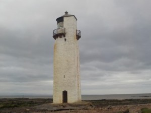
From the shoreline I can still see the Lake District and its tops, I can make out the familiar shapes of Skiddaw and the Buttermere tops. I head along the beach towards Southerness and pass its lighthouse, the second oldest in Scotland. As I round Southerness I can see that the tide is well out and I am able to walk along the fairly compacted sand towards the tip of Mersehead. I realise that with these extra miles I will miss my planned bus at 13:46 and have to get the 15:40. I continued all the way to Southwick Water and only a short stretch of water separate me from the A710. Unfortunately, it was not safe or possible to cross this water, which I knew anyway and headed inland to complete a 4 mile detour via Caulkerbush. When I reached the A710 again I had to take special care as the road rose, twisted and turned with blind bends, thankfully the traffic is light.
Mersehead
I eventually came to Sandyhills and I descended to the beach to save myself any additional road walking. The caravan park shop was still open and I purchased ice cream and chocolate biscuits while I waited for the #372 bus back to Dumfries. The bus fare was only £3.15 which I thought was pretty good for a journey that would take almost an hour. I managed the 27.5 miles in 8.75 hrs. Not as bad a day as I first thought.
NB: I also publish all my Scottish Blog entries on the excellent Scottish Hills website, I use the same narrative, but larger photos and a few extra ones. They can be found here:
At only 54 miles from my home in Shropshire, this was the second closest walk to the coast that I would make. I had opted for a shortish day to fill in the gap between Wales and Scotland as I begin to head north. I could have chosen a number of starting points to begin walking around the Wirral. Because of its good cycle and rail links (as well as being cheap to park) I opted for Shotton. So for the next 3 miles I would be walking in Wales again, although you would hardly notice it.
Crossing the Dee at HawardenIt said Neston 4 miles for about 2 miles!!Crossing the border into England
Starting at Shotton High Level station (I walked towards Shotton Low level station) both stations have routes that run perpendicular to each other. I soon joined up with the official Wales Coast Path as it follows the banks of the River Dee. I crossed this part of the path last August on my first section of the WCP. The railway bridge at Hawarden allows cycle and pedestrian traffic to travel over the bridge. This is cycle route #5 and I was soon to leave it for cycle route #568, a newly constructed path. I did have some reservations about this section, but it could not have been easier with excellent signage. The route passed around the large Toyota factory as well as other large industrial premises. It passed underneath the busy A548. A small lane ran alongside the railway towards the Sealand MOD firing ranges. Red flags were flying although due to the early time of the morning no firing was taking place. The firing range did not intrude into the walk at all. The views across the Dee Estuary began to open up and I could clearly make out Flint castle as i passed over the border into Cheshire.
The Harp Inn at Neston
The cycle way joined a small road as I skirted the outskirts of Neston, once a large coal mining area, which I was not aware of. I passed the famous Harp Inn and was pleased to get away away from the cyclists who had been in out in force, in groups of all sizes all morning.
Crumbling cliffs of boulder clay at Thurstaston
I stayed on the water front while passing through the small hamlet of Parkgate, a suburb of Neston. In actual fact it was very difficult to see any water at all, with salt marsh and sand /mud running alongside the shore. Eventually, I had to make a small detour inland to pick up the Wirral Way, a cycleway, walking route and bridleway following the line of the old Hooton to West Kirby rail link.
Sailing regatta at West Kirby Marine lake
At Thurstaston, I found a path to enable me to get down to the beach and walk along it. I could have probably stayed on the beach, but opted to detour slightly inland again to pick up the Wirral Way. The view across the Dee Estuary was terrific as I could now make out the “Duke of Lancaster”, as well a Little and Great Orme in the far distance.
Unusual lighthouse at Hilbrae Point
Within a mile of rejoining the Wirral way, I rejoined the beach and stayed on it until Hoylake. As I passed through West Kirby I could see a sailing regatta was being held on the large Marine Lake. I think the competitors were novices as many were struggling to keep their small dinghys on course. I walked along along the beach which was nice and firm and ran alongside the Royal Liverpool golf course, which sometimes holds the Open. The tide was way out and the tidal sand flats covered a huge area. I could see the small island of Hilbrae offshore and many people were heading for that.
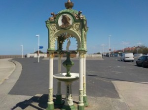
More like a desert than the coast!Charming water fountain at Hoylake
At Hilbrae Point I rounded the SW tip of the Wirral. I continued to walk along the beach and could not see where the waters edge was, it was that far out. I continued to walk towards the RNLI station at Hoylake, where I turned down one of the streets towards the train station. I had in fact unknowingly walked an extra station to Manor Road, Hoylake instead of Hoylake itself! I managed to finish the 18 miles in 5.25 hrs with a glorious sunshine all the time with a refreshing seas breeze to keep me cool.
Distance today = 18 miles
Total distance = 1708.5 miles
Today was almost entirely walking on road, so it was a case of donning my hi-vis vest and putting trainers on. Having spent a comfortable night in a B&B in Dumfries I opted for an early start, which meant having to forgo breakfast. I drove the short distance to the south of Dock Park to the first upstream bridging point of the River Nith – The Kirkpatrick Macmillan footbridge. Kirkpatrick Macmillan was in fact the inventor of the pedal bicycle and was a blacksmith from just north of Dumfries.
Dead straight
Having parked my car close to the bridge I then walked the half mile to the bus station close to the weir and caught the 07:00 #79 back to Cummertrees and walked down to Powfoot.
TSB – Ruthwell local branch
It was 7:40 as I continued to head west. I was pleased to see that although, the sun was up, there was a thin veil of cloud which masked the intensity I experienced yesterday. After passing through a holiday park and golf course I continued along on Cycleway route #7. I joined a small single track road, which was very quiet and dead straight. The land around was dead flat and reminded me of the Fens. Save for the song of birds and the occasional deer there was little to see. After 4 miles I arrived at the small hamlet of Ruthwell, famous for the location of the first Trustee Savings Bank, started by the Rev. Henry Duncun in 1810. The humble cottage which housed the Bank is now a museum, which was closed unfortunately.
Brow Well – a bit manky
Half a mile further up the road I joined the more busier B725, which although not the M6, still had traffic passing me at speed. Shortly after joining the road I came to Brow, a small hamlet, which is famous for its well – Brow Well. Robert Burns visited the well in July 1796 while in declining health, he died soon after. The well is currently being ‘done-up’ with a bit of landscaping here and there. The well was also drained, or rather let to run, as I could see just a trickle of water passing along an open gulley pipe.
Rear view spy glasses – yea cool man
I carried on along similar roads and decided to try out an idea that I had recently had. It involved the necessity to constantly check if a vehicle is coming behind you, particularly on single track roads. Ok I thought, what about those kiddie specs you get with mirrors inbuilt into the glasses themselves? Well £1.99 (incl P&P) later and a delivery from Fleabay, I packed them into my rucksack. Did they work, well yes and no. I usually wear a Tilley hat which slopes at the back, so all I was seeing was the hat. When I removed the hat I could see cars in the rear, although it took abit of practice while walking to focus on the mirror. I’ll pop them in my bag again and give em another whirl.
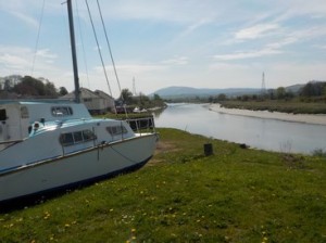
Kingholm Quay alongside the River Nith with Criffle in the background
The road eventually arrived at Bankend, which contained a few buildings and nothing much else. I continued down the B725, although the traffic had drastically reduced. I passed through the small hamlet of Shearington and was rewarded with an excellent view of the isolated granite peak of Criffel (569m), a hill I had seen many times while climbing in The Lakes and The Southern Uplands. I continued ahead and could see the ruins of the moated triangular castle of Caerlaverock. I was too tired to pay to walk around ruins, so I continued onto Glencaple meeting the River Nith flowing south from Dumfries.
Kirkpatrick Macmillan footbridge – Dumfries
I rested at Glencaple and decided to follow the riverside path all the way back to Dumfries. The path was abit sticky in places, but was well marked and had a number of small wooden bridges for the larger streams. I came to Kingholm Quay which had a pub and other old quayside buildings. It also marked the start of the tarmac path into Dumfries, the know, the sort that joggers use? I finished the walk in 5.5hrs for the 19.5 miles.
NB: I also publish all my Scottish Blog entries on the excellent Scottish Hills website, I use the same narrative, but larger photos and a few extra ones. They can be found here:
Today would be my first steps in walking the coastline of Scotland. I had purposefully ‘leap-frogged’ the section from Chester to Gretna because I wanted to make a start on the Scottish coastline with the chance of having better weather plus having more hours of daylight to complete my walks in. So the emphasis over the summer of 2016 will be to concentrate on Scotland in a series of two or three day trips. Whenever I just fancy a single days walking I will continue walking north from near to Chester which, over the Winter months will become my primary objective.
The Bridge over the River Sark from the Scottish sideThe Old Toll Bar – first and last house in Scotland
For my first section I intended to start on the English/Scottish border, which is the bridge over the River Sark close to Gretna. Before I could do this I had to drive to and park in the small hamlet of Powfoot further up the coast. I then had to walk half a mile up to the main road, to the B721 from where I was able to catch the 7:30 #79 bus to Gretna. The small red sandstone bridge over the River Sark is quite inconspicuous as the border between Scotland and England. Anyway, photo record completed I set off on a footpath along the River Sark back into Gretna.
I head through Gretna towards the Old Graitney Road which has light traffic on it. After passing over Kirtle Water I can now head for the coast. I turn down a quiet road towards Rigfoot and continue to the farm at Redkirk. Here I follow a green lane to Baurch where I turn towards the coast. I say “coast”, but the tide is out when I arrive at the shoreline. The morning is bathed in glorious sunshine, but with a fresh breeze. The breeze and sun is at my back as I head west. I intend to stay close to the shoreline for as long as possible all the way to Powfoot. The shoreline path is perfectly walkable, but is dotted with thousands of small gullies holding tidal water. Its just a case iof watching where you put your foot.
The Solway shorelineWalking alongside the “Devils Porridge”Obsolete warning signs at Devils Porridge
After passing Browhouses I join the perimeter of the huge ex-MOD site at Eastriggs. HM Factory Gretna was a huge industrial complex stretching for 9 miles! Renowned for making the “Devils Porridge” or cordite during World war 1, used as propellent for shells, the site now houses industrial units. The perimeter fence is still intact and in good condition. I follow the fence for awhile. I round Torduff Point and continue along the shoreline. The morning haze has begun to clear and I make out the Cumbrian coastline with Skiddaw prominent and the small hamlets of Port Carlisle and Bowness-on-Solway across the Eden Estuary. I pass the homesteads of Dornockbrow, Battlehill, Whinnyrig before coming to a small man built promontory at Seafield. The raised dyke used to have a railway running along its top, but now just has a large discharge pipe. I pass over the dyke and down onto a large flat area of salt marsh called the Merse. I walk along a small levee towards Waterfoot, which many years ago had a dock and discharged goods under the watchful eye of excise man Robert Burns.
The Merse looking towards AnnanCrossing the River Annan
I now had to get over the River Annan which meant following a single track road into Annan and passing under a railway bridge. I now joined up again with National Cycle route No.7 which I would be with for a while. I was able to cross the Annan by an excellent footbridge. As I emerged from the footbridge I got into a long conversation with a chap walking his dog. We must have spoken for about 30 minutes on this and that, after which I met another chap on a bike who had cycled down from Inverness along the No. 7 route, we also spoke awhile.
I eventually got back to walking and set off through Newbie, noting the large boiler works of Cochran. I rejoined the coast at Newbie Mains and could see the small hamlet of Powfoot in the distance.
Powfoot
There was further evidence of the HM Factory Gretna on the shoreline with large areas of debris scattered about. I noticed some of the bricks were cream and had the name Timmis and Son Stourbridge stamped on them. I later found out that Stourbridge (West Midlands) was a major source of Fireclay bricks, anyway I salvaged one, even though it weighed a ton, but I only had a short distance to go before I was back at the car. It took exactly 6 hours to cover the 16 miles, but expect 45 minutes of that was spent in chatter along the way.
NB: I also publish all my Scottish Blog entries on the excellent Scottish Hills website, I use the same narrative, but larger photos and a few extra ones. They can be found here: