250. Ruabha Reidh to Poolewe

I was pleased that today I would finally have some off-road walking to do and that I would not be cycling or pushing my bike! To enable to happen I had to first drive and park my car  at Poolewe and then catch the o8:05 Westerbus back to Gairloch. Bob (the guy running the AirBnB) had offered to assist me in completing the section to Poolewe by waiting for the bus to arrive and then giving me a lift out to Rubha Reidh. I had already ruled out doing the whole of this peninsula in one go because of the available daylight hours.  I set off from the visitor car park at Rubha Reidh, walking eastwards, not wishing to lose too much height as I headed for a footpath that ran along the cliff-tops.

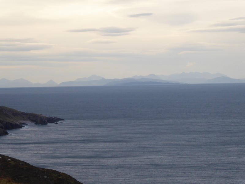
After meeting up with the footpath, I could to see the amazing coastline features this part of the peninsula had to offer. What was also amazing was the early morning views north into Assynt. Although I had views of Assynt from northern Skye, I was now able to easily identify the iconic mountains of Sutherland and the Fisherfield Forest. The early morning light gave them all an amber glow that defined their colour and relief. The footpath hugged the cliff top and required care in certain places. The northern part of the peninsula I was on had high moorland to the west and a low-lying  side to the east, full of small lochs. I began to lose height above Camas Mor, an isolated sandy beach that is quite popular and a major reason walkers make the trek out here.

As I arrived at the old ruins of Camustrolvaig, I found Ivor’s bothy, set into the hillside and not easy to see from the approach I made.  I don’t think the bothy is part of the MBA and you can probably see why. To be honest it looks like it might fall down at any minute. The bothy has just a single room and seems to have a tarp for a roof. Although very dark inside, it looked very cosy and dry.

Early morning at Rubha Reidh looking north to Assynt
The coastline of Creag Camas an Fhraoich
Looking eastwards from above Camas Mor
Ivors Bothy

I  now headed for the settlement of Cove on the far side of the peninsula on the shores of Loch Ewe. I knew once I got down onto the low-lying area it would be much more difficult navigate, so I headed for a Loch I identified on the map and would continue from there. For such a low-lying and boggy area the underfoot conditions were not bad and I was able to hop between outcrops of  slightly firmer higher ground. I navigated between the small lochans and crossed over the Allt Glac nan Cuille. Shortly after, while walking over boggy terrain, I went ar$e over tip as my left boot went into a pothole. I was ok, just landing in grass and getting a muddy knee! Soon afterwards I arrived at the strung-out settlement of Cove above Loch Ewe.

Heading eastwards

Loch Ewe has some fantastic history, particularly what happened there during the Second World War. Arctic Naval convoys gathered in Loch Ewe before setting off on the treacherous journey to Russia. Reminders of this piece of history are still present around the Loch . The road walk down to Poolewe was quite uneventful but offered some beautiful views into the Fisherfield Forest with dramatic views of Beinn Airigh Charr, Beinn Lair, Beinn a’Chaisgein Mor and A’Mhaighdean. After passing through the hamlets of Cove, Inverasdale, Midtown and Naast I arrived back at the village of Poolewe.

Looking back at the settlement of Cove
Looking north up Loch Ewe with the morning Cal Mac ferry off from Ullapool to Stornoway
Looking towards Poolewe over Loch Ewe with A’Mhaighdean(l) and Beinn Airigh Char(r)
Zoomed shot looking towards Poolewe with Beinn Airigh Charr in the background
Beautiful bark on a Eucalyptus tree near Naast
Looking back up Loch Ewe from Poolewe

NB: I also publish all my Scottish Blog entries on the excellent Scottish Hills website, I use the same narrative, but larger photos and a few extra ones. They can be found here:

http://www.scottishhills.com/html/modules.php?name=Forums&file=viewtopic&t=24435

Distance today =  14 miles
Total distance = 4,499 miles


249. Rubha Reidh to Gairloch

This was to be a very straightforward day; simply get out to the Lighthouse at Rubha Reidh and then get back to Gairloch. As there is no public transport out to Rubha Reidh, I needed to make use of my bicycle again. The forecast for the wind direction had not changed, except that it had become increasingly stronger and colder. As the wind was coming from the south-east I decided to cycle out to the Lighthouse.

I started out from the B&B at 8:50, just as it was getting light. The wind had increased overnight and it was bitterly cold. The strong tail wind certainly helped with the speed of my progress and enabled me to cycle up slopes that I would normally have to push the bike up! After passing through Melvaig I joined the private road out to the lighthouse. Recently the owners of the lighthouse had taken active measures to prevent people driving along the road. When I travelled along the road I could see no evidence of obstructions or unwelcoming signage. In fact there was a visitor car park 300m from the lighthouse signed and erected by Inverasdale Estate, Melvaig Crofters and Gairloch Community Council. The road was very well maintained with an excellent surface and recently installed culverts and bridges. I spoke to some locals about the road and the main issue seems to have been the number of camper vans using the road and causing problems.

I reached the lighthouse and immediately turned around and headed back to Gairloch pushing my bicycle. I had excellent views out towards the Western Isles which seemed very close. The tip of the peninsula out at Rubha Reidh sits well out into The Minch, with northern  Skye now to the South. The wind was biting as I headed back into the strong head-wind. After 3 miles I was back at Melvaig and on the public road. I quickly passed into the adjacent settlement of Aultgrishan. The road passed over open moor before coming to the scattered settlement of North Erradale.

The lighthouse at Rubha Reidh
Looking over to Trotternish on Northern Skye
Looking south towards Rona, Raasay and the south of Skye
One of the recently built bridges on the private road
Looking south over Melvaig
The Allt Grisionn at Aultgrishan
A beautiful Scottish Blackface at Aultgrishan
Looking back north from Big Sand
Approaching Gairloch
Two Lochs Radio – Gairloch

By the time I reached Big Sand, time was moving on and I was already beginning to lose the light. I arrived back in Gairloch and went into the McColls shop to buy something for me and Bob’s supper. On my way back to the B&B I noticed a small shack housing the Two Lochs Radio studio. Anyway, I immediately had visions of Gregor Fisher inside transmitting his OHBC (Outer Hebrides Broadcasting Corporation show):-

oidhche mhath

Not a big day, but progressing long distances at this time of the year is difficult.

NB: I also publish all my Scottish Blog entries on the excellent Scottish Hills website, I use the same narrative, but larger photos and a few extra ones. They can be found here:

http://www.scottishhills.com/html/modules.php?name=Forums&file=viewtopic&t=24434

Distance today = 13 miles
Total distance = 4,485 miles


248. Gairloch to Red Point

I had spotted a weather window which offered a three-day dry spell with light winds and looking reasonably warm for the Gairloch area. I then decided to try my luck with local accommodation in and around Gairloch, as being stuck in the back of a car or in a tent  for three nights was not very appealing. I searched on the AirBnB site and was surprised to find a number of reasonably priced accommodation. I selected “Bob’s Place” which was newly listed on AirBnB and based in the centre of Gairloch. Bob is a keen and  avid walker, and enjoys both high and low-level walks; so much so that he recently relocated to Gairloch from his Bristol home. Bob has accumulated an amazing volume of walking kit and equipment which is well on a par with any reasonably stocked Tiso Store! I had my own room at Bob’s Place for two nights at a fantastic rate.

The Gairloch area unfortunately does not have the best transport links, but with my bicycle, a school bus and a lift from Bob I could make a serious stab at getting to Poolewe after three days of walking.

I drove up  the day before and reached the car park at Incheril, Kinlochewe , where I slept in the car for the night. The place was empty again and I had a quiet night. I set my alarm for 08:00, but it was still quite dark when I looked out of the window, so I drove very slowly down Loch Maree waiting for it to get lighter. I arrived in Gairloch and parked at the Community Hall.

As soon as it was just about light to begin walking safely, I set off. I popped into the local McColls shop to get a coffee and continued along the A832 pushing my bike. Because no public transport runs out to Red Point I was going to have to do an out-and-back, using my bicycle for the return leg.

Gairloch is quite a strung-out community and merges into another local settlement of Charlestown. I enjoyed walking on a good footpath alongside  the main road to the far edge of Charlestown, although the road was not particularly busy at 8:45 in the morning. After Charlestown I was walking along the verge for a few miles until the turn off for the B8056 which pointed me across a bridge over the River Kerry and on to Red Point.

Looking back towards Gairloch
The beach at Gaineamh Mhor
Gairloch Harbour

I soon arrived at the small hamlet of Shieldaig, confusingly spelt the same as the Torridon Sheildaig and with its own Loch. I got superb views over Loch Shieldaig back towards Gairloch. I climbed out of Shieldaig and followed Loch Bad a’Chrotha, which had originally been dammed, but was now breached at its western end to allow outfall from the Loch. I descended into another village, Badachro with its own popular Inn and jetties offering shelter to yachts and boats. I climbed out of Badachro and followed the shoreline of the freshwater loch of Loch Bad na h-Achlaise. I then passed through a series of widespread settlements with  a range of white houses scattered either side of the small single tracked road. I passed through Port Henderson, Opinan and South Erradale.

The road rose again for the final time before dropping down to Red Point. I had excellent views looking east towards the Flowerdale mountains, south-west across to Rona and Skye. Although I had occasional patches of blue sky, the sun did not make an appearance all day. At Red Point I simply turned around and began cycling back to Gairloch, where I arrived back at 14:45 with the light disappearing fast.

The bridge across the River Kerry
At Shieldaig looking across Loch Shieldaig across to Gairloch
The breached dam on Loch Bad a’Chrotha
At Badachro looking across to Charlestown
Looking back to Port Henderson
Victorian post box at Red Point embedded in rock
Looking south towards Rona, Raasay and Skye
Looking down on Red Point Beach with the lighthouse on Rona in the distance

NB: I also publish all my Scottish Blog entries on the excellent Scottish Hills website, I use the same narrative, but larger photos and a few extra ones. They can be found here:

http://www.scottishhills.com/html/modules.php?name=Forums&file=viewtopic&t=24432

Distance today = 13 miles
Total distance = 4,472 miles