I thought it would be a good idea to have a visual representation of my progress to date in walking the coast of Great Britain. This is basically just a Google map of Great Britain with a red line indicating my progress, its rather crude, but does the job.
The day had finally arrived when I would do my final coastal walk in Scotland and I knew it would be a tough one.
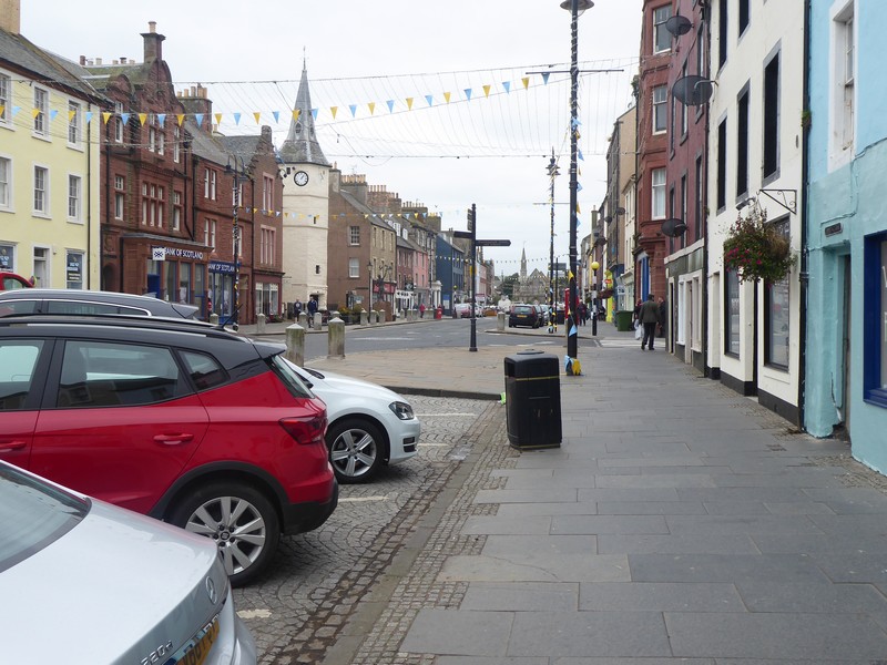
The overnight rest at my B&B in Berwick had certainly done the trick, my legs felt ok and I felt confident of taking on another gruelling day. I decided to make a very early start as the forecast was for a bright sunny day and I wanted to get some of the walk done before the sun was high in the sky. I parked my car at a small car park, just up from the pier in Berwick-upon-Tweed and then walked back into Berwick and headed for the railway station. I caught the 05:30 #253 bus to Cockburnspath. This service is run by Borders Buses, an offshoot from the West Coast Motors bus company across in Argyll. With their distinctive livery I thought they provided an excellent service and where probably my favourite carrier to date. I chatted to the driver before we departed, he was from Berwick, and was complaining that the Government had just put most of the NE of England, from Northumberland down to Teesside into local lockdown, due to a surge in Covid-19 cases. I was therefore quite lucky, in that, I would not have been allowed to travel and walk in the area later that day.
I got off the bus in Cockburnspath and it was still quite dark. Cockburnspath is a sort of path terminus for the start/end of the Southern Upland Way, the John Muir Way Link and the Berwickshire Coastal Path which I would be following off and on throughout the day. For the next couple of miles I was still using my head torch as I headed down to the large leisure/holiday homes complex at Pease Bay.
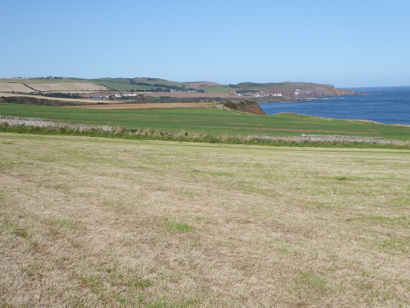
The climb up out of Pease Bay was very steep and because of the tight narrow road a wooden flight of stands was provided for pedestrians. I chose to walk along the road instead. I was heading for the old coast road which ran along much higher ground and provided the best views up and down the coastline. Far below me was Siccar Point, famous in geological terms for the site of Hutton’ s Unconformity, it was a long way down and a long way back up, so I carried on. I passed though the old hamlets of Old Cambus West & East Mains, then through Redheugh Farm where I gradually gained height south eastwards to the much higher ground of Harly Darlies at 230m. Here I picked up the Dowlaw Road, which ran towards the Dowlaw Farm. Dowlaw Farm offered camping for £15 per night, but I’m not sure what you actually got for your money as they called the payment a “donation”.
The walking after Dowlaw Farm was hilly sheep and cattle country, but the going was easy and up until now my legs felt ok. After passing some Admiralty Distance Poles, apparently used to measures nautical miles, the cliffs began to gain some serious height. When I came to Waterside Dean I descended steeply into a huge gully and then had to climb back up to 161m. It was quite a test on my legs and with the heat was tough going.
Walking down into Pease Bay at first lightLooking back northwards towards Torness Power StationWalking around Dowlaw DeanCrossing over Dowlaw BurnThe cliffs above Lumsdaine ShoreOne of the Admirality Distance Poles used to measure a Nautical MileLooking towards St. Abbs HeadHeading down steep slopes into Westerside DeanLooking towards St. Abbs Head
I was now able to look down on St Abbs Head, which was a lot lower than the ground I was on. The walk down to and then up onto St Abbs Head was not too bad. I was rewarded with great views both north and south along the Berwickshire Coast. As I descended towards the small fishing village of St. Abbs I met more walkers who were heading up to St Abbs Head. The red sandstone cliffs in the area were very impressive and with the path exposed, a trip could easily have dire consequences. I did not descend down to the harbour in St Abbs, as even small descents and consequential re-ascents is something that my mind is telling me not to do. I did pop into the tiny village Post Office where I bought more drinks to keep me going. However, between St Abbs and my next destination – Eyemouth there were numerous descents down to the beach and back up the cliff, which were becoming painful.
Eventually I came into the larger town of Eyemouth, which was quite busy. I popped into a co-op to buy further drinks, even though I was carrying plenty of water still. I have developed a taste for those iced coffee drinks, which tend to distract or take my mind off the complaining what my body is trying to tell me!
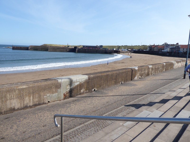
When I reached the village of Burnmouth I was joined by the main East Coast Rail line, this was quite important, as it marked the final section of the walk where the railway line, the A1 road and the coastal path were ‘pinched’ tightly together between the sea and the higher ground. I crossed under the railway line for the final time. As I passed Hilton Bay I saw a sign for a bothy down the cliffs towards the beach. I had a quick look but could only see the ruins of a cottage. At Marshall Meadows I passed through a gate and was back in England. The next 4 miles back into Berwick-upon-Tweed was certainly not a stroll, as I had 4 miles of quite painful walking with my legs and ‘chafing’. It was not enjoyable.
Back at the car I could sitdown, relax, change clothes and shoes and begin to reflect. I had started walking from Gretna back in May 2016, knowing that walking around Scotland was going to be the biggest challenge that my walk around the coastline of Great Britain was going to face and so it turned out to be. I had visited many many places that I had not been to on the hundreds of previous visits to climb hills and mountains. I also felt quite sad at finishing something that I, for the main, really enjoyed doing. I must also thank those fellow walkers on the ScottishHills site, where I also post my Scottish walks, who have lent advice and support during my quest.
But it’s not over, apart from two estuary walks in Cornwall, the remaining gap in my walk is between Sandwich (in Kent) and Poole (in Dorset) – 20 more walking days. But even as I write this the ugly head of potential lockdowns looms imminent for us all.
Heading down over easy pastures towards St. Abbs HeadLooking nortwards along the rugged Berwickshire coastlineAt St. Abbs Head looking northwardsLooking back towards St. Abbs HeadHeading towards ther village of St. AbbsLooking down on the village of St. AbbsHeading around Coldingham BayWalking along Pocklaw Slap towards EyemouthLooking back northwards towards St. AbbsEyemouth beachThe East Coast mainline appears at BurnmouthCliffs and ruined cottage near Hilton BayHeading south with Marshall Meadows in the distanceI had to force a smile for this selfie, as the legs were complaining big time!The final push into Berwick-upon-Tweed
NB: I also publish all my Scottish Blog entries on the excellent Scottish Hills website, I use the same narrative, but larger photos and a few extra ones. They can be found here:
My final two days of coastal walking in Scotland! I knew this was going to be hard as I intended to complete the remaining 50+ miles or so down to Berwick-upon-Tweed over two days.
As with most travel plans these days I had half an eye on potential local lockdowns due to spikes in covid-19 cases or the arrival of autumnal weather. Because I don’t do a travelling day now I had to try and get some sleep before I set off from Telford in Shropshire for the overnight journey to Cockburnspath, which is about 20 miles north of Berwick-upon-Tweed. However, I did not get much sleep in the end, but I knew I would sleep well that night.
Cockburnspath is the meeting place of two famous long distance footpaths, the Southern Upland Way which snakes over the hills across the Scottish Borders to finish at Portpatrick on the West Coast after 341km. The second path is the shorter Berwickshire Coastal Path, which I would be making use of on my second day of walking and which runs down the coast to Berwick. There is also a link extension path to the John Muir Way which runs north to Dunbar.
After parking in the village square in Cockburnspath, I caught the 06:27 #253 bus service to West Barns, just west of Dunbar. Here I waited for the 07:50 #120 bus service to North Berwick, where I got off at the train station.
At 08:30 North Berwick was deserted, although I did manage to find a Greggs open, so I nipped in for a coffee and sausage bap. I had a couple issues with trying to get out of North Berwick on various footpaths, but eventually got onto the A198 which had a footpath for most of the way. The elevated position ensured I had tremendous views across nearby Tantallon Castle and out to the guano covered Bass Rock.
After a short distance on the road at Auldhame I headed for the shoreline at Seacliffe Beach. I walked along the shoreline a short way before I needed to climb up onto the low-lying cliff line to pick up one of the numerous farm tracks which would lead me to Tyninghame. I passed an awful lot of Private notices which I ignored, as these were farm tracks I was walking along. Because of the River Tyne, the Scottish one, I knew I would have to divert inland. The whole area is part of the Tyninghame Estate and although there is a footbridge further east along the river, the bridge is in a poor state of repair. However, I did later find a recent photo of the bridge and it seemed ok to me; anyway the inland detour only amounted to an additional mile.
After crossing the River Tyne I joined up again with the John Muir Way which was returning from one of its many inland detours. I stayed on the John Muir Way into Dunbar, which incidentally was where John Muir was born in 1838 and has a local country park named in his honour. I wonder how long that will last in these days of retrospective examination of dead people’s words?
Early morning in North Berwick and a deserted High Street
Heading out of North Berwick along Milsey BayLooking back at North Berwick LawTantallon Castle with the Bass Rock behindThe Bass RockTyninghame HouseCrossing trhe River Tyne at TyninghameThe Tyne Estuary near DunbarHeading into DunbarZoomed shot from Dunbar looking 7 miles back to the Bass RockThe low tide bridge heading into Dunbar, where I got slightly wet feetA busy Dunbar High Street
After stocking up on more supplies I set off along the shoreline of Dunbar’s Golf Course. The course was very narrow and there were numerous signs warning of the dangers of getting hit by a golf ball. Actually, you don’t have to be a walker to get hit by a golf ball. In my golf playing days I was struck with a ball from my golf playing partner! The ball hit the soft fleshy bit under my rib cage and I could feel the dimples of the ball!
As walking along sandy grassy paths became very easy; both the lighthouse at Barns Ness and the Nuclear power station of Torness came into view. At Skateraw Harbour I passed some very well preserved limekilns, with the central shaft almost intact. To get around the power station there was an excellent footpath around the perimeter fencing, although, with most nuclear power stations there is nothing much to see.
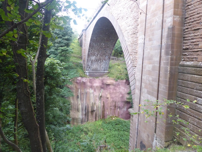
As I walked along the cliff top path I was joined, about 100 metres away by the busy A1 road and the main east Coast main rail line. When I reached Bilsdean Burn I had to lose all of my height and drop down to the shoreline, which was annoying. I carried along the shoreline for a while until I arrived at the huge Dunglass Dean ravine. The ravine is quite amazing and even though this was at the end of my walk and I was really tired this natural feature blew me away. Within a very small area there are four bridges, the closest to the sea is the current A1 dual carriageway bridge, then comes the old A1 bridge from 1932, then the railway viaduct and finally the bridge that I crossed over, probably the old coast road bridge. I walked underneath the first three bridges and picked up the Southern Upland Way. It was very difficult to get a photo that gave the depth and scale of the ravine, especially with the amount of summer foliage still around. After crossing the bridge I passed from East Lothian into the Scottish Borders region, my last in Scotland. All that was next required was a short walk into Cockburnspath.
A tiring day, but the legs were ok and I now looked forward to my final walk in Scotland.
Approaching Barns Ness lighthouseApproaching Torness Nuclear Power StationOld and new – the late 18th Century Torness LimekilnThe central shaft of Torness LimekilnHeading along the beach at ThorntonlochThe supports for the new A1 bridge over Dunglass Dean with the old 1932 A1 bridge to the rightThe railway viaduct over Dunglass DeanEntering the Scottish Borders
NB: I also publish all my Scottish Blog entries on the excellent Scottish Hills website, I use the same narrative, but larger photos and a few extra ones. They can be found here:
My third day of this walking trip and I have concerns about finishing the walk that would end in North Berwick. Yesterday my feet and lower legs ached quite badly which required me to stop five times to temporary rest them. As this was a Sunday I stayed with my tactic of walking very early towards my destination and then using public transport to travel back to my car. So at 05:00 I drove from my B&B in Leith to Prestonpans railway station where I parked.
As I set off from the railway station in the dark with head torch on, I felt my feet and legs to be perfectly ok. Even though today’s walk would be considerably less than yesterday’s walk I knew at some point the achy feet would come back.
The next 6 or seven miles would be predominantly on the John Muir Way, which also follows alongside the B1348 and both stick very close to the shoreline of the Firth of Forth. As it was still dark, my photos were very thin on the ground. I’m afraid I don’t have the skill or patience to set up my camera to take night time shots – I’m still basically a point and click sort of guy.
I passed out of Prestonpans and past the site of the former Power Station of Cockenzie, demolished some 5 years ago. By the time I reached Seton Sands the dawn had begun to break and I was able to switch off my head torch. I could still see the lights of the towns and villages across the Firth in Fife, on a lovely still morning. After passing Longniddry the coastline began to turn northwards towards Aberlady. As I rounded Aberlady Bay I left the road behind and headed across Peffer Burn via a wooden footbridge onto a vast expanse of land called Gullane Links. The links contain a number of golf courses and surprisingly the ground rises quite high here. I headed for the high ground, which gave an impressive view across to Fife, westwards to Edinburgh and to North Berwick Law and the surrounding area of East Lothian.
I purposefully headed into Gullane, a place I last visited some 46 years ago and a place where someone very special to me lived together with her family. As I stood and paused at the end of the road where they once lived I felt very sad. Distant memories.
As I left Gullane behind me the feet started to complain again, not painful, just ‘achy’ like they normally do after 10 miles of walking. I decided to stay on the road the remaining 5 miles to North Berwick. Although there is an excellent bus service running every 30 minutes, on a Sunday, back to Prestonpans I decided on catching the train; well I had parked the car at the train station in Prestonpans. North Berwick rail station sits at the end of a small single-track branch line which is linked to the main East Coast line. It has just a single platform and a waiting room, fortunately, there is a small booth where I could buy a coffee. I sat outside in the bright sunshine waiting for the first train of the morning. By 3’o clock that afternoon I was back home in my garden in Shropshire. Time to recover my achy body and feet and to plan the, hopefully, two walking days that will get me to Berwick-upon-Tweed
Early morning heading along the Firth of Forth just north of Seton SandsZoomed shot across the Firth to Kirkcaldy with both East and West Lomond on showWalking northwards along Gosford BayThe entrance to the grounds of Gosford HouseThe old Mercat Cross in Aberlady. Mercat Crosses represent a town or village’s right to hold a regular market or fairCrossing the Peffer Burn onto Gullane LinksZoomed shot westwards towards the Forth Bridges 22 miles awayZoomed shot across Aberlady Bay back towards Edinburgh from Gullane LinksLooking towards North Berwick LawThe ruins of the 12th Century Old St. Andrews Church in GullaneNorth Berwick railway station
NB: I also publish all my Scottish Blog entries on the excellent Scottish Hills website, I use the same narrative, but larger photos and a few extra ones. They can be found here:
I had based myself in a B&B in Leith for the two nights of this trip, at a fairly reasonable rate for city such as Edinburgh. I had already worked out how many miles I could clock up on two successive days of long distance walking, and decided that I should be able to reach Prestonpans today. Although after yesterday’s exertions I was a bit apprehensive about completing the distance.
I decided to drive to and park at the railway station in Prestonpans. I then caught the 06:26 train to Edinburgh Waverley, and then had a short walk to the end of Princess Street to catch the 06:57 #43 bus to South Queensferry. I got off the bus very close to where I had parked yesterday. Today was forecast to be a dry warm day with lots of sun, and so it turned out to be.
The old cobbled streets of South Queensferry were deserted when I walked along them and although a small place, seemed to echo a rich history. What I did have on this beautiful morning was an unobstructed view of the Forth Bridge (the railway one) and I decided that this bridge was probably my favourite bridge, it had close competition from the nearby Queensferry Crossing and a bridge, about 5 miles from my home – Ironbridge in Shropshire.
Today’s walk would follow off-and-on the John Muir Way. I followed a good track out towards Hound Point and then SE along Drum Sands. The surrounding forest soon gave way to the impressive Dalmeny House, home to the Earl and Countess of Roseberry. I cut across the private golf course and headed along the shore a small distance. Even at this early hour there were many people out and about, particularly cyclists. At some point I knew I would have to divert inland for almost 2 miles, as the River Almond crossed my path, making its way towards the Firth of Forth. After crossing the River via the old bridge close to the A90 I headed north. The walk along the banks of the Almond was brilliant, full of rapids, a weir and a gorge, the walk was beautiful. Eventually the Almond emptied into the Firth of Forth at Cramond. I always associate Cramond with the House of Shaws in Stevenson’s novel Kidnapped, and John Laurie (Ebenezer Balfour) appearing at the window with Blunderbuss in hand to confront his nephew, David Balfour.
The cobbled streets of South QueensferryThe Forth BridgeThe Forth BridgeDalmeny HouseHeading towards Leith along the Firth of ForthWeir on the River Almond near CramondThe River Almond flowing into The Firth of ForthThe low tide path out to Cramond IslandStranded fish on Cramond beach
The next section of the walk was along the Cramond promenade which was really busy with runners, walkers, cyclists, dog walkers and others setting off on the low tide towards Cramond Island. I did think about doing an out and back to the island, but with the long distance yesterday and still having a long way to go on todays walk I pressed on towards Leith.
The outer suburbs of Edinburgh began to appear, but I could see I was still some 4 miles from Leith. Eventually I passed the large marina developments of Granton Harbour and then onto the Port of Leith. The whole area is one of huge residential developments that are still ongoing. The busy road seemed to go on forever and I was glad when I lost the main road which had been with me for almost 4 miles now. I was rewarded with a glorious down onto the Portobello and Joppa beaches and the sweeping coastline of East Lothian heading towards North Berwick. I also began to see the appearance of road signs for Berwick-upon-Tweed; another reminder of the end of my walking journey around the Scottish coastline. The promenade in Portobello was crowded and I struggled to keep my social distance as I passed through the throngs. By the time I reached Joppa, I had taken 3 or 4 rests and my feet are starting to complain.
I pressed on and began to fade as the miles ticked on, by the time I crossed over the River Esk at Musselburgh I had taken my fifth rest, as I contemplated the fact that I’ve just crossed over into East Lothian, my penultimate County, with just the Scottish Borders still to come. I struggled into Prestonpans and slowly made my way up the hill towards the train station.
Another tough day of 8 hours walking, even though I stop 5 or 6 times the rests are not always helpful as it gets difficult to get the legs and feet moving again after stopping!
Granton Lighthouse – built in 1850 as a training lighthouse for the Northern Lighthouse BoardLooking down on the beaches at Portobello and JoppaBusy times on Portobello sea frontSilver Mussell sculpture at MusselburghCrossing the River Esk in Musselburgh
NB: I also publish all my Scottish Blog entries on the excellent Scottish Hills website, I use the same narrative, but larger photos and a few extra ones. They can be found here:
This could be my last 3 day walking trip to Scotland, as if all goes to plan I would reach North Berwick by the end of it, leaving two big walking days to Berwick -upon-Tweed, thus completing the Scottish section of my coastline walk around Great Britain.
Today’s walk would be a big day and I needed a very early start. To do this I had to get about 5 hours sleep the previous evening and then drive up to Edinburgh through the night. I planned to catch the 6:32 #x58 bus from the slip road on the Forth Road Bridge, this bus would go all the way onto East Wemyss. The drive up from Shropshire was quick, as travelling through the wee small hours usually is. I parked at The Binks, in South Queensferry and walked the half mile onto the slip road of the Forth Road Bridge. I was not surprised to hear the bus driver say it was £12.70 for a single fare to East Wemyss. That would have been the most expensive bus journey ever for me. However, on the Scottish Traveline site I had seen that a day return ticket would be just £8. I have still yet to understand why these fare pricings are what they are!
Five minutes after getting off the bus in East Wemyss, the rain started and within 10 minutes I was soaking wet. The heavy rain shower was not forecast, which made me a bit annoyed. At least the walking was easy as I passed below Wemyss Castle, along the shore side Fife Coast Path.
I soon came to the first real built up area which was the old mining community at Dysart and the long since closed Frances Pit. The only visible remnants of this mining town were the info boards and the old winding gear. I passed around its charming little harbour and through a small tunnel which led to the shoreline. I passed by the ruined Ravenscraig Castle and came into Kirkcaldy. The rain returned again and I received a second soaking. I decided to get some respite from the rain by popping into Lidl to get some pastries. The walk through Kirkcaldy was easy along the wide sea front promenade.
Dawn at The Binks, South Queensferry looking across to FifeLow tide at West Wemyss harbourLooking south down The Firth of Forth at Chapel Wood TowerThe old headframe at Frances Colliery, DysartSt. Serfs Tower and Church in DysartRock tunnel towards Ravenscraig at Dysart harbourLooking down on Pathhead Sands and Ravenscraig Castle
The sun eventually came out as continued south along the shoreline path into Kinghorn, here I had to divert inland slightly to get around the railway. Edinburgh was now becoming larger in my sights across the Firth of Forth as I followed the railway line into Burntisland. After walking through the town I re-joined the railway line along the Fife Coast Path. I passed along the steeply wooded area known as the Heughs, which displayed a number of recent landslides, with evidence of a small foot bridge being swept away. The next small town I came to was Aberdour which seemed to contain a number of “private” streets and looked to be “very well to do”. Here I had to divert inland to get around an oil terminal to the south, alongside a golf course.
The rain returned again as I entered the really posh areas of Dalgety Bay, fortunately I had not dried out from the last deluge so I did not get as wet this time. I could now make out the three bridges quite easy, as I left Dalgety Bay behind and pushed on into Inverkeithing. I was now beginning to feel the effects of the long drive and the equally long walking mileage. I decided to give North Queensferry a miss and head straight for the Forth Road Bridge. I was now getting slightly nervous now as the wind speed had been building for a while now, although, I was sure the speed was less than the 50mph it needed to be before pedestrians were not allowed on the bridge.
By the time I reached the approach to the bridge warning signs had restricted the Queensferry Crossing (the Motorway Bridge and which I had walked over back in 2017) traffic to 40 mph. The speed on the Forth Road Bridge was a more sedate 20 mph, which the permitted traffic of buses, taxis, motorbikes obviously were not adhering to. It was certainly a unique setting to have these great bridges grouped so closely together. As I walked over the bridge I was surprised at how low the perimeter guard rail was and the huge drop to the water below. The length of the bridge is just over 1.5 miles long and I was really pleased to finally reach the far side. After crossing the bridge all that remained was to complete the short walk back down to South Queensferry and my car. I had been walking for 9.25hours and I was quite fatigued.
Seafield Tower between Kinghorn and Kirkcaldy, abandoned in 1733Looking down on the sea front at KinghornZoomed shot down The Firth of Forth to the three bridges. Notice the wind speed has picked upZoomed shot across the Firth to Arthurs Seat, Salisbury Crags and LeithHeading into BurntislandLooking down on The Hawkcraig Point Leading Lights marking the deepwater channel from the east end of Mortimer’s Deep to the Forth Deepwater Channel, used by LPG tankers leaving the nearby Braefoot oil terminalThe ruins of St Bridgets KirkIn the late 18th and early 19th cenbtury this small stone building adjacent to the kirk graveyard was used by relatives watching over the graves to ensure body-snatchers did not steal those recently buriedLooking across to the Queensferry CrossingLooking back to the Queensferry Crossing from the Forth Road Bridge
NB: I also publish all my Scottish Blog entries on the excellent Scottish Hills website, I use the same narrative, but larger photos and a few extra ones. They can be found here:
The final day of another three day walking trip and I was keen to make a very early start for today’s walk. I was up at 3:30 and after packing, making a cup of coffee and consuming a bowl of muesli I set off for East Wemyss. As this was a Sunday morning I had something like 4 hours before public transport started running, so during these 4 hours I could get something like 12 miles under my belt.
I parked in a free car park on the shore front in East Wemyss and set off. It was still very dark and I needed to use my head torch to follow the path. I could see the early morning glow in the east, but would need my head torch for a while yet. I immediately came upon a series of caves. I had never heard of these caves before, but on returning home and doing some online research I read that they were created 8000 – 5000 years ago by wave action. They were inhabited over 4000 years ago and have a high number of carvings inscribed on their walls. The earliest of these are thought to date to the Bronze Age, whilst the vast majority are connected with the Pictish period. It was much too dark to venture into the caves, but on my next visit I’ll try and remember to have a look around them. In my research I also found out the correct way to pronounce Wemyss – or should I say “Weemz”? The footpath rose up from the shoreline to a cliff top path where I passed the ruins of Macduff’s Castle.
By the time I reached the small town of Buckhaven I was able to switch my head torch off. This part of the northern of the Firth of Forth has many small villages and towns with a rich history of both fishing and coal-mining. The next 3 or 4 miles would be along the deserted residential streets of Methil and Leven. Because of the Fife Energy Park and the old docks it was difficult to gain access to the shore.
Far too dark to take photo’s with my camera but the shape of Macduff’s ruined castle gives an eerie feelWalking along the promenade at Leven
I found numerous dead Starfish on the beach near Leven, sensitive to pollution Starfish are also vulnerable to certain viruses that can destroy their communitiesHeading along Largo Bay with Largo Law in the distanceRobinson Crusoe statue on an house in Lower Largo, birthplace of Alexander Selkirk
After crossing over the River Leven into Leven itself I was able to join the promenade which ran for some distance along the huge swinging shoreline of Largo Bay. I soon left Leven and the large industrial areas behind me. I passed through the small town/village of Lower Largo, famous for being the home of Alexander Selkirk, the original Robinson Crusoe from Defoe’s classic novel. His 1885 statue adorns the side of a house on the site of his original birthplace in the village.
Ahead I could see the distinctive hill of Kingcraig Hill, which I was aiming for. Unfortunately I had forgotten about the Elie Chain walk, which is situated just to the west of Elie itself. I had made a mental note to have a go at the Chain walk some time ago – school boy error or just old age? I crossed the golf links into Earlsferry which adjoined the village of Elie. I followed the route of an old railway line and passed by the old ruins of the 14th Century Ardross Castle. As I approached the small village of St. Monans I passed the much better preserved 13th century Newark Castle and nearby dovecote.
The next village I would come to was Pittenweem, infamous for its witch trials and the lynching of Janet Cornford. At this point i realised I was running short of time to catch my bus back to Leven and East Wemyss, so I took to the main road and continued at a fast pace onto Anstruther.
From the lack of narrative in this report you can see that I rushed this section, although it did not appear so at the time. Fife is certainly a very interesting place to visit and possesses a great coastal path to walk along, plus lots of interesting history. Only 5 more days of walking in Scotland.
A zoomed shot across the Firth of Forth twoards EdinburghLooking across Elie HarbourLadys Tower – built in 1770 for Lady Janet AnstrutherThe ruins of Ardross CastleThe ruins of Newark Castle near St. MonansHeading into St. MonansLow tide at St. Monans harbourLooking down on Pittenweem
NB: I also publish all my Scottish Blog entries on the excellent Scottish Hills website, I use the same narrative, but larger photos and a few extra ones. They can be found here:
I had based myself in the market town of Cupar which is situated roughly in the central part of Fife, this made it quite easy to drive to and from each walk.
This morning I felt like the “Elephant Man” with two rather swollen bumps on my face from the yesterday’s Cleg bites in the Tentsmuir Forest. I set off early from my B&B in Cupar to drive the 16 miles to Anstruther. Here I parked up and walked down to the harbour where I caught the 7:06 # 99 bus to St. Andrews. I decided to sit on the top deck at the front which gave some brilliant views of the coastline. At St. Andrews Bus Station I had a short wait before catching the #42 bus for the short distance to Guardbridge.
It was a gorgeous sunny morning when I set off from Guardbridge. I quickly made my way back into St. Andrews. I could have cut across 3 golf courses to make a b-line for St Andrews beach, but decided against it as the courses where very busy. I did pay a great deal of attention to the 17th & 18th holes of the Old Course as I had seen them countless times on the TV, but seeing them in the flesh was much better. I used to be a keen golf player up to 1998, I even got my handicap down to 12, but for a number of personal reasons I packed the game in. I slowly moved on past the Castle and Cathedral. By the time I reached the outskirts of St. Andrews I had taken up a great deal of time and I still had a long way to go.
Looking across The Eden Estuary towards RAF LeucharsLooking up the 18th Hole on the Old Course at St. AndrewsCrossing over The Swilken Burn at St. AndrewsLooking northwards along St. Andrews beachThe Martyrs Monument St. AndrewsSt. Andrews CastleThe letters “G” “W” embedded in the street mark the spot where George Wishart was burned alive.The foundations of the Church of St Mary on the Rock
I followed the Fife Coastal Path, for most of the way, but opted to walk across sandy beaches where the path allowed access down to the beach. With the tide well out I could this easily do this. I had fantastic views to the north with the Angus and Aberdeenshire coastline visible almost to Stonehaven. I came across Buddo Rock , an amazing old sea stack situated on a raised beach and displaying fantasic weathered shapes in its Old Red Sandstone. At Boarhills, for some reason, The Fife Coast Path cut inland. This was due to Kenly Water, which I later discovered could could be crossed quite easily on the beach at low tide. The inland detour was still amazing though because I got to do the riverside walk alongside Kenly Water as it made its way through the gorge that it created down to the sea.
The walking got easier once I was back on the coastline. The appearance of a refreshment shack at the car park near Kingsbarns was a welcome relief. I bought 2 cold drinks and a hot dog at rip-off prices, the hot dog was appalling, but I ate it because I nothing else to eat. About 2 miles down the coast I a bit of a breather and carried on for about 15 minutes only to realise I’d left camera on a rock almost half a mile away. I really didn’t need the running back to retrieve it, as my legs were already beginning to tire.
With my camera now safely back in hand I reached the most easterly point on Fife – Fife Ness. The panoramic view that greeted me to the south was simply amazing and brought home to me how close I getting to completing the Scottish section of my walk around Great Britain’s’ coastline. To the immediate south I could see the Isle of May and could also see the Berwickshire coastline stretching all the way down to St. Abbs Head. To the South West I could also make out across the Firth of Forth the Bass Rock and to the right of that I could see North Berwick Law.
I limped in to the small fishing village of Crail, similar to some of the Cornish fishing villages that I had passed through some years ago. Crail was very busy, but for me it was now tough going. I knew I only had about 3 more miles to go before I reached Anstruther. The sting in the tail was two-fold, the first sting was the sun had disappeared behind the clouds about an hour ago and a small sharp shower arrived which drenched me. The second sting was that on reaching the outskirts of Cellardyke, Anstruther was still a kilometre away.
Overall, this was a fantastic days walk, but it had taken a lot out of me again, as I been on the go for another 8 hours. I hope tomorrows walk is not that long again!
Looking back at St. AndrewsHeading along the Fife shorelineHidden steps into Buddo RockThe old sea stack of Buddo RockConstantine’s Cave at Fife NessLooking down on Crail HarbourThe Isle of MayCaiplie CavesThe Bass Rock
NB: I also publish all my Scottish Blog entries on the excellent Scottish Hills website, I use the same narrative, but larger photos and a few extra ones. They can be found here:
With almost an end in sight to my walk around Scotland, I wanted to get at least another 3 days walking in before the month end. I was also slightly concerned with the possibility of a local lockdown in the Borough of Telford & Wrekin due to a sharp spike in covid-19 cases within the last two weeks. Fortunately, the Health Trust was only warning of a possible lockdown, so I managed to get away, although it could still happen over the next few weeks. I wanted to get a full days walking in on the first day of this trip which meant I would have to do all of the travelling through the early hours, so it was very early to bed the night before.
I found a parking spot in Guardbridge, where my walk would end on the first day. I caught the 08:32 #99 bus to Dundee and then the #73 bus onto Monifieth. The forecast for today was not good with light rain and showers all day. In fact the day started off very bright with not a cloud in the sky that was until I stepped off the bus in Monifieth when the rain started! Today I would be starting in Angus and then walking through Dundee City and then crossing the Tay Bridge into Fife.
At Monifieth, I made my down to the banks of the Tay. The far shore of the Tay is dominated by the low lying Tentsmuir Forest and the small town of Tayport. I could see the heavy rain squalls coming up from the south, so I put my waterproofs on. The rain was quite heavy and continued unabated for over two hours. I managed to stay on the cycle/footpath all the way into Dundee, after passing through Balmossie and Brougthy Ferry.
The persistent rain meant I kept my camera dry beneath my walking jacket. By the time I reached Dundee City I was soaked to the skin! I was also worried about high winds which the motorway matrix signs had warned about on the drive up. But the Tay Bridge was only closed to pedestrians should the wind strength reach 60mph! Fortunately, we were not expecting those sort of wind speeds.
Because I stayed quite close to the shore I did not see a lot of Dundee itself, the rain saw to that! I did notice as I walked into Dundee that the Tay Bridge had a noticeable gradient on it, being 32.1m above sea level on the Fife side and 9.75m on the Dundee side. I was looking forward to crossing over the Tay Bridge on foot. It’s quite a unique experience for pedestrian as you are sandwiched between the two dual carriageways on an elevated central walkway, just a few feet from both opposing fast lanes. You can also see that you are walking uphill as well!
Heading westwards towards Dundee at MonifiethBrougthy Ferry CastleLooking towards the Tay Bridge with its gradient very apparentJack-up drilling rigs in Dundee DocksUnderneath piling supporting The Tay BridgeHeading up the slope towards Fife on the Tay Bridge
By the time I reached the far side I had passed out of Dundee City into The Kingdom of Fife. On the Fife side was a large car park with toilets (closed), Info Point and small take-away cafe which was serving food. I bought a bacon and sausage bap and a latte – they both tasted horrible, but the rain had stopped and the sun was just coming out!
I was now on the Fife Coastal Path and would continue on it until I reached the Forth Road Bridge. I followed the well-marked path into the small town of Tayport or to give it its old name Ferry-Port on Craig, now a commuter settlement for Dundee City.
Soon after Tayport I was heading towards a large forested area called Tentsmuir Forest which is also a large National Nature Reserve. I headed eastwards towards Tentsmuir Point and eventually turned south following the line of the trees. I re-joined the forest road which was quite straight and boring, seeming to go on forever. I passed one of a few ice houses, which were used for preserving the ice for the salmon fishing. Although initially built on the coast in the mid-19th century, the sea had retreated quite a way leaving these ice houses marooned in the forest. I was plagued virtually the whole time walking through the forest by Clegs, Gadflies or Horse-flies. Later that evening I found I had been bitten twice on the face by these little b***ers.
I eventually reached the large public car park, where I managed to buy a can of pop to supplement my water supply. The next 3 miles seemed to drag on forever as I negotiated getting around the large RAF base at Leuchars. I did manage to follow one false trail which lead me deeper into the RAF base, before I realised I was on the wrong path. I was really glad to see Guardbridge arrive as I had been walking for 8 hours and had really under estimated how long this walk would take. I passed the old Eden Mill, which is now partly used as distillery for my favourite Gin tipple of Eden Mills.
A good day’s walk spoiled for the most part by the weather, which did improve in the afternoon. Although the definite highlight was the walk over the Tay Bridge.
Looking back towards The Tay Bridge and the City of DundeeTayport East lighthouseHeading towards Tentsmuir ForestAt Tentsmuir PointIce House in Tentsmuir ForestEden Mills at GuardbridgeThe old railway bridge supports across the River Eden at Guardbridge
NB: I also publish all my Scottish Blog entries on the excellent Scottish Hills website, I use the same narrative, but larger photos and a few extra ones. They can be found here:
This was my final days walk on this particular trip and overall it had been a successful 3 days so far. I decided to reverse my direction of travel for this particular walk as I would be heading south when I finished. It was also Sunday morning and the first bus service did not run before 8:20. With so much daylight available at this time of the year and the advantage of walking in the cool dawn of the morning, I opted for an early start. I was up and away from my hotel by 4 and by 4:45 I had driven to and parked up in Monifieth, on the outskirts of the City of Dundee. Sunrise was still 50 minutes away, but it was light enough to walk. I could now make out Fife to the south and in the distance could see the lights of St. Andrews.
Virtually all of today’s walk would be along flat roads, lanes and footpaths and in a straight line. Almost immediately after setting out I joined the huge military firing range to my right, which occupies most of the Barry Links promontory. I had awoken early this morning to find that the temperature had dropped by quite a bit and as I followed the tarmac path I could see low lying mist just a few metres above the ground. As the footpath rose and fell by just a few metres I could feel still feel the cold temperature change as I descended into the dips of the path.
I emerged on the far side of the firing range at the outskirts of the large and famous golf links at Carnoustie. I continued alongside the railway line and out of Carnoustie. I had not seen a soul all morning, but eventually a few other walkers appeared out of the mist. By the time I reached the old fishing village of East Haven I was immersed in a large fog bank which reduced visibility to less than 100m. East Haven seemed to be filled with all sorts of statues and information boards. One board in particular caught my eye. It featured an old photograph of, presumably, the whole village lined up near the shoreline, to have their picture taken in 1870.
Very early morning joining the Firing RangeThe large hotel at Carnoustie Golf linksLooking back south at CarnoustieInfo board at East HavenHeading northwards into fog bankLooking back southwards near Arbroath
The fog had lifted when I entered the outskirts of Arbroath giving a bright sunny day. I stayed close to the promenade along the West Links. I passed behind the football ground, Gayfield Park, of Arbroath FC and continued onto the large white building of the Signal Station. The Signal Tower was the shore station and family accommodation for the Bell Rock Lighthouse, built in 1813, 11 miles off-shore, but is now a free entry museum. As I walked around the harbour I kept an eye open for a place to buy a pair of Arbroath Smokies. Unfortunately, on a Sunday morning and still being quite early, I found none of the shops open. I decided that I would order them online, as I particularly like smoked fish.
I began to leave Arbroath behind and carried along the long sweeping Kings Drive through Springfield Park. Where the drive finished I continued on along a tarmac footpath. The appearance of Devonian Old Red Sandstone cliffs was quite dramatic with bedding lines, weathered joins, caves and sea arches giving interesting shapes and forms to the rocks. At Carlingheugh Bay, I followed a signpost to the village of Auchmithie, which took me down to the shoreline and then back up the steep cliff, an unnecessary route from what I could see. I followed the path around a huge set of fields containing polytunnels. Near Tanglehall cottages and in a field of Brussels sprouts I found Gaylet Pot a large blow hole, which could be climbed down with care. This is a video I found on You Tube, although there are others.
I continued on in to the small village of Auchmithie. This former fishing village was where the Arbroath Smokie (Haddock hot smoked) originated.
I left Auchmithie and followed an old coast road north, before beginning to make my inland towards Inverkeilor to pick up a bus back to Monifieth.
The Signal Station and Museum in ArbroathLooking back at ArbroathOld Red Sandstone at Needle E’eNesting KittiwakesLooking towards Carlingheugh BayGaylet Pot near AuchmithieAuchmithie
NB: I also publish all my Scottish Blog entries on the excellent Scottish Hills website, I use the same narrative, but larger photos and a few extra ones. They can be found here: