63. Conwy to Bangor

Today I would be continuing on from where I completed a short section of the WCP some 2 years previously as part of a charity walk.

I parked in Bangor at a free car park off Beach Raod and walked back into town to the railway station. I caught the 08:02 to Conwy and as this was a request stop I had to ensure the conductor knew I wished to alight there (I had had already bought my ticket at Bangor). The train was bang on time and by 8:20 I was walking towards Conwy Castle.

Walk631
Conwy Castle

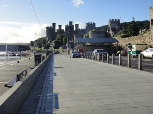
The weather this morning was beautiful and sunny, with hardly a breath of wind. I walked along the quay, passing a house reputed to be the smallest in Britain. Also known as Quay House, it was lived in until 1900.

Walk632
Quay House

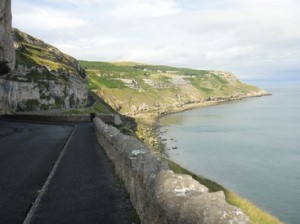
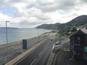
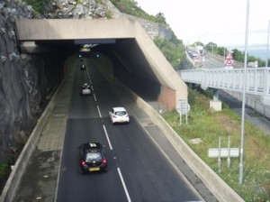
I pass a new built marina development, before crossing the A55 for what will be the first of many times today. The path swings out towards the Conwy estuary before turning west following Conwy golf course before re-joining the A55. The A55 or North Wales Expressway, will be with me for most of my journey today. Where I re-join the A55 the road passes through its second tunnel, (the first was under the Conwy River). This second tunnel, called Penmaenbach, is a wonderful piece of engineering, where road, rail and footpath vie for space around the rocky headland, that juts out right to the sea. The west bound carrigeway has its own double lane tunnel, while the east-bound route clings to a rocky ledge together with the WCP. The railway has its own tunnel. The whole process is replicated a few miles up the road at the third tunnel, the Pen-y-Clip.

Walk633
Looking east along the A55 from Penmaenmawr

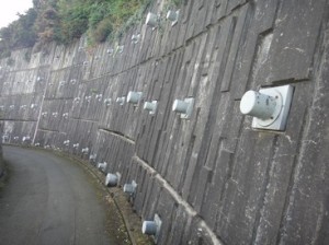
I proceed around Penmaenbach and carry onto Penmaenmawr where the WCP crosses and re-crosses and crosses again the A55 by a complex series of bridges. I emerge around the headland of Pen-y-Clip and head down into Llanfairfechan. Anglesey, meanwhile, has got considerably closer and I can make out the small town of Beaumaris just across the Menai Strait.

Walk634
The Pen y Clip tunnel

After Llanfairfechan the path gradually moves away from the A55 and it is nice to have a bit of piece and quiet. At Aber Ogwen the WCP makes a large inland detour to get around the National Trust property of Penrhyn Castle. I will not get back onto the coast until I enter Bangor and I feel rather aggrieved that the NT does not allow the path to follow the shoreline……I am a member you know! The walk around Penryhn is made easier by the availability of some lovely tasting roadside blackberries. I rejoin a main raod into Bangor, which has a good footpath

Walk635
Rock anchors , with sensors attached

I complete the 18 miles in 5 hours.


Distance today = 18 miles
Total distance =   940.5 miles

62. Rhos on Sea to Llandudno Junction

Quite a shortish walk today, while trying to take-up from where I deviated inland on my charity walk which involved a complete tour around the periphery of Great Orme.

Walk621
The view towards Llandudno and Great Orme from Little Orme

I parked up in Llandudno Junction and caught the 7:18 bus to Rhos on Sea. The driver was a bit unsure of the route, but we managed to get where I needed to be and I began walking at 7:50 on a beautiful summers morning. I started opposite Rhos on Sea Golf course and continued along the promenade towards an housing estate. These houses sit below The Little Orme, the little brother to Great Orme. Although, the WCP goes over Little Orme, it did not visit the summit. With only a small deviation I opted to climb through the old quarry workings to get to the top at 141m. The view was well worth the effort with great vista down to Llandudno and the Great Orme and Anglesey. I descended down steep slopes and back-tracked a bit to get on the road. The remainder of the walk would now be totally on tarmac.

Walk622
The Toll Road

I followed the promenade along to the peer. I noticed a number of statues depicting Alice in Wonderland characters. Apparently, there is no concrete evidence that Lewis Carroll ever visited the town and the association seems rather contrived.

Walk623
Feral Goat

I was looking forward to the next section which involved taking the Toll Road (aka Marine Drive/ Happy Valley) around the outside of the Great Orme. Although the toll is still charged for those with vehicles, pedestrians can walk free. The bulk of the Great Orme is made up of Carboniferous Limestone, which exhibits fantastic bedding structures and fossil remains. The road clings close to the cliffs and gives the place a feeling of a corniche in the south of France. I pass a few white feral goats, they seem oblivious to my presence. This perimeter around the Orme operates on an anti-clockwise one-way system. About half-way to the Great Ormes Head, another road descends from the summit, through twisty zig-zags. The traffic is very light at this time of the morning, so I can relax and enjoy the views out to Liverpool Bay.

Walk624
Great Orme’s Head

At Great Orme’s Head there is a lighthouse and a cafe – The Rest and Be Thankful. The cliffs at this point are very dramatic and host a number of bird colonies. I can now see across to Anglesey, with Puffin Island in the foreground. I can also make out Bangor in the far distance. The road and footpath begin to descend slowly with views now opening up towards Conwy,  I can just make out the Castle.

Walk625
Looking towards Conwy Castle from Deganwy

I pass a shelter with a bench inside. The shelter has been built in memory of a young lad, Blair Gow (aged 16) who died while walking in the Welsh mountains. There are some poignant words on the wall in the shelter. I do not linger as the stench of stale urine, seems to desecrate the place.

The path moves down to Deganwy and follows the estuary close to the railway line back to Llandudno Junction. I take a leisurely 4 hrs to cover the  13 miles.

Distance today = 13 miles
Total distance =   922.5 miles

61. Prestatyn to Abergele

A very short walk today, as I needed to tie in with my Charity walk the previous year. I decided to bring one of my three dogs along, Kiefer-Slash, (the wife named him thus), he’s a sort of Spaniel cross. He had never been to the seaside before, so I was wandering how he would react. He stayed on the lead virtually the whole walk.

Walk611
Kiefer-Slash in Prestatyn

The walk in a nutshell was simply walking along a long promenade linking the two towns. We had views out to the gas fields offshore. This whole part of the North Wales coast I find really ‘tacky’ and run-down. I can find no redeeming features about the place other than it is flat and has good transport links.

Walk612
The Rhyl Lifeboat being pulled ashore

We drove to and parked at Abergele & Pensarn station. We then caught the train for the 8 minute ride to Prestatyn. Kiefer was excellent on the train.

Walk613
The Pont y Ddraig at Rhyl

We walked down the main street towards the beach. Kiefer did not know what to make of the small waves lapping on the shore. He was also very wary of seaweed for some reason. The rest of the walk was him sniffing around, as dogs do, or maybe he was just as unimpressed of the place as me!

Walk614
Looks like a tribute act for Richard Nixon

We soon came to Rhyl, which was just like Prestatyn. We crossed the recently constructed pedestrian and cycle  footbridge called Pont y Ddraig – Dragons Bridge. The footbridge cost £10m and can be raised for boats.

Just outside Rhyl we come across an ASDA trolley dumped in the sea – just about sums it up for me.

It took 3 hours to walk the 8 miles, which is really quite pedestrian for me. If Kiefer had been off the lead then perhaps we may have been quicker.

Walk615
Kiefer examines some Sea Holly


Walk616
My lasting impression of this section of the coast


Distance today = 8 miles
Total distance =   909.5 miles

60. Flint to Prestatyn

This was to be the second walk of the Wales Coast Path for and appeared to be a very straightforward section requiring just to stick close to the coast.

walk601
Flint Castle

I parked at the free car park just next to the castle in Flint and started walking north-west. This part of the Flintshire coast is littered with old industrial ruins, most being old docks and quays that served the local hinterland and bigger towns such as Liverpool. Flint Dock was one such place and is now just a relic of a time gone by. The path goes along the substantial seawall which runs all the way to Bagillt, at which I come across the Bagillt Beacon, a metal dragon sculpture housing a brazier which is lit on special occassions.

At Greenfield Dock I find an information board telling me how the Airbus A320 wings, which are made further up river at Broughton, are shipped down the Dee to the working port of Mostyn on a special barge for onward transport.

walk602
The Duke of Lancaster
walk603
John ‘Jack’ Irwin

The weather has remained cool and overcast which has enabled me to make good time on the flat terrain. I then come across the highlight of the walk, the beached ship The Duke of Lancaster. This was amongst the last passenger-only steamers built for British Railways in 1956. The ship had been there since 1979 and has quite an interesting history particularly surrounding how or what ‘she’ will be used for. The ship is covered with graffiti, some good, some bad. My favourite piece of artwork is a picture of the ship’s first captain, John ‘Jack’ Irwin. The ship is berthed at an old quay and is fenced off with barbed wire. The WCP skirts inland to the main road road to get around the quay.

On arriving at Mostyn Docks the path follows the main road which has a good footpath running alongside it. At Ffynnongroyw the A548 splits into a dual carriageway and I am directed off through the small village and eventually emerge at the A548 again which requires care in crossing both lanes. The path emerges at a sewage works and I cross the main railway line by means of a bridge. I am now amongst the overgrown roads of an old derelict industrial site, which sits next to a fully operational gas terminal.

walk604
The Point of Ayr lighthouse

The path enters the Point of Ayr Nature Reserve which culminates in the road end at Talacre. I am suddenly surrounded by beach-goers who are enjoying the mid-afternoon sun. I round the Point of Ayr and pass the lighthouse. I am now heading into quite a stiff breeze, which will be head-on all the way to Prestatyn. I can also make out parts of the North Wales including a distant Great Orme. Prestatyn is also busy with holiday-makers and I quickly head up the main street to the station to catch the usually frequent train service back to Flint. However, not today as the train is delayed by 40 mins due to the knock-on effects of a tanker fire on the M56. I also get the double-whammy of huge congestion at Chester on my drive back on the A55. Walked about 18.5 miles in 5.5hrs.

Distance today = 18 miles
Total distance =   901.5 miles


59. Lynton to Minehead

My final day walking the South West Coast Path! It was going to be a long one and as I wanted to finish early I made a very early start. I parked up in Lynton and began walking at 5:40. It was light but cool and overcast, my ideal walking weather. Lynton was very much still asleep as I climbed up towards Countisbury Hill with the path running close but just below the main road.

walk591
Looking back at Lynton from Countisbury Hill

I look back towards Lynmouth which is bathed in a sea of alpenglow from the early morning sun. The path passes over The Foreland with its lookout shelter and I descend with the path and maintain my height when the path contours in and out of each small coombe.

walk592
Culbone church

I enter a wooded section that Iwill be in for about 3 miles. There is little to see along this wooded section as I take the preferred lower SWCP path route. Not too sure why they have an alternative route here. At Coscombe I pass Sisters Fountain, a small spring beneath a man-made cairn and a rough-hewn slate cross. I know from my maps that I have now crossed the county boundary, where I say goodbye to Devon and hello to Somerset, the county I will finish my walk in.

I am now in Culbone Wood, with the path gently rising up and down. I decide to visit the smallest complete parish church in England. Culbone Church, or to give it it’s proper name St. Beuno’s is a beautiful little church and well worth the detour.

walk593
Getting closer!

After passing through Worthy Wood I drop down off Porlock Hill to Porlock Weir. I pass some cottage’s with their occupants cooking breakfast. My tummy rumbles when I get the smell of bacon frying.

The next three miles will involve walking across the flat marshy area of Porlock. There are a number of opportunities to take your own route across this area, although i play it safe and follow the official route which skirts in land across a few fields. I pass a memorial to a WW2 aircraft crew that lost their lives after their Liberator bomber struck Bossington Hill and came down in the marsh.

walk595
Finished!!

It had decided to rain for a short while as began my final climb on the SWCP up onto Bossington Hill and Selworthy Beacon. I noted a newly constructed sign that advises me that Minehead is just 5 miles away. As I pass over Selworthy Beacon the sun comes out, surely an omen? The path gradually loses height gently off Selworthy, zig-zagging down a well made path. I emerge onto a tarmac path and pass the small harbour. The iconic sculpture of hands holding a map which mark the start/end of the SWCP comes into view. I arrive at the end 7 hours after setting off from Lynton. As when most great challenges are complete a small sense of deflation sets in mixed with relief and a sense of achievement. I ask a chap passing to take a photo of me at the finish. I walk towards the clock tower at Minehead, noting that I have just begun walking the West Somerset Coastal Path!

walk596
Its not over yet. Another journey, another day
walk598
The expensive ride back

I walk into Minehead and go a couple of pints of Doom Bar at the Wetherspoons as I have about an hour to kill to cathc my bus back to Lynton. The bus arrives and I am amazed to see it is a vintage bus from the 40’s/50’s. The bus takes the scenic coastal route because it cannot make the steep hill at Porlock. The scenic route does involve some tight corners which the bus has to reverse back for. I was also amazed to have to pay £10 for a return ticket, as single fares were not available! Hmmmm!


walk59a1
Vintage bus

Overall, I thoroughly enjoyed the SWCP. I had visited many many places I had never seen before and perhaps never will again. My favourite section had to be Cornwall.

Distance today = 21.5 miles
Total distance =   883.5 miles