After completing the walk to Red Point the previous day, I was then left with a small gap between Lower Diabaig and Inveralligin which I would now close.
On OS maps there is path indicated which links Diabaig with Inveralligin via extremely rocky and rough ground. I knew from reading previous walking reports that the path was notoriously difficult to follow, especially at the start. While I was in Diabaig yesterday I spoke to two locals who advised not to use the path. One of the locals went up the previous week but could not find its continuation after climbing onto a ledge. I had a quick look myself but could also see no continuation, I decided then to simply take the longer and higher road option via the Bealach na Gaoithe. Looking back this was a bit lazy of me, I should have explored more to try to get onto the track.
Anyway, I drove in the dark to Alligin car park and set off on my bike in the pitch dark. I was rewarded with a great stellar display as well as a number of shooting stars. By the time I reached the top of the Bealach na Gaoithe I could switch my head torch off. As I would be shortly walking back up to the bealach I was able to cycle down to Diabaig scattering a small group of young stags in the process.
Not much to say about the 7 mile walk back to the car, other than I got amazing views, only 1 car passed me, it was very quiet and still and very enjoyable.
After arriving back at car I drove back to the campsite to pack up my tent. I spoke to a couple of other campers, who were to do a bit of climbing in Diabaig. Apparently, it’s a very popular climbing area, which was news to me. They confirmed the walkers path, but mentioned about the difficulty at the start. Anyway, it was good get away early, as the 500 mile drive home beckoned. Hopefully, I will be able to get a few more days in Scotland before Christmas.
Setting off from Lower DiabaigHeading up to the Bealach na Gaoithe with Tom na Gruagaich in the distanceLooking down on the double lochs of Loch Diabagas Airde and Loch a’ Mhullaich from the Bealach na GaoitheWhere I should have emerged if I had taken the elusive footpath to Inveralligin Shuas
NB: I also publish all my Scottish Blog entries on the excellent Scottish Hills website, I use the same narrative, but larger photos and a few extra ones. They can be found here:
I decided to skip ahead for the next section as it was to be a longer walk and would enable me to finish my walk sooner on my final day. This section also provided a significant challenge in terms of getting back to my starting point. Basically I would be walking between the ends of two public roads with neither linked by any public transport over an open moorland footpath unsuitable for bicycles. I was left with only two viable options either I could do an out-and-back to Craig Bothy (some 4km away) from Lower Diabaig and then do the same from Red Point on my next trip to the area OR I could simply do an out-and-back between Lower Diabaig and Red Point. I chose the latter preferring to get the section done and out of the way. Fortunately, there have been very few places over the years where I have had to double back in order to complete a section.
The first night at the Torridon campsite was extraordinary windy, with the tent threatening to take off with the onset of sudden and violent gusts. It made for a troublesome and disturbed nights sleep. The wind was still there when I returned from my walk, even though 300m away there was little or no wind.
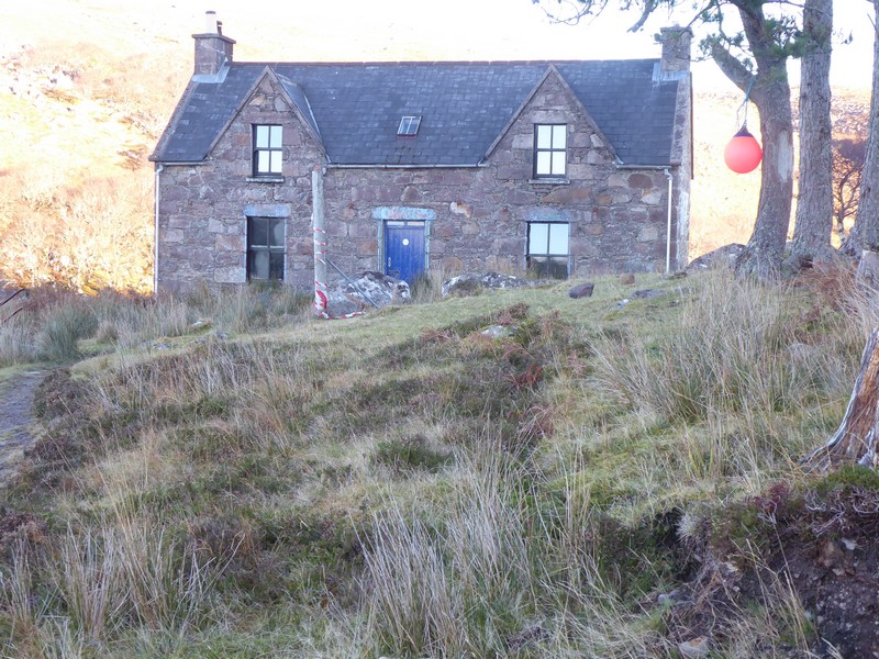
I set off from Lower Diabaig just as it was getting light. Lower Diabaig is a very tucked away hamlet at the end of a tight, steep and winding road from Torridon. The final descent into Diabaig was very steep and I would not fancy travelling down it in icy conditions. I parked up at the small sea front. This walk would be virtually all over moorland footpaths, but I still had about 1 km to walk up a very steep access road to get to the start of the path. I decided to push my bike up the hill to the start of the path and then chain it to a post. The bike would make the return journey down the hill back to the car very quick.
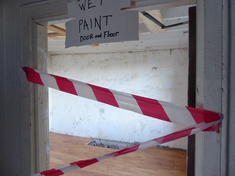
With the sun up and a beautiful cloud-free morning I set off on the first leg of the walk which would see me head for Craig’s bothy. The footpath out to the bothy was excellent and a pleasure to walk along. It was well-drained and often used bedrock, where it was close to the surface. I made good time to the bothy and decided to have a look inside. Surprisingly, checking the bothy book it had not been used for over a week.The most recent occupants had been a bothy work party who had completed some structural work to the floor on one of the lower rooms. This ex-YHA was in excellent condition and was spacious too, with 2 large and 1 small bedroom upstairs, together with the downstairs lounge (with offset kitchen) and a recently renovated room (temporarily closed).
Setting off from Lower DiabaigLooking across Loch Torridon to Rubha na Fearna (tip of Applecross), North tip of Rona and Trotternish on Skye in the distanceLooking north towards Red PointDescending to Craig’s bothyCraig’s bothyBothy loungeRecently renovated room
The second leg of the walk from the bothy on to Red Point was along a path that was not 20 good. After crossing the nearby Craig River via a wooden footbridge, the path followed the river bank until the coast before heading north along the coast. Although the path was easy to follow, it was poorly drained and meandered quite a bit. About half way along the path I met a couple who were heading to the bothy. I thought they meant to stay the night, but I met them again on the trail later on my return from Red Point.
Eventually I arrived at the old fishing station. Here the ground became very grassy,helped by sheep and cattle grazing, a small sandy beach was close by with people walking along the shore. I walked through Red Point Farm and onto the car park at the end of the public road………………and turned around. Although it was still only 13:30, it was along way back, but with a cloudless sky I knew I would make it back to Diabaig before 16:00 and the sun going down.
I popped into the bothy again on my return to enter some details of my visit into the bothy book. I made good progress along the good footpath and arrived back at Diabaig just as the sun was dipping below the horizon.
Approaching the old fishing station near Red PointAt Red Point car parkHeading south towards the old fishing station on the return legLooking north back towards Red Point from above Craig’s bothyLate afternoon sun back at Lower Diabaig
NB: I also publish all my Scottish Blog entries on the excellent Scottish Hills website, I use the same narrative, but larger photos and a few extra ones. They can be found here:
This was to be a three-day trip in which I hoped to get to Red Point and to take advantage of some unseasonably warm and mild weather. I tried in vain to locate some reasonable and affordable accommodation in the Torridon area but had no joy. I decided therefore to make use of the free campsite situated next to SYHA in Torridon. Although the campsite has public toilets next to it, it is prone to water logging and some ferocious winds – as I found out over the next two nights. It was also very difficult to drive my tent pegs into the very stony ground.
I checked on the availability of public transport, but nothing was available in the direction I was travelling. So I needed to take my bike along which I would need on at least a couple of days of this trip.
I drove up the day before and called in at Aldi in Inverness to get some last-minute provisions. I made it to Kinlochewe and decided to sleep in the back of the car for the night, at the Incheril car park. It was a very quiet location and I was not disturbed at all in the night. I set my alarm for 06:00 the following morning. The next day I was in no rush as I still had 1.5 hours before it got light and I could do any walking. The drive down Glen Torridon was especially beautiful with the Alpenglow falling on Beinn Eighe and Liathach. I parked in the campsite, which was empty, and found a reasonably dry spot to put my tent up. By this time it was light enough to start walking and I set off down the A896 pushing my bicycle. As usual a couple of people kindly stopped and enquired if I had a puncture. Unfortunately, for me, they were not heading in my direction, so I could not cadge a lift. There was little or no traffic on the road and I made excellent progress. I bypassed the village centre of Shieldaig as I would walk through the centre on my return.
Looking back to Torridon from Annat with Liathach in the backgroundLooking across Upper Loch Torridon to Beinn Alligin(l), Beinn Dearg (c) and Liathach(r)Looking down Upper Loch Torridon towards Applecross
A mile out of Shieldaig I turned off the A896 down the Applecross road which was opened as recently as 1970. After numerous up and downs while also enjoying the views across Loch Torridon to Diabaig and Inveralligin. I arrived at the small hamlet of Ardheslaig, here I turned around and began the cycle back to Torridon. When I reached the turn-off for Shieldaig I got off my bike and walked along the small loop road through the village with its impeccably neat and tidy white-washed cottages. I noticed the vivid autumnal colours reflecting off Loch Shieldaig. I passed a small Carronade gun which had an interesting story attached to it. Apparently, back in the early 1800’s a local man fell out with the Minister for failing to observe the sabbath. One Sunday while sailing past Shieldaig island, the local man gun set off the gun to annoy the Minister, unfortunately the gun misfired and blew off the man’s arm – divine intervention or just something somebody had made up?
Looking back across Loch Shieldaig to Shieldaig with the Torridon hills of Beinn Alligin(l), Beinn Dearg(c) and Liathach(r)Looking across Loch Torridon to the rocky peninsula between Lower Diabaig and Inveralligin ShuasLooking down Loch Beag out towards The Minch at ArdheslaigWalking through the village of Shieldaig on my return journeyThe Carronade Gun at ShieldaigThe view down Loch Shieldaig and Loch Torridon towards Applecross from Shieldaig
I rejoined the main road and continued cycling. The late afternoon sunshine with the views across Upper Loch Torridon of Beinn Alligin and Liathach were outstanding. I arrived back at the campsite in Torridon village and decided to continue on up the road towards Inveralligin. I still had a few hours of daylight left and I decided to make best use of it. I continued along the road pushing my bike, the road climbed quite steeply and I soon arrived at the walkers car park near to Inveralligin. The car park is used by many as a base for most ascents of the Munro Beinn Alligin. At this point I decided to head back to Torridon on my bike. It was already beginning to get dark.
On the road to Inveralligin looking back to Torridon with Beinn Damph in the distance
NB: I also publish all my Scottish Blog entries on the excellent Scottish Hills website, I use the same narrative, but larger photos and a few extra ones. They can be found here:
Well this trip turned out to be a disaster in more ways than one! I had awoke about 04:00 and had planned to drive to Kings Lynn and catch the bus to Hunstanton and then walk back to Kings Lynn. Unfortunately I wasn’t feeling very well, my stomach felt upset and I was also feeling quite tired. I should have just gone back to bed there and then. Instead I drove on, knowing that I was not feeling 100%, hoping that I could just “walk it off”.
I caught the 07:23 bus to Hunstanton, which dropped me off at the bus station. At that time of a Sunday morning the town was almost deserted. I made by way down to the promenade and headed south, still not feeling that good. It was a very grey overcast morning, but with reasonable visibility and I could may out part of the shoreline down to the head of The Wash. I walked past the small town of Heacham and continued onto Shepherds Port. I passed a dead seal on the beach before Shepherds Port, but I did not investigate, as it had turned black afer being exposed to the sun.
The section south of Shepard’s Port I knew from previous reports was difficult. Previous walkers had faced confrontation from beach hut owners and some ‘officials[?]’. I had planned a route which I thought would be able to get me inland to bypass this area of no public access. I had read a sign back in Shepherds Port with a map indicating public rights way in the immediate area. The map was probably the worst map I had ever seen, upside down and with a multi-coloured sections cross-hatched (God help you if you were colour-blind) denoting variety of restrictions. I did see a sign for Dersingham, which I was planning to head for. However, on getting the end of the first lagoon, signs disappeared and there appeared to be an additional lake not on my map. I headed for the sea bank, but was confronted with signs telling me that this was not a public Right of way. I spoke to a local who advised that getting to Decoy Wood (where I knew a public footpath was) would not be easy and would involve some trespassing. I pondered what to do, I could see a lagoon disappearing to the south with no visible means to cross over. It gradually dawned on me that I would have to get to the road that ran to Shepherds Port from A149. This new route would involve quite an additional mileage to my journey, plus I would need to walk along the A149. Most of the land around Shepherds Port is owned by the King Lynn Angling Association who look to be constructing more lakes for fishing close by.
I reached the A149 and donned my hi-vis vest. There was a reasonable verge to walk along, as the constant procession of cars in either direction passed me at break-neck speed. After an additional two hours I arrived at the point on the A149 where I would have emerged from, if my original route was available to me. I’d had enough of the A149 by this point and headed into Dersingham, passing the long closed Dersingham railway station. As I walked through the small housing estate; fatigue, not feeling so good and the effects of the large detour began to have their toll and I doubted I would be able to complete the walk. I found a seat by a bus stop close to the co-op and decided to call it a day. Fortunately, there is a regular bus service, even on a sunday and I had only had a 10 minute wait until the next bus.
These things happen and although disappointed I live to fight another day!
The Green at HunstantonThere’s certainly a message here!Looking back to the North Cliff and the banded Red Chalk and Ferriby Chalk formationsHeading south along the sea wall at HunstantonHeading along the beach south of HeachamNew fishing lakes at Sheperds point
The old railways station at Dersingham
Distance today = 12 miles
Total distance = 4,419 mile