Today is a very straightforward walk along a road I have been driving up and down over the last two days. It is also a short walk, which is a relief as the last two days have taken a bit of a toll on my feet., which feel very achey.
I leave my car at the hotel in Arrochar and depart the hotel at the ungodly hour of 6:00 in the morning. I get kitted up with boots etc.. in the car park and walk the mile or so to the Arrochar/Tarbet train station. There is a well-lit footpath all the way along the A83 to the station. I take the 7:10 train to the next stop at Garelochhead. It would have been nice to see the view from the elevated position that the railway line follows above Loch Long, but It’s still quite dark when I arrive in Garelochhead and I make my way through the village towards the B872 thats climbs up out of Garelochhead.
The Green Kettle Inn
I pass the observation point at Whistlefield, where I parked yesterday. There are quite a few cars on the road, probably travelling to work. I have my hi-vis vest on and my head torch is set to strobe. When I reach the roundabout that adjoins the MOD Road (of yesterday) I continue straight across along onto the A814. I am now on this road all the way along Loch Long to Arrochar and the A83.
I did not see any Fox!
I soon pass the Green Kettle Inn with its life-sized figure of what looks like Old Mother Hubbard outside. The Inn looks quirky and interesting, perhaps I’ll pay a visit at some future date. A fair few cars are now using the road, and although it’s quite light now, I’m still hopping onto verges as traffic roars past.
MOD Jetty at Glenmallen
I pass the large storage tanks, at the Finnart Ocean terminal, probably for fuel for the Coulport base. After another mile I pass my final MOD site at Glenmallen. There is a small jetty with two large cranes. I read a notice on the security fence, amongst all the other warning signs, that this site stores NATO ammunition. Once I pass by this site, the traffic becomes very light and I can enjoy myself a little.
The Cobbler and Beinn Narnain above Ardgartan
The A814 could not be described as a single-track road or full two-track road, just something in between. The road undulates for most of its length, with numerous blind-summits. The road runs along the loch, and even at low tide it would be very difficult to walk along any part of the loch shore.
Approaching Arrochar
My views are drawn across the loch to Cnoc Coinnich, which I intend to tackle on my next section of the walk to Lochgoilhead. I make excellent progress and am soon within earshot of the busy A83, across Loch Long as it makes its way up and down Glen Croe. I have excellent views of The Cobbler and Beinn Narnain, which overlook Arrochar. I enter Arrochar and walk towards the A83. I meet a couple I had spoken to in the hotel on the previous day and we chat awhile. I take about 3 hrs to complete this section.
NB: I also publish all my Scottish Blog entries on the excellent Scottish Hills website, I use the same narrative, but larger photos and a few extra ones. They can be found here:
Today is going to be predominantly road walking around the Rosneath Peninsula which juts out into the Firth of Clyde, bounded in the east by the Gare Loch and in the west by Loch Long. No need to worry about public transport today as my route will take me on a long circular walk back to my car. It is a beautiful sunny autumnal day, with little wind and a crisp clear visibility as I drive to the car park observation point at Whistlefield above Garelochhead. All of the Arrochar Alps are visible, including their tops. It is a great morning to be walking in Scotland.
Observation point Car park – Whistlefield
I am walking in a clockwise direction today as I drop down on the B872 into Garelochhead to pick up the B833, which runs around most of the way around the Peninsula. There is no footpath along the road and the traffic is not too busy, I keep on the verges as often as I can. Walking along the road is still quite pleasant with the only noise coming from across the loch at Faslane, with the punctuated sound of small arms firing at the military firing range.
Looking across Gare Loch to Faslane
As I am walking due south I walking directly into the sun, although for most of the way I am sheltered by the canopy of trees lining the roadway. I pass through the hamlets of Mambeg, Rahane and Clynder before coming into the small village of Rosneath, from which the Peninsula gets its name. The village of Rosneath is quite new, but during the Second World War, was a large naval base, which was taken over by the Americans who had a huge base here. There is little left of the base which was demolished 50 years ago, but for a few tin sheds and oil tanks.
Looking back up Gare Loch towards the Arrochar Alps
After about 2 hours I leave the road and turn into a large caravan park. It’s quite difficult to navigate through the park, but I manage to find the small lane leading to Green Island plantation which was part of the large American naval base with some 6000 servicemen stationed here. The walk around to Culwatty Bay through the trees is delightful. I emerge from the plantation and am now walking through grass pastures below Gallows Hill. I am now standing on the southern end of the Peninsula looking across the Firth of Clyde to Greenock and Gourock. I sit on a large boulder on the beach and eat my lunch. I spot a Royal Naval vessel out in the Firth. using my binoculars I see it is has the Number P282 – which I later find out is HMS Severn (a river that runs 3 miles from my home) – River Class Vessel used for enforcing UK & EU fishing regulations. It is a fantastic spot for taking in the view up and down the Clyde towards Arran, Bute and Dunoon.
I finish my lunch and walk into Kilcreggan just as the rather noisy passenger ferry service is arriving from Gourock. Kilcreggan blends into the adjacent hamlet of Cove and stretches for about 3 miles along the B833.
Pedestrian ferry arriving at Kilcreggan from Gourock
The houses along this road section are amazing, quite huge with some fantastic features. As I continue along the road, the fifth or six police car passes me again, giving me the evil eye. I suspect they are MOD police, although they look like ‘ordinary’ police, they have slightly different badges, which are different to the local Constabulary. I had a few “words” with their Civil Nuclear Police colleagues earlier this year at Hinkley Point.
The Burgh Hall at Cove – now a libraryWipe your feet!Looking down Gare Loch towards Dumbarton from the MOD road
I am now heading north along Loch Long. The road is quite quiet, apart from the odd police car! I know that when I reach Coulport I will have to turn inland as there is a large naval base on the shoreline here. The road I am now on for the next three and half miles goes up the hill from the base and is MOD Property. It is some road, really wide, with wide grass verges all mown, no apparent speed limit and has crash barriers either side for most of its length. Most of the vehicles, including the Police, travel up and down the road at speeds you would normally see on a German Autobahn! I am glad to get to the end of this road as it had become a soulless plod. I reach the roundabout and exit the MOD road and walk about 400m down the B872 back to the car.
Still, a nice walk, just a shame about the finish.
NB: I also publish all my Scottish Blog entries on the excellent Scottish Hills website, I use the same narrative, but larger photos and a few extra ones. They can be found here:
I’m back in Scotland for 3 days. I did say I was going to restrict myself to one visit per month, but I saw a weather window and decided that this would be my November trip! Well this is Scotland and I may not get another chance in November. I am also excited because I will be crossing the Highland Boundary Fault somewhere near Helensburgh and will pass from the Scottish Lowlands to the Scottish Highlands. As I write todays blog from my hotel room in Arrochar, I have glorious views across the loch to Cobbler and The Brack. The next three days will see me begin the start of the Clyde Sea Lochs, a quite complex and challenging proposition that will take some time to complete.
But I am getting ahead of myself! I drove to Garelochhead, mistakenly going via Faslane which at that time of the morning presented a long queue of people getting onto the base. I parked outside the Gibson Community in the centre of the village and caught the #316 bus to Helensburgh. The #316 bus service serves the whole of the Rosneath Peninsula and offers a frequent and regular timetable. I get off at Helensburgh Central station and jump on a waiting train to Dumbarton. I arrived in Dumbarton, to grey skies and with the onset of light rain which would be with me for the next couple of hours.
Bridge across the River Leven at Dumbarton
I made my way from the rail station to Riverside Walk which continues alongside the River Leven, the river that drains Loch Lomond. As I walk along the River Leven, I read an information board which tells me about the Glassmaking industry in Dumbarton in the early 19th century. I see a photo of a painting from 1820 by Alexander Brown showing the glass kilns that dominated the skyline at the time. The kilns remind me of the Bottle Kilns in the Potteries. The painting also shows the Rock and the Bridge over the Leven, which I now cross. The bridge is still easily identifiable from the painting as I cross and enter the attractive Levengrove Park. I now get a better view of the volcanic plug that makes up Dumbarton Rock, with its Castle perched on top. I stay on the footpath until it finally turns inland, well it is a circular path!
The route ahead west of Dumbarton
I now take to the shoreline, the tide is well out and the foreshore is dotted with numerous shallow pools. The walking is easy over firm rippled sand. The only disturbance to the quiet of this morning’s walk is the continual hum of the traffic from across the Clyde of the M8/A8. I have great visibility, particularly down river to the Port Glasgow, Greenock, Gourock and Dunoon. I stay on the beach until Cardross, here I need to come back to the shoreline to cross a couple of channels, via two bridges. The channel outflows are just too wide to jump. I am soon back on the beach and the sun now makes an appearance.
Mile post on the A814
I take a direct across the beach towards the Ardmore promontory where I join an excellent footpath. I round the promontory and walk around a unamed bay from where I get a good view towards Helensburgh. I continue for another half-mile then my luck runs out! I can see about a mile away that the railway, which has been on my right hand side, comes very close to the water’s edge. The tide is now coming in and I can see no way, other than crossing the railway line, to get into Helensburgh from this direction. I back-track about 400m and pick up a rough track that takes me to a road which crosses the railway and leads onto the A814. I was really pleased with the walk so far this morning, I had come about 8 or 9 miles along the shoreline and beach all the way from Dumbarton.
I follow the road on an excellent footpath into Helensburgh. I see that in the last couple of miles I have left West Dunbartonshire behind and entered Argyll & Bute – an admin area that I would now be in for some time to come. I enter Helensburgh and pass a new Waitrose store and a more impressive Helensburgh Academy. In my attempt to get back to the shoreline, I head off down a side street. It leads to a brick wall with the water lapping at its base. I am forced to retrace my steps again!
Helensburgh seafrontBust of John Logie Baird
Helensburgh is quite a unique town, particularly when you look at its grid-iron layout of roads and streets. Built in 1776 by Sir James Colquhourn and based on a formal layout similar to Edinburgh New Town, the town was named after his wife Helen. As I walk down the promenade, I see a bust of Helensburgh’s most famous son, John Logie Baird, innovator of the first mechanical Television demonstration. Closeby is another memorial to one of Helensburgh’s adopted sons, a pink granite obelisk marks the memorial to Henry Bell, Scottish engineer who pioneered the use of steam power in marine vessels, partcicularly The Comet. Bell is buried in a Rhu Churchyard just down the road, where I am heading next. Bell’s grave in the churchyard is unmistakable as it contains a huge statue of the man set upon a large plinth. Although it may be common practice, but I cannot think of another instance where a statue actually marks the grave of someone in a churchyard.
Peace Camp near RhuRoyal Navy Clyde Shore Base – Faslane
I continue walking through Rhu, and admiring the large houses set back from the main road. You can understand why this area has always attracted the rich and famous. As I pass probably the last house in Rhu, I notice they have perhaps an unwelcome neighbour – The Peace Camp. Yes it is still there, set in amongst trees just of the main road. A sign welcomes visitors, but I refrain. I don’t know what I would say to them, as I don’t support their cause. The reason they are there of course is the presence of the large naval dockyard The Royal Navy Clyde Shore Base or Faslane to you and me. I soon encounter the outer security fences of the base which stretch for almost 2 miles along the A814. The site is huge and consists of accommodation and leisure facilities as well as large dockyards for the repair and maintenance of the Trident Nuclear submarine fleet. The perimeter fence is quite formidable, 10-12ft high with coiled razor wire atop the fence; on the other is a gap then another 4ft razor wire fence, then another 4ft razor wire fence, coupled with armed guards, dogs, CCTV and other trip devices; makes this place somewhere where you would not want to break in. The ennui of walking alongside this fence finally gets to me as it finally ‘peters’ out close to Garelochhead, where I end my walk.
Certainly the first 8 1-10 miles was the best bit, particularly walking the beach.
NB: I also publish all my Scottish Blog entries on the excellent Scottish Hills website, I use the same narrative, but larger photos and a few extra ones. They can be found here:
A straightforward one day jaunt around Duddon Sands, which is served by an excellent train service between Carlisle and Lancaster.
Looking across the Duddon towards Black Combe with Millom below it
I parked in a free car park just by the shoreline in Askam. There are only few clouds in the sky and the sun has yet to rise above the fells to the east. I am rewarded with great views across the estuary to Millom, which is tantalizingly close and also up the estaury to a range of lakeland fells including Old Man of Coniston and Wetherlam.
Changing platforms at Kirby-in-FurnessCrossing Kirby Pool by means of this walkway
I set off walking along the shore, which with the tide well out, is very easy. I head towards the small outcrop of Dunnerholme and cut across part of a golf course. I follow the railway line on the western side up past Soutergate to Kirby-in-Furness station. Here I enter onto the station platform and cross over the tracks via the footbridge. I leave the station and bid a chap good morning, but get no response. After about 250m I turn into a field and walk towards the railway viaduct. Alongside the railway bridge which crosses over Kirby Pool are two large oil/waste/gas or water pipes which also span the small water course. The footpath, very cleverly, makes use of the gap between the two pipes for the path to cross the river. At the other end I cross the railway and head into a field towards Angerton Hall, here I re-cross the rail and continue along small single track roads.
Moveing from the South Lakes to the Western Lakes
I am now passing around Angerton Moss, which has no roads or rights of way running across it. Theses quiet lanes deliver me to a railway crossing at Foxfield. Here I join a car waiting at a crossing for an oncoming train. After about 3 minutes I look up and down the track and cross the track. By the time I have reached Foxfield station the train arrives from Barrow. This particular train is an old diesel locomotive pulling carriages. They are dirty and noisy but have a charm, but perhaps not as appealing as Steam. I am now on the busy A595, fortunately with a footpath. But not for long, at a junction with a small road leading into the small village o Broughton-in-Furness the footpath stops. I head into Broughton and head out again to rejoin the A595. I have a footpath for another 200m, before the footpath makes a direct line across country towards Duddon Bridge, my bridging point across the River Duddon.
The GOML structure at Duddon Bridge
Looking at the map I was hoping to walk along the sea-wall on the opposite side of the Duddon. This was because the A595, for about three-quarters of a mile has no footpath and more importantly no verges. I cross the bridge and drop down a small track only to be met by the abomination in the photograph. A carefully built metal structure screwed to the locked gate encompasses two sets of barbed wire strands. The people who don’t want you walking along this river bank in the Lake District, appears to be the DBAC. An angling club I would imagine. While I have no problem with people fishing, the monstrosity perched on the gate is something that you normally see guarding a scrapyard! I will attempt to contact the local footpaths officer to report this. I will mention the fact that people are being forced to walk along an extremely dangerous section of road. Hopefully, the England Coast Path will provide a solution?
Heading towards Millom along the sea-wall
I don my hi-vis vest and play dodgems with the saturday afternoon traffic. The small side road down to Lady Hall comes as a great relief. I drop down a footpath and head towards the railway viaduct which crosses the Duddon at this point. I am now walking along the grass-covered sea-wall which runs all the way to Millom. I could have gone on for a few more miles, but decide I have done enough for today. I make my way to the railway station and get myself a coffee and giant crumpet. An enjoyable day, apart from the GOML structure.
Distance today = 17 miles
Total distance = 2325 miles
It’s going to be an early start today. I am away from my hotel at 5:30 in the morning and driving along the Clyde and around to Dumbarton, where I will finish my walk. I then have to get a train to Glasgow Queen St, then walk to Glasgow Central then get a train back to Greenock. The plan works well and I am back in Greenock and walking by 8:30.
Port Glasgow Town Hall with Bow Wave sculpture
I know todays walk will be quite noisy as I will never be very far away from the A8 and A82. As I walk out from Greenock along the A8, I am accompanied by four lanes of traffic of early morning commuters and it is a relentless hustle and bustle of the Monday trip to work. At least the weather is fine, as yet again I have a lovely sunny day, albeit slightly chilly. The walkout from Greenock has been along a good path, with the occasional “Coast Path Trail” sign pointing this way or that. I pass the impressive Port Glasgow Town Hall, with its equally interesting metal sculpture of the bow and wave of a ship.
Newark Castle with “doocot”Heading to Kelburn ParkTimber Ponds at Kelburn Park
My first relief from the A8 is when I reach Newark Castle, hidden from the A8 by a large factory specialising in ship repairs. This 15th century castle is normally open to the public and looks to be in good repair. I am able to walk through the landscaped grounds and continue onto Kelburn Park by means of a wooden-decked walkway, while the A8 traffic thunders overhead. At Kelburn Park I am able to see numerous wooden stakes coming vertically out of the river, the last vestiges of what were Timber Ponds – enclosures to hold imported timber from Canada and America in salt water until the timber was ready to be used. My walk in Kelburn Park is short-lived as a Clyde Coast Path directs me under the A8 and railway up onto the Woodall roundabout. For the next 2 miles I will be walking on a pathway alongside the A8 as far as Langbank. I pass, without noticing, from Inverclyde into Renfrewshire
Looking across the M8, the Clyde to Dumbarton Rock with Ben Lomond in the far distanceThe view down the River Clyde towards Dumbarton from the Erskine Bridge
Not far after Langbank the A8 becomes the M8 continuing into Glasgow, while a much quieter A8 veers off to the right. I climb with the A8 onto slightly higher ground and have excellent views down onto the M8 and across the Clyde to Dumbarton. I pass through Bishopton turning off down the B815 passing over the M8 and the large Hewlett Packard HQ. I am soon on the approach road to the Erksine Bridge. I had been looking forwards to walking over this bridge, as I had driven over it many many times, but not been able to enjoy the views. I was mindful of the Samaritan signs, which usually adorn bridges and railway crossings, and of the two young teenage girls who in 2009 jumped from the bridge in a suicide pact. In 2011, new suicide barriers were installed along both sides of the bridge. I don’t know how effective they are, but the design would make it very difficult to climb over the railings.
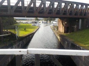
Crossing the Forth-Clyde CanalEnd of the line for the Forth-Clyde canal
I am afforded with some fantastic views back down the Clyde towards Greenock and the Cowal peninsular. I cannot see much on the opposite side of the bridge because of the metal barriers and strong sunshine. As I take photos at the crest of the bridge, I can feel significant movement under my feet due to the traffic – not for the faint hearted! On the far side a path leads down into Old Kilpatrick, the site of the ferry before the bridge was built. I am now in West Dunbartonshire. I am soon walking alongside the Forth-Clyde canal for a short distance before it reaches its lock terminus where the canal connects with the River Clyde.
A tight squeeze to get underneath this bridge
I have been walking along a NCN cycle way and the busy road some 100m has become my old friend, the A82. Although I can hear the main road, the cycle way hugs the path of the railway. I am soon on the outskirts of Dumbarton and walking past large warehouses holding Chivas Regal whisky. Shortly after the warehouses I see a green lane heading back towards the river, I follow it and pass under the railway track by means of a very low bridge, so low in fact I am bent double to get underneath it! I meet a couple shortly after who have just visited the Castle which sits atop Dumbarton Rock -a volcanic basaltic plug. I walk up to the entrance but see that its £4.50 to get in. I decline, as I have already had a great view for free from atop the bridge. I head past the football ground and into Dumbarton and my car parked near the station.
I had never imaged I would have got so far north of the Erskine Bridge by Christmas, but I am making good progress and hopefully will be able to push on west and get stuck into those dreaded sea lochs.
NB: I also publish all my Scottish Blog entries on the excellent Scottish Hills website, I use the same narrative, but larger photos and a few extra ones. They can be found here:
I wake up this morning to a World shrouded in fog! From my room on the waterfront at Greenock I can barely see the railings let alone across the River Clyde to Helensburgh. Today I am leaving my car at the hotel and getting the bus to Largs. I think I know the way to the bus station but have to ask twice, as I end up cutting it short to catch the 8:45. I make it with a few minutes to spare. As we pass through Gourock and Wemyss Bay I can see that the sun is trying see through the rapidly disappearing fog. Miraculously disappearing altogether when I get off the bus in Largs. The weather is just like yesterday, totally blue skies and a gentle breeze.
Nardini’s Art Deco Cafe LargsLooking south over Routenburn Golf CourseLooking across to Bute and Rothesay
As I prepare to start walking I had made decision to visit the renowned Art Deco establishment of Nardinni’s, the famed Italian Cafe and ice-cream maker. I order a double scoop of Rum&Raisin, its delicious! Close to the edge of town I decide that I will take the slightly higher route as there is 3.5 miles of road walking, without verges or footpaths on the busy A78. As I climb above Routenburn Golf Club I am rewarded with fantastic views across the Firth of Clyde. I can look south back to yesterdays walk past Hunterston, across to Great Cumbrae Island, the high hills of Arran which had now shed their early morning cloud and across to Bute the almost continuous procession of ferries toing-and-froing to Rothesay and back. The lane I am on is very quiet and it is a real pleasure to walk here. I realise that it is quite chilly out of the sun, so when I get into some extended tree cover I am forced to put my fleece back on. The lane descends to Meigle and I rejoin the A78.
From this point I have a footpath alongside the main road. However, the ACP disappears back up a side road, but I stay on the main road with it’s footpath hugging the shoreline. The road is very busy with Sunday traffic. I enter Skelmorlie and finally say goodbye to both the re-emerged Ayrshire Coastal Path (ACP) and North Ayrshire. The ACP on the whole has been a good friend for the last 100 miles. It only seems like yesterday since I picked it up in Glenapp. As I enter Wemyss Bay, I also enter the local administrative district of Inverclyde.
Preparing to set out for Rothesay
I pass the ferry terminal with the CalMac boat “Bute” about to set sail for Rothesay. Close to the ferry terminal is the charming rail station of Wemyss Bay and the terminus for this particular line to Glasgow.
Wemyss Bay Ferry / Rail station
I continue along the ever busy A78 towards Inverkip, but turn left at Kip Marina to enter the Ardgowan Estate which proclaims it welcomes walkers. I see the first of two signs indicating the Clyde Coastal Path. The Clyde Coastal Path(CCP) was another path derived by the local rotary club, but has yet, still requires a substantial amount of signage to be put in place. The walk around the Ardgowan Estate was a very popular walk along the shoreline, to emerge back on the A78 at picnic site.
The Cloch LighthouseHeading east towards Greenock along the River Clyde
I walk along the A78 further and come to the Cloch Lighthouse, which is a late 18th century lighthouse surprisingly not built by one of the Stevensons! The lighthouse is still in use today. I am heading further along the A78 towards McInorys Point from where the almost constant ferries shuttle back and forth between Hunters Quay (nr Dunoon). I am now walking along a promenade which is very busy with other walkers enjoying this autumnal sunshine. I arrive at the Gourock ferry terminal, but can see little activity there. Here I miss a sign for the cycle way (no.73) and head down the main street until I see a footbridge which takes me over he railway to rejoin the cycle way. The vista out towards the Firth of Clyde is complex, but I feel I can now recognise the towns and lochs I will be walking along in the coming months.
I am starting to feel the fatigue begin setting in as I reach the outskirts of Greenock, as with Gourock, Greenock is a very long strung out town. I have just passed over the recently built Battery Park which is full of people enjoying the sun on this Sunday afternoon. I continue down a further promenade, called he Esplanade before diverting around the Clydeport freight terminal. I finish at the old Custom House where my hotel is.
Another thoroughly enjoyable day walking amidst some beautiful and stunning scenery.
NB: I also publish all my Scottish Blog entries on the excellent Scottish Hills website, I use the same narrative, but larger photos and a few extra ones. They can be found here:
I’m back in Scotland for 3 days finishing the Ayrshire Coast, walking along the River Clyde and the milestone of this trip – crossing the Erskine Bridge. But first things first. I could see a three-day weather window that I thought would be too good to be missed. So I booked a two night stay at the Waterfront Apartments in Greenock and at £29/night I mustn’t grumble.
I drove to Largs and found a free place to park on the seafront. I then walked the short distance to the train station and caught the 8:53 train to Saltcoats. The morning had a chilly autumnal feel to it, with fog and mist shrouding the islands offshore and a very heavy dew soaking the grass.
The Town Hall at Saltcoats
Today I was mainly following the Ayrshire Coastal Path which clung to the shore resolutely virtually all the way back to Largs. I’d been to Ardrossan before, some years back to catch a ferry out to Arran to climb the Corbetts (hills between 2500 – 3000ft). I walked around the small beach between Saltcoats and Ardrossan with the tide just beginning to flow. As I passed Ardrossan harbour a Calmac ferry was just setting off to Brodick on Arran.
The next 3.5 miles was along the beach or on the small path that ran alongside it. The walking was very easy on firm sand and the beach was quite busy with the usual crowd of dog-walkers and joggers. The sun certainly brought the happy faces out. I passed through West Kilbride, although I saw little, as most of the town is set back from the shore.
Portencross CastleHunterston Nuclear Power Station
I eventually rounded Farland Head came upon the ruins of the 13th century Portencross Castle. The ruin looked to be in reasonable condition and offers free entry, although had closed the previous week for the Winter Season. I could now see Little (wee) Cumbrae Island as well as Millport on Great Cumbrae Island. I stopped and chatted to a dog-walker shortly after passing Portencross and chatted about dogs, as I normally do! I rounded a large crag to be faced with my fourth Nuclear Power Station on my coastal walks. The good news is that the ACP goes right past Hunterston A & B sites, albeit protected by multiple security fences. I pass down a quiet access road which takes me to the A78. The footpath then runs alongside the main road and is wide. Just as well really, as some nutter driving an Aston Martin, thought he should put his foot down, he must have gone past me at 100mph+. I also passed the other impressive industrial giant at Hunterston, the huge iron ore terminal with its massive conveyor belt system running high over the road and down to the Hunterston Clydeport docks.
Looking north up the Firth of Clyde at FairlieLooking across the iron ore terminal to the mountains on ArranThe Pencil monument at Largs
I enter Fairlie, which did not have much to offer, other than sending me down a dead-end road, which was partly down to my own fault. I was now approaching Largs and the sun was out and very warm. The views were abolutely tremendous, including those of Arran, now with all its tops clear of cloud. I passed around a large Marina with a fantastic display of Anchors, I really did not know how types of anchors there could be, but small info boards gave very interesting info. I entered Largs and passed close by The Pencil, a commemorative monument, built in 1912 to recognise the Victory of 1263 when the Scots defeated King Haco of Norway when his 160 ships got caught in a storm.
Because I was going to finish early, I had decided that I would take in a football game. I was hoping to make the Greenock Morton v Raith game; that’s until, I got caught up in the re-surfacing works on the A78 just outside of Larg. They were running a Convoy System…..and running it badly! Thus by the time I arrived at my accommodation it was almost half-time. Still the weather and views of this part of the coast made it all worth while.
NB: I also publish all my Scottish Blog entries on the excellent Scottish Hills website, I use the same narrative, but larger photos and a few extra ones. They can be found here: