51. Perranporth to Newquay

walk511
Looking back at Perranporth

The second day of my late Spring trip to North Cornwall. I get the early morning bus to Perranporth from Newquay. It is a beautiful sunny day with little wind as I stride out over Perrin Beach and the long stretch of Penhale Sands which has just been “combed” which seems to be quite common on Cornwall’s beaches. One purpose of this practice could be to bury the detritus from the previous days use.

walk512
Radio antenna at Penhale Point
walk513
The Gannel estuary
walk514
Wooden bridge over The Gannel
walk515
Fistral Beach, Newquay

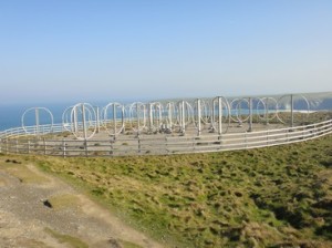
The dune system is quite high here with a good covering of grass. I join the jogging fraternity on their early morning exercise, perhaps not in speed but in direction. I descend back down to the beach as I go over an headland restricted by the tide. The next mile or so is pure beach walking. Eventually I climb up and over the next headland and round the MOD Penhale camp. I pass around a fascinating array of circles which look something to do with radar or radio antennas. I drop down into another secluded beach, Holwell Beach. The crowds are just arriving as I pass through the dune system and onto my next headland. Before I know I am descending to another smaller beach, which has a small group of bathers, facing into the surf as it rolls onto the beach. As I pass around Porth Joke, I move around a small headland Newquay comes into view, although I still have a way go yet. I must also cross the River Gannel. I descend down to Crantock Beach and join the many people who have set up their camp for the day on the beach. I am looking for the Fern Pit bridge which will take me across to Pentire, the western bit of Newquay. I do not see the bridge at Fern Pit because it appears it is only erected in tye tourist high season. I carry on further upstream following the Gannel. The tide is well out as I approach the foot bridge, which is exposed at low tide, at Penpol Creek. Between me and the bridge is a small channel, so it is a case of boots and socks off and paddle through. I put my boots back on and cross the wooden duckboards that form the bridge and make my way through Pentire towards Fistral Beach. I follow the SWCP into Newquay, which is heaving with tourists and surfers alike. I head along the main road towards Tolcarne Beach, where my hotel was the previous night. The walk has taken a very short 3.5hrs.

Distance today = 12.5 miles
Total distance =   743.5 miles


50. Perranporth to Portreath

walk502
Bat Castle above Hanover Cove
walk503
Looking towards St. Agnes

An early start for my 2 day trip to North Cornwall. I park at the football ground and walk around to where I think the bus stop is. I have a 40 minute wait for the bus, the sun is out but there is a distinct spring chill this morning. I see my bus coming, it disappears behind some houses and to my horror does not appear down the street I am waiting!! I check the bus stop sign I have been waiting under, which seems ok. They must have changed it. I decide not to wait for the next bus, but to reverse my walk direction i.e. I will walk to Portreath.

walk504
Mine workings above St. Agnes
walk505
Wheal Coates

I climb the steep road up and out of Perranporth, still seething after missing my bus. Almost immediately after gaining the cliff top I encounter industrial mine workings, which will be a familiar sight all the way to Portreath. Above Hanover Cove, I pass a number of old mineshafts. Some the shafts are capped with a conical iron mesh structure, locally called ” Bat Castles” probably die to the fact that bats still nest within the shafts. I drop down into Trevellas Porth and see more mine chimneys at the Blue Hills Tinstreams. The path descends to the outskirts of St. Agnes.

walk506
Porthtowan
walk507
Portreath

As I climb up the steep miners path out of St. Agnes I notice a deep worked quarry with open mine galleries facing into the open mine. After rounding St. Agnes Head the path contours well into the steep hillside and gently descends to more mine workings. I pass the tin mine Wheal Coates, which outer structure is well-preserved. Shortly after I descend into the small village of Porthtowan, where I am able to walk along its beach, as the tide is out. I contour along the cliff top passing around a MOD airfield, with its distinctive Golf Ball Radar on show. Soon after passing the airfield I begin my descent into Portreath. I have over an hour to wait for the next bus, so with the sun beating down, I head into the Waterfront Inn, where a few pints of Shandies help quell my thirst. The short 12.5 miles has taken me a leisurely 3.75 hrs.

Distance today = 12.5 miles
Total distance =   731 miles