198. Lochailort to Mallaig

I was not really looking forward to this walk, as heavy rain all day was forecast, plus I would be doing more than half of the walk along the A830.

I caught the 7:10 #500 Shiel Buses service down the A830. The bus met up with the #502 service from Acharacle, which I had caught yesterday. It was even darker this particular morning, with heavy rain clouds threatening to discharge their load at any minute. I set off down the road with hi-vis jacket and strobes, lit up like a christmas tree! On my drive up yesterday I could see that apart from a 2km section, there would be a very good  roadside  verge to walk along – and so it turned out to be.

The poor light, strong winds and showery outbursts caused me to keep my head down and keep on the move. I passed over and under the railway line a number of times. I did not expect to see any trains, as the derailment last week  due to a landslide  at Loch Eilt further down the track was not repaired yet, or so I thought. I was therefore surprised later in the day to see trains travelling up and down the line.

My first notable location was the Loch nam Uamh railway viaduct, the central pillar of which contains a horse and cart that fallen backwards in the cavity during construction in 1899. A little further down the road I came across The Princes Cairn, the traditional spot, Bonnie Prince Charlie left Scotland for good in 1746, bound for France.

Up till this point the walking had been easy, with a large flat grassy verge to walk along when traffic approached. However, for about a mile, the verge disappeared leaving me to keep a careful eye open for traffic, which mercifully was very light. I passed Beasdale Station, situated in the middle of nowhere and continued down the road half a mile, where a proper footpath appeared. However, I would not be making use of this footpath, as I turned off the main road and followed the old drovers  road to Arisaig. The old drovers road was a joy to walk along. When I reached Arisaig I popped into the local shop which sold warm pasties and coffee, which I consumed with delight (the chippy in Mallaig was closed the previous evening!).

Loch nan Uamh viaduct – the large cenral pillar contains an entombed horse and cart
The Prince’s Cairn
A deserted Beasdale station
Drovers track into Arisaig

I stayed on the B8008 for the next six  or seven miles as it wove its way through the Back of Keppoch area and other small shoreline settlements. On a normal clear day I would have been rewarded with views across to Rum and Skye, but not today. Instead I could still make out the distinctive shape of Eigg, which now appeared behind my left shoulder, progress indeed!

The B8008 did eventually join up with the A830 at Morar close to the bridge over the River Morar. I opted to take the small loop through the village. A smaller bridge carries this old road also across the River Morar which was in full spate as Loch Morar disgorged huge volumes of water through the narrow gap. I soon joined up with the main road again, which continued for a further 2 miles into Mallaig. By the time I reached Mallaig, the heavy rain which was forecast was throwing itself down backed by gusty winds.

Back of Keppoch beach
Deserted boat house and toilets Traigh Beach
On the bridge over the River Morar, above waterfalls
At last – only a month late!

My attention now turned to my next walk, which would be into Knoydart and at another time.

NB: I also publish all my Scottish Blog entries on the excellent Scottish Hills website, I use the same narrative, but larger photos and a few extra ones. They can be found here:

http://www.scottishhills.com/html/modules.php?name=Forums&file=viewtopic&t=23999

Distance today = 19 miles
Total distance = 3,519 miles


197. Lochailort to Acharacle

I struggled to get these two walking days in before the end of January due to bad weather in actually driving to the area; throw into the mix my 65th birthday which left me doing the walks with a couple of days left in January. So walking-wise I really had to take what the weather had to offer, although with both days predominantly road walking I was not too concerned if it rained a bit!

I drove up to Scotland on sunday afternoon with the weather getting progressively worse the further north I got. I needed to catch the Corran ferry to enable me to catch a 7:10 bus from Acharacle the following morning. I spent a very stormy night in the back of my car parked at the old road loop below the Corbett Garbh Bheinn. By the morning the storm had abated and moved off towards the east.

I was governed in which direction I could walk with the timings of the local bus service. Most of the buses on Ardgour operate a single bus service Mon- Sat to Fort William; where the drivers work at the garage until 15:00 before returning whence they came – basically  taking the kids to school and bringing them home again.

It was still dark when I got off the bus at Lochailort. I donned my hi-vis vest with matching red/white strobe lights as I set off down the road back to Acharacle. The A861 was very quiet with the odd infrequent car passing me. The road hugged the shore line of Loch Ailort for most of the first four miles. I could easy make out the tops of the Corbetts An Stac  and Rois-Bheinn which I had climbed from this road back in June 2008. As Loch Ailort opened out I had excellent views across to the Isle of Eigg and Rum, with the peak An Sgurr on Eigg prominent.

Early morning on the A861 looking back up Loch Ailort
The Corbett An Stac from the A861 near Roshven

When I reached the small settlement of Glenuig the road headed south up and over a  bealach before descending down to Loch Moidart. Moidart was in fact the area I was walking through today and would be my final district on the Ardgour peninsular. This area is a complex area of small islands and peninsulas which make it very difficult, on the ground, to tell what is mainland and what isn’t. I was now heading east along the shore of Loch Moidart; the route ahead was marked by the snow-capped summit of Beinn Resipole. I passed the rather inconspicuous cairn dedicated to the Seven Men of Moidart – supporters of Bonnie Prince Charlie. In fact the Prince stayed at the nearby Kinlochmoidart House (the old one which was burnt down in 1746) while awaiting support before raising his standard at Glenfinnan.

Glenuig Community Shop
Looking north to Loch Ailort at Glenuig

After crossing the Bailey bridge across the River Moidart I reached Ardmorlich. The next section of my walk would be along the southern shore of Loch Moidart, along what is called the Silver Walk.. The Silver Walk is so-called after a hoard of silver coins were found during the paths construction in the late 19th century. Most of the maps do not have the path continuing from Ardmorlich, but I had read of a path that kept close to the shore all the way along the southern shore. Signage was very poor, in fact there are just two signs, one at the start and the other at the end. However, the whole walk is actually a delight, which although wet and muddy at the start keeps you very busy as it twists and turns. Certainly the best part of the walk is at its western side, where you find it very difficult to believe that a footpath could exist along the very steep slopes. Eventually, after passing around Sgiorbaid Dubh, you enter the estuary into which the River Shiel enters Loch Moidart.

Looking east down Loch Moidart with Beinn Resipole in the distance
Seven men of Moidart cairn
Looking west down Loch Moidart across the Bailey Bridge from the old packhorse bridge over the River Moidart
Looking west down Loch Moidart from the Silver Walk
Looking east back up Loch Moidart
Passing through a ravine on the Silver Walk
On the Silver Walk
On the Silver Walk
On the Silver Walk

From this point I got my first sight of the ruins of Caistel Tioram situated on its own tiny tidal island. The tide was out so I was able to walk across the small sandy bar out to the ruins. At first glance the castle looks quite small, however,  when I entered the castle through a small grill, which I suspect is normally locked, the castle showed itself to contain a good number of features.

I joined up with the public road and continued south. The road took me along the banks of the swollen River Shiel has it made its way out of Loch Shiel into the sea. I crossed over the River Shiel just as the road entered Acharacle where my car was parked.

Eilean and Casteal Tioram
Casteal Tioram
Inside Casteal Tioram
Along the banks of the swollen River Shiel

I had booked myself into the Fisherman’s Mission Bunkhouse in Mallaig, quite basic but warm , cheap and friendly at £25 per night.

NB: I also publish all my Scottish Blog entries on the excellent Scottish Hills website, I use the same narrative, but larger photos and a few extra ones. They can be found here:

http://www.scottishhills.com/html/modules.php?name=Forums&file=viewtopic&t=23997

Distance today = 22 miles
Total distance = 3,500 miles


196. Acharacle to Achateny

After yesterdays walk I drove to and parked at the same car park as I stayed last night. I had quite an uncomfortable night’s sleep as I had forgotten to pack my thermarest-type ground mat.

In the morning I drove a few miles to the end of the public road to Achateny. From there I caught the #506 to Acharacle. There was only the bus driver and myself on board for the first three miles. However, the day was to have a very sad start. As we neared Glenborrodale I heard the driver shout and then there was a thump from the front of the bus. We had hit a deer. The driver reversed back up the road and we both got out. The deer was lying in the road, it was just a fawn. It was still moving, although its twitching was probably just nerves. A couple of cars stopped to ask what the problem was. The driver said he would speak to a keeper at the next stop, who would be dropping his children off to catch the bus to school. Myself and the driver carried the young deer and placed it on the grass verge. It had stopped moving by now. The driver was quite upset about it and I know how he felt. I suppose there are scores of deer strikes throughout Scotland on a daily basis – but it was still sad.

Just before the school in Acharacle I got off the bus and began walking  along the A861. I was not on it long before I turned left down the B8044 heading towards Kentra Moss. After a kilometre I turned left again down a minor road  towards Arivegaig where the public road ended. Crossing the Allt Beithe by means of a bridge I continued along an Estate track heading towards Gorteneorn. At Gorteneorn the track disappeared into the forest and carried onto Gortenfern , where I crossed another bridge. The track next climbed up onto high moorland, becoming rougher as it reached about 180m. As the vehicle track veered off to the NE I continued along a faint footpath which clung to the steep hillside. I had to be careful as there where numerous frozen puddles and ice pools covering the path and ground. However, the frozen ground made for fast walking as I soon emerged overlooking the northern shores of Ardnamurchan. As with yesterday I had splendid views across to Eigg, Rum and Skye. I could also see across to Knoydart with the snow-capped Ladhar Bheinn prominent.
The footpath descended steeply down towards a vehicle track which continued onto the small settlement of Ockle. Ockle marked the start of the public road. I had made very swift progress again with the aid of a strong wind at my back. I continued along the road passing by the small hamlets of Kilmory and Branault before joining up with the Achateny road and thence back to the car.

Tuesday morning rush hour in Acharacle
Looking over Kentra Bay with the Rois-Bheinn group of hills right
The route ahead over Liath Dhoire
Looking north to Eigg, Rum and Skye
Narrow path above the Allt Eilagadale
Looking down north towards Eigg
Heading towards Ockle
Looking down on Swordle Bay, site of a Viking Boat Burial

NB: I also publish all my Scottish Blog entries on the excellent Scottish Hills website, I use the same narrative, but larger photos and a few extra ones. They can be found here:

http://www.scottishhills.com/html/modules.php?name=Forums&file=viewtopic&t=23980

Distance today = 14 miles
Total distance = 3,478 miles


195. Achateny to Achosnich

It had been late October since my last visit to Scotland due to a number of frustrating reasons. I had even opened up a “second front” continuing south from Berwick-Upon-Tweed down the Northumbrian coast. This trip would hopefully see off almost all of the Ardnamurchan section on the Ardgour peninsula. Although I did not achieve my 2017 goal of getting to Mallaig by Christmas, I have now set myself new goal for 2018 by reaching  Cape Wrath by December. This will be a significant milestone hopefully  having completed the whole of the West coast of Scotland, including Skye.

I had travelled up the day before in order to get a reasonable nights sleep in the back of the car. I managed to catch the penultimate Corran ferry on Sunday evening and drove on towards Kilchoan. I parked in a small car park 7 miles from Kilchoan. That night I got out of the car to have a look at the night sky. Wow! It was probably one of the best views I have ever had of the Milky Way. I don’t think I have ever seen such a night sky with so many stars! Although it was a freezing night (-6deg coming over Rannoch Moor) it was not unduly cold in the back of the car.

In the morning I set off very early to drive to Achosnich to park the car. I then walked back down the road to Kilchoan. This meant re-tracing part of my previous route that I did last October. I waited at the Spar shop in Kilchoan to catch the 7:50 bus #506 for the short journey to the Achateny road end.

It was light when I got off the bus and started walking towards Achateny. The view north was quite amazing with the snow-capped peaks of Rum and the Cuillins dominanting and drawing the eye for the majority of this walk. In addition , although clear of snow, was Eigg and Muck which were the closest islands to the north. Although the sun was out, it was a bitterly cold day, made worse by a strong easterly wind, which fortunately, was at my back for most of the day. I passed by the small hamlet of Achateny and continued along the public road to another small settlement at Fascadale. Here the public road ended and I picked up a rough track and continued westwards. Although the ground was frozen in most places, I got the impression that this area would be very wet to walk over in warmer temperatures.

Looking across to the snow-capped peaks of Rum with Eigg on the right
Looking into the far distance at the snow-capped peaks of the Cuillins on Skye, Eigg is left
Early morning sunlight on the Rum peaks
Looking across to Eigg from Fascadale

The track, what there was of it, disappeared after a couple of miles heading SE down Glen Drian. I picked up feint deer tracks and headed WSW over boggy ground. I soon spotted Sanna in the distance.  After I passed the old ruined  settlement of Plocaig, I managed to cross a large burn that was too wide to jump. I then had to negotiate quite a large bog, which meant weaving my way in and out to try to get myself to the road. The public road ends at Sanna and in summer it is quite a popular place because of the white beaches. Today the place was quite deserted. I spent some time studying an Info board describing the unique  geology of the area in the shape of the volcanic ring dykes and  calderas that exist close by. I must admit I had forgotten the term Eucrite (a type of slow-cooled Gabbro) which form most of the extrusions in the area.

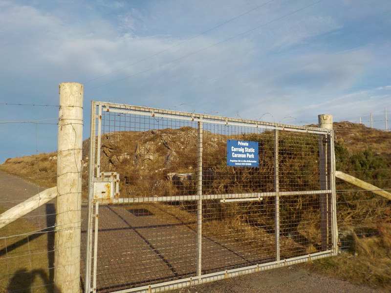
I picked up a reasonable track which gradually disappeared as I made my way to the next hamlet of Portuairk. I walked through Portuairk heading for the last house of the public road, which had a footpath leading up and behind the houses. Climbing above Portuairk I had a beautiful back towards Sanna and with a backdrop of the Small Isles of Eigg, Muck and Rum and Canna. I was now heading towards  the B8007 which would take me onto Ardnamurchan Point. However, I first had to get around a caravan sites which had a deer fence all the way around it, topped with barbed wire and a locked entrance gate, also with a coil of barbed wire along its top. I chose to walk around the site, which resembled a Stalag Luft POW camp. On reaching the road I now had an out and back over 4 miles to the lighthouse.

The route ahead westwards across trackless terrain
Approaching Sanna with the Isle of Coll in the far distance
The ruined settlement of Plocaig
A deserted Sanna
White sandy beaches at Sanna, the Isle of Muck is centre left
Approaching Portuiark
Looking back at Portuiark and Sanna

Ardnamurchan Point is popularly known as the most western point of mainland Britain. However, the actual location for the most westerly point on mainland Britain is Corrachadh Mòr, lying a mile to the south of Ardnamurchan Point. I visited the lighthouse, which has a visitor centre; but it was closed and there was not a soul in sight. I retraced my steps along the B8007 and continued onto Achosnich.

NB: I also publish all my Scottish Blog entries on the excellent Scottish Hills website, I use the same narrative, but larger photos and a few extra ones. They can be found here:

http://www.scottishhills.com/html/modules.php?name=Forums&file=viewtopic&t=23978

Stalag Luft IV caravan park
Approaching Ardnamurchan Point
The granite lighthouse at Ardnamurchan Point
Jacob sheep at Grigadale

Distance today = 18 miles
Total distance = 3,464 miles