Today was a simple day trip to Cumbria utilising a small weather window and allowing me to fill the Cumbrian gap between Allonby and Gretna. There were no trains in this neck of the woods, so it was the use of a couple of buses that would get me from Abbeytown (where I had parked) to Allonby, where I would start. But first it was a very early bus #400 from Abbeytown to Silloth, then the #60 bus to Allonby.
Early morning light looking back at Allonby and the snow covered Cumbrian Fells
It was bitterly cold as I waited for my buses, but today I would have the slight breeze at my back. There had been another overnight severe frost, but even though I started walking under an overcast sky I had superb views across the Solway to Dumfries and Galloway and in particular, the hill of Criffle. I head straight for the beach and am soon walking over hard firm sand. The tide, although beginning to flow, still allows me a generous portion of the beach to walk along. I stay on the beach all the way to Silloth.
One of the things I do, and think other coastal walkers should do as well, is to improve my identification and knowledge of seabirds. I am no expert, but always try to identify birds, particularly those I see along the beach. Today, I pass a number of flocks of Oystercatchers, perhaps the most common seabird I see on my walks along the coastline. It is an easy bird to recognise, but is also a very noisy one. I see a large flock of small grey waders with white bellies, I think they are Dunlin, although they could be Knot. They take off and I am treated to quite a Murmuration from this large flock. I also pass a couple of Turnstone, which I also manage to recognise.
Unloading cargo at Silloth dockSilloth
In no time I reach the small town of Silloth. I walk around the small docks, where a container seems to be disgorging its cargo of grain. Silloth seems a nice little town, with its small collection of shops and cobbled streets. I head past the lifeboat station and continue a walking north along the promenade towards the village of Skinburness. I pass the rebuilt East Cote lighthouse, a mobile structure built on rails to facilitate entry to the Port of Silloth channel. I read another info board which tells how the Roman influence much further south down the Cumbrian coast, from the end of Hadrians Wall, with a series of forts and towers.
Grune Point looking across Moricombe baySea Dyke at SkinburnessTidal River Waver near Abbeytown
I am now heading out towards a small tongue of land that juts out into the Solway Firth, the tip of this promontory is called Grune Point. I stand here awhile and look across to the Scottish coastline, where I can now make out individual houses. The sun has now come out , with lovely blue skies visible across the Solway. I head around Grune Point and begin walking back towards Skinburness, this time around the shores of Moricambe Bay, which I must now walk around. Moricambe Bay is much smaller than the similarly sounding Morecambe Bay and is feed by the two rivers of Waver and Wampool. I keep to the sea dyke round, preferring that to the Cumbrian Coast path across the Marsh, which seems not well-marked. I continue along roads towards Brownrigg where I join the River Waver and walk along its tidal banks. The going is very heavy as I reach the outskirts of Abbeytown as I cross recently ploughed fields. I take 5.5 hours to finish this walk.
Distance today = 19 miles
Total distance = 2464 miles
Its getting more difficult to find a ‘weather-window’ to allow me not only to have a reasonably nice walk (weatherwise) but also to get a good a mileage in. So as the first real storm of Winter (Storm Angus) batters the south coast of England, I head for the more quieter coast of West Cumbria to continue my walk.
I arrive in the small village of Allonby early morning after a severe frost. It’s about -3 deg and it’s really cold. There is also a stiff breeze blowing from the north, making it feel like -10!
To get to my start point in Whitehaven I must first get the 14min bus journey using the #60 to Maryport, then its a 30min train ride to Whitehaven. By the time the bus arrives my feet and toes are freezing.
I arrive in Whitehaven and my feet have just about thawed out. I pop into the local Tesco, which is adjacent to the station for a sandwich and biscuits. Today the whole route follows the newly opened England Coast Path. I hope I will not need to consult my maps too frequently. I must say however, the route depicted on my recently printed off OS map differs in many places to the actual signage on the ground; which seems to follow predominantly, NCN cycleway #72. I soon end up following the route shown on the map, which clings well to the coast.
Tramway leading to Parton
I head north along the old tramway between Parton and Whitehaven. I am going at quite a pace because I am walking directly into a stiff freezing breeze coming down from the north. I am rewarded with fantastic views across the Solway to the snow-clad hills of Dumfries and Galloway, in particular Criffle, which dominates the view north. I see little of the Cumbrian Fells, which are hidden for most of the walk, although even they have a fair dumping of snow on them. I am walking alongside the railway, which I will continue to do so for most of today’s walk.
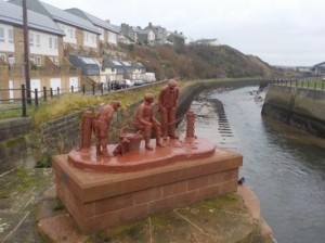
Crucifix above WorkingtonHarbour workers shelter c 1800 at WorkingtonLooking north across the Solway to Criffle
I reach the small village of Parton and pass under the railway, something I will do many times as the path continuously criss-crosses the line. I climb up above Parton onto Lowca Fell. I get an even better view now across the Solway and the Mull of Galloway now comes into view. The path then skirts around the small wind farm at Lowca before dropping slowly down a green lane into Harrington. I pass under the railway and walk around the harbour, which at low tide looks empty. I continue alongside the railway to the outskirts of Workington. The path has diverted slightly inland to bypass a huge derelict tract of land once taken by some large industrial works. Part of this site has been landscaped and I climb up onto a small hill, once slag heaps, overlooking Workington. The grey overcast skies do not make the place look any better. On this hill I pass, surprisingly a large crucifix, made out of wood and with a metallic Jesus Christ figure. It looks ok and I later find out it was built and erected by a local man whose wife had recently died. He applied for retrospective planning permission in 2015, which was granted. The effigy, gives the hill a very Calvaresque appearance.
Memorial plaque to PC Bill Barkley on Northside Bridge Workington
I drop down to the banks of the River Derwent and continue to the first bridging point. I pass around the Rugby and football grounds and stand awhile on the rebuilt (2012) Northside Bridge which was swept away in the 2009 floods, which also claimed the life of PC Bill Barker, who was on duty on the bridge at the time. A plaque to Bill is set in on the bridge walkway. I had visited this bridge of a few occasions (while watching my local team play Workington) previously and I remember visiting not long after the floods, when I could see remnants and debris of the previous bridge below in the Derwent.
I move on and pass behind an industrial area and across a Traveller encampment alongside the road. The whole area, is covered in litter, fly-tipping and dogs running free. I move on and pass under the railway to gain the shore.
I next come across a local dog walker out exercising his 5 Lakeland terrier pups, they are a bundle of joy, full of energy, running here and there and very affectionate. We talk awhile, until I realise that time is pressing and continue onto Flimby. I also realise I have again followed the signs pointing me back onto the road, when I could have easily stayed on the shore.
Colin Telfer statue at MaryportLooking north along the promenade towards Allonby
I enter Maryport, as the rain fore-runner of Storm Angus begins to arrive. Its getting quite dark now and still only 13:30. I walk around harbour at Maryport, perhaps not giving it my full attention. I join the promenade which runs for over a mile north. I also say goodbye to the railway which skirts north-east inland towards Carlisle. Where the promenade ends at Maryport Golf Club, the signs point inland. I opt to get onto the beach and for the next 3 miles stay on the sand all the way into Allonby. The rain begins in earnest as I arrive back at my car. It is also quite dark, even though sunset is not for another hour yet. The drive home down the M6 is not very nice as the north feels the full force of the storm.
Distance today = 20.5 miles
Total distance = 2445 miles
It was back to Cumbria today for a forecasted sunny day – and so it turned out to be! I also knew I had four rivers to contend with. With the onset of Winter, the amount of daylight hours available for walking is diminishing rapidly, thus because today was going to be a long walk, I needed to start at the first available light. I was resuming my normal direction of travel today, as tide and train times did not dictate where I started.
I had found a free car park in Whitehaven, just a few minutes walk away from the train station and it was there that I arrived just before 6 in the morning. I was treated to a fantastic view of the night sky, as it had been a cold clear night and there was little light pollution. I caught the 6:31 train to Ravenglass. It was packed full of workers starting their early shift at the Sellafield plant. When the train reached Sellafield, virtually the whole train got off, leaving just a few passengers to continue their journey.
Crossing the River Mite at RavenglassCrossing the River Irt at Holme Bridge
I arrived in Ravenglass with good light, so need for the head torch this morning. I made my way to the railway bridge, where I had to cross the first of four rivers today. The River Mite, together with the River Irt confluence with the River Esk into a small tidal estuary. Having already forded the River Esk at my last visit, this mornings crossing of the River Mite would be much easier, even though I arrive at low tide, due to a pedestrian bridge that runs along the railway bridge. I cross over the Mite and proceed through the small hamlet of Saltcoats. I must now cross the River Irt. There is a small ford to do so, but I have read from other travellers that it is not a good proposition, so I must divert inland a short distance.
I eventually cross the Irt via Holme Bridge, a packhorse bridge from the early 18th century. A few fields later and I am passing through the small village of Drigg. I cross over the railway at Drigg station and continue to head toward the shoreline. I am now walking beside a large fence, with razor wire, this is a licensed nuclear site dealing with low-level waste, probably from the nearby facility at Sellafield. The road follows the perimeter fencing around the site before finally a taking a direct line to the shore.
The view ahead with Sellafield and St Bees Head visibleThe memorial plaque to the victims of the West Cumbrian shootings
I am now on the beach, with the tide out I can make way along firm sand which makes for excellent walking. Ahead I can see the Sellafield plant, St Bees Head and two Scottish hills that I saw on my last trip. I can also see The Isle of Man. I come back onto land as I pass by the small village of Seascale. I walk over to the a small, mock-turreted platform. A plaque on the side of the wall is to the Victims of the West Cumbrian shootings of 2010, in which a taxi driver Derek Bird murdered 12 innocent people and injured many others. The plaque is mounted below a cannon.
About to cross the River Calder at Sellafield, the River Ehen is upper leftRailway gate access intio the power station
I am now walking along NCN 72, which runs alongside the railway line towards Sellafield. Eventually, as I approach the power station I am confronted with my third river, The Calder. Fortunately, this river also has a viaduct for both trains and pedestrians. Confluencing at the same point is the River Ehen, which is a wider river and which I must also cross at some point. I am now walking along the huge perimeter fences of Sellafield nuclear power station. I take a few photos, not wanting to advertise myself in this ‘sensitive’ area. I make my to Sellafield train station, which I see has a bridge crossing the Ehen. On closer inspection, I see large fences , a railway to be crossed and apparently the footbridge across the Ehen is closed to the public. I must therefore make a short inland detour to cross the Ehen.
Crossing the River Ehen at Middlebank
I follow the perimeter fencing for a while, until it crosses the main road into the plant and heads towards an old rail route to Egregmont. I pass many others, all dog walkers. At Middlebank, I turn off the main cycle route and head towards a small footbridge that crosses the River Ehen. The bridge is a simple affair with a series single wooden planks strung out in a straight line suspended by wire ropes. I head across green pastures with a large herd of cows, they show little interest in me as I head along banks of the Ehen until the railway is met. I find small underpass which takes me back onto the beach.
I continue along the beach for the next 2 to 3 miles, passing close to Braystones on the way. With the incoming tide I am finding it more difficult to find good walking sand. By the time I reach Nethertown, I am walking on large cobbles. I decide now to transfer back to the small road which runs some 200m from the shore. I ascend the small cliff at Nethertown station and join the quiet road. I stay on the road nearly all the way to St Bees, before cutting down a small green lane to the railway and beach.
Start of the Coast to Coast Path – St BeesLooking back at St Bees from South Head and the route I have comeLooking towards North Head Lighthouse and in the distance the Scottish coast
I cross the beach at St Bees and come ashore to find the start indicator for Alfred Wainwrights Coast to Coast walk. I head off along the path which will now rise to much higher ground, that makes up St Bees Head. The walking is easy and although I have already done a fair few miles I get to the top of South Head without any problems. I am rewarded with some amazing views particularly to the southern shores of Dumfries and Galloway and even the tip of The Mull of Galloway many miles away. I can also confirm that the hills I had first espied back at near Bootle, were indeed Carinsmore of Fleet, Cairnharrow and Bengairn. I continue along the cliff top walking towards the lighthouse near North Head. The red sandstone cliff top walk is delightful and easy-going. As I round North Head I am rewarded with even better and more panoramic views up and down the Solway Firth. I can now see a great deal of the Scottish coast line, including the hill of Criffle, above the city of Dumfries. Whitehaven is also now in view, further along the dramatic cliff coastline. In the far distance I can see the foundry at Workington beclhing smoke. It is a truly magnificent vista.
Impressive new kissing gatesWhitehaven
I head towards the outskirts of a Whitehaven, passing through a series of quite new and stylish kissing-gates, an obvious pre-cursor to the coming England Coastal path, the signs for which I did see on the newly opened section towards Allonby. I passed by the sold coal mining sites of the town, now preserved as a museum and above the old Saltom mine, Britain’s first under-sea mine. Unfortunately, the paths about are strewn with dog mess, every which way you turn. Whitehaven, does have a lovely little harbour, although the marina seems to dominate its use.
I’m glad when I eventually reach my car. I have been walking for almost 8 hours continuously, and the legs are beginning to fade a bit. Still, worth all of that for the walk over St Bees, which must be saved for a clear day.
Distance today = 24 miles
Total distance = 2424.5 miles
Today I’m going to be walking north – south, the reverse of my normal direction. The reason for this, is that I must get over the River Esk, near Ravenglass. I could walk the 3 and a bit miles inland to the first bridging point or be a bit naughty and nip across the railway viaduct. Instead I decide to ford the river, but to do so I need to cross at low tide, or a couple of hours either side of it. Low tide unfortunately, is at 6:21 in the morning, so not only do I need to start my walk at Ravenglass, but I need to get a train from Millom to Ravenglass, that will put me within the low-tide window.
I park in Millom and get the 6:20 train, its full of shift workers making their way to Sellafield, further up the coast. Most of them are asleep, I can’t blame I’ve been on the go for some 3 hours already driving up here. It’s still dark as I arrive in Ravenglass, but I can see the faint glow of the daylight coming over the Fells. I make my way down the main road in Ravenglass and emerge on the shore. The tide is well out. I have about a 1.5km to walk to the Railway Viaduct over the River Esk, where I fill ford the river. But first, I need to make a minor detour on the way in order to visit the well-preserved Roman Bath House.
Roman bath House ruins – RavenglassCrossing point of the River Esk – heading for yellow flagNot that deep – but freezing!Looking back across the Esk
Although, the sun has not yet risen, it is still light enough to see where I am going. Unfortunately, my photos, of the Bath House are not good in the poor light. I approach the River Esk and have a 40 and a 5 metre wide channel to cross. I have arrived about 50 minutes after low tide and the river is not in spate. The height of low tide is 1.39 metre. I remove my walking boots and socks and change into a pair of plastic crocs. The water is absolutely freezing, but it barely comes up to my calves. The ground is firm and stony as I make it over both channels in about 3 minutes. The sting in the tail comes in the form of sticky gluey mud on the far bank which sucks my crocs off, requiring me to retrieve them from the mud and walk the last few yards barefoot. If I had been walking in the opposite direction, it would not have been so bad, because the water would have washed the mud away, as the bank I started from was gravel and sand. I cleaned the gooey mess with a towel I had also bought with me.
Jacob Sheep
I was now outside the Eskmeals Firing Range and a yellow flag was flying which meant the Eskmeals Dunes Nature Reserve was closed. The firing range was also off-limits as red flags were flying. So it was a case of keeping to the quiet road which took me back to the shoreline at the far end of the firing range. Towards the end of the firing range I passed a field with a small flock of very unusual sheep. Nearly all had four horns and were piebald(white with coloured spots), these were Jacob Sheep, a very old and rare breed.
Looking north with St Bees Head right and 3 land masses in the far distance in Scotland (although v.difficult to see)
I now had access to the beach and the view which greeted me was amazing. The sun was just about up, but it was the view north , which took my eye. I could see the buildings of Sellafield quite easily, but just to the left of St Bees Head I could see three raised land masses. (For a better view look at my main banner photo). This was my first sighting of Scotland from the English leg of my walk. I was unsure which of the hills in Dumfries and Galloway I was looking at but upon checking later I believe one of the hills was Cairnsmore of Fleet a hill of 711 metres, and some 55 miles away and which I had climbed in 2011. The other two hills could have possibly been Cairnharrow and Bengairn.
In the Hyton Marsh reserve
I now moved onto the shoreline where I remained for the majority of the walk. The tide was still out and I could easily pick my way along the beach, searching for a fine gravel and sand line which offered the best footing for walking. I entered the Hyton Marsh Reserve, which protected the environment of the Natterjack Toad. On my right and restricting my access to the beach a small river channel had developed. The Reserve contained a large and impressive wooden bridge which now allowed me to get back to the beach.
Looking towards the Lake District Fells at Tarn PointLooking back
My next section of coast led me in a straight line of some 5 miles, with nothing but boulder clay cliffs on my left, the sea on my right and the shingle beach heading in a straight line towards Barrow, which I could now make in the far distance. Near Silecroft, I met a lady who was walking in the opposite direction to me. We spoke and she said she was doing the Cumbrian Coastal Path, the signage was poor, yes very true! She said that she was late starting because the trains had stopped following a vehicle hitting one of the bridges further up the line! Hmm glad I started earlier after all!
Escape to Light sculpture at Haverigg
I passed the golf course, Wind farm and prison at Haverigg. After two hours of crunching on beach shingle I opted to walk through the dunes at Haverigg and began the slow turn east into the Duddon estuary. Eventually I entered the small village of Haverigg and was greeted by an impressive sculpture called Escape into Light by the sculptress Josefenia de Vasconcellos, at the time the world’s oldest living sculptor. This particular work she sculptured well into her 90’s. She died in Blackpool in 2005 aged 100 years.
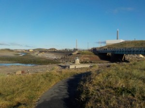
Hodbarrow Nature Reserve and lagoon with Black Combe in the background
I leave Haverigg behind and begin the long circular walk around the Hodbarrow nature Reserve, a huge lagoon built on what was the Hodbarrow Iron Ore Mine and Millom Ironworks. The huge seawall provides a massive enclosure for the lagoon and utilises slag and clinker as part of the huge defences. I head across grassland and emerge again at the Duddon estuary, walking along its shore back into Millom.
Distance today = 20 miles
Total distance = 2400.5 miles