263. Lochinver to Stoer

Two tough days of walking had made me rather apprehensive about completing a third day of even longer length, especially with high temperatures forecast. I had intended to walk all the way around the Stoer Peninsular but decided to leave this section of the walk to my next trip up north and so decided to terminate the walk at Stoer village.

There is a bus service that runs from Drumbeg, a small hamlet on a narrow road to Kylesku to Ullapool via Lochinver – the #809 service run by George Rapson. However, you must pay very close attention to the timetable, particularly around school holidays and where you want to be picked up. None of this vital information is mentioned on the Scotland Traveline site, which I actually got from the bus shelter in Lochinver the previous day. I had requested that I be picked up at Clashnessie, but as I was now cutting my walk short, this would mean an extra mile of road walking. Fortunately, as I drove very early through Stoer towards Clashnessie I saw the #809 bus parked up at the village hall, so I parked there and waited for the bis driver to appear. It would save him driving a few extra miles there and back to Clashnessie and save me a mile of road walking. The driver appeared at 7:00 and we set off towards Lochinver, picking a few passengers up on the way, including another backpacker who had a very compact bicycle folded up into the size of a briefcase!

At Lochinver I got off the bus and started walking out of the village, after half a mile I realised that I had left my walking stick at a park bench shortly after leaving the bus, I contemplated leaving the stick but decided to retrace my steps and pick it up…………..grrrrrrr!

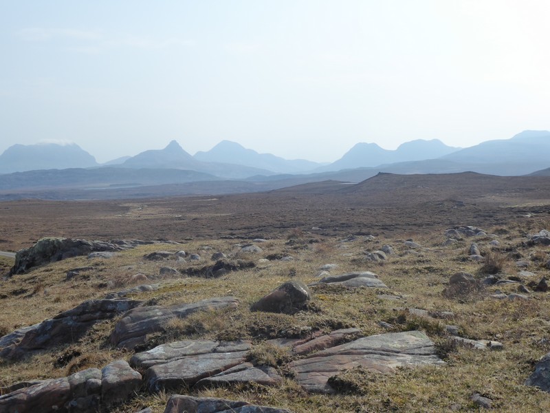
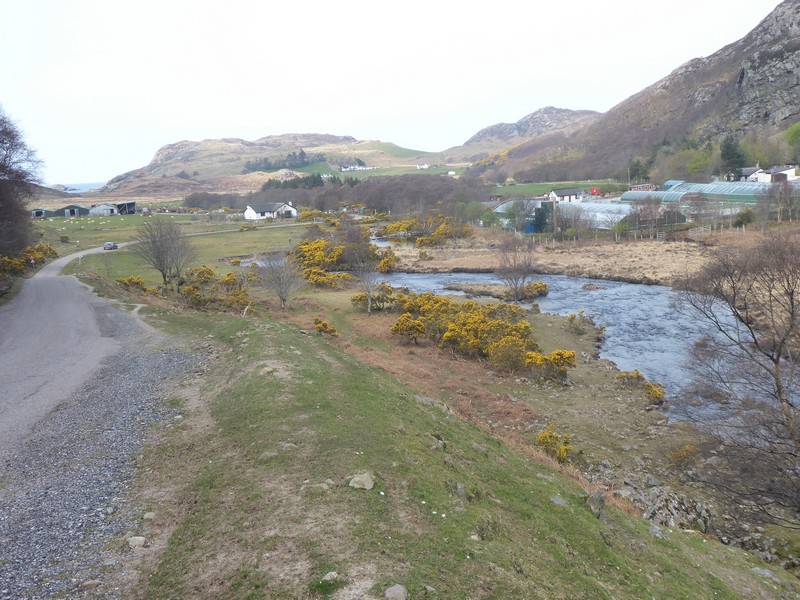
Take two and I set off again  walking out of the village. I was heading for the small hamlet of Baddidarach on the opposite side of the loch. Here I would pick up a footpath which would take me to Ardroe and thence the road out to Achmelvich. The footpath was well trodden and of excellent construction. With the sun at my back and a gentle breeze, it was lovely to be out walking in the North West of Scotland. Looking at the terrain either side of the footpath, it was not difficult to imagine that without a path, this type of terrain would be extremely challenging to get around. I arrived at the few houses that make up Ardroe and continued along a rough road, which lead onto a narrow tarmac road.

The well-known pie shop at Lochinver, unfortunately it was closed
Looking back at Lochinver with Canisp and Suilven in the background
On the path to Ardroe
Approaching Ardroe
A lone Shag which I had disturbed heading towards Loch Roe

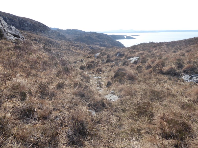
I soon arrived at the shoreline hamlet of Achmelvich, where a large-scale build of wooden chalets/pods/yurts was underway to add to the existing static caravans and youth hostel, it seemed a very popular place. I crossed over the small beautiful white sanded beach heading up a rough track and picked up the footpath that would take me back onto the road. The footpath was another well-trodden path and very enjoyable to walk along. I passed by a few isolated holiday homes at Alltan a’bradhan and up a small ravine where I emerged onto the B868. The road was busy with a steady stream of traffic, particularly motorbikes, completing I would imagine the NC 500. I stayed on the road through the village of Clachtoll and then onto Stoer village hall where I had parked my car.

Looking back at Achmelvich
On the footpath towards Clachtoll
This ravine would lead me onto the B868
Looking down on Clachtoll, Stoer is in the far distance
Looking back Clachtoll beach

NB: I also publish all my Scottish Blog entries on the excellent Scottish Hills website, I use the same narrative, but larger photos and a few extra ones. They can be found here:

http://www.scottishhills.com/html/modules.php?name=Forums&file=viewtopic&t=24512

Distance today =  10 miles
Total distance = 4,764 miles


262. Altandhu to Lochinver

Today would be more of the same as yesterday with both road and off-road walking.

As there is no direct bus service between Altandhu and Lochinver I had to catch two separate buses via Ullapool. I made an early start by first driving and parking in Lochinver and caught the 7:45 #809 Rapson bus service to Ullapool, where I had to wait about 90 minutes until my next bus. Fortunately, I did not have long to wait for The Tea Room to open where I could get a latte and scrambled egg on toast. At 10:00 I caught the same bus that I had caught yesterday, the #811 to Altandhu. I was the only passenger, so I managed to have another long conversation with Kenny, the accordion ‘star’ from the film Edie.

I got off the bus at Altandhu camp site and set off back up the road. I was going to walk across the whole of the Rubha Mor peninsula, but decided against it. Today the sun was out and the biting wind gone, so it was going to be a tough day walking in the heat. I continued walking across the Rubha Mor heading for Achnahaird. I came across a Rabbies minibus that had just disgorged its occupants to take a better look at the distinct and iconic Assynt mountains. I spoke to a Kiwi who was part of the group, who asked me how far I was walking today, I said Lochinver, but I don’t think he knew where that was.

Just before the turn-off at Badnagyle a car stopped with two ladies in it, they asked me If I knew where the car park for Stac Pollaidh was. I said they had passed the car park some 2 to 3 miles ago and pointed out Stac Pollaidh in the distance.

Isle Ristol, part of the Summer Isles
Hazy Assynt skyline
Cul Mor (l) and Stac Pollaidh (r)

After turning off the main Achiltibuie road, the amount of traffic diminished becoming a lot more quieter. The road climbed over the Aird na Coigich and dropped steeply down into Strath Polly. At Inverpolly just before I crossed over the River Polly I met a Dutch couple who were holidaying in the area. Just after the bridge I headed down an estate track that would take me towards Inverpolly Lodge and then a slow descent down to the shoreline and boathouse. Most of the Assynt coastline is riven with small inlets, coves and bays that make this coastline incredibly complex. I crossed over an old breached weir dam which emptied the small adjacent Lochan Sal. After crossing the dam I would be on a footpath for the next 2 to 3 km. I tried to stay on the footpath, but soon lost it. I tried using the contours of the small hummocks to follow or find the footpath, but it was not possible. Following my own route I finally picked up a track of sorts, but even that disappeared as I approached the stepping-stones across the Allt Gleann an-Strachain. The burn was very low and I easily crossed over and re-joined the narrow road. Over the next 3 km only a couple of cars passed me.

Approaching Inverpolly
Locals near Inverpolly Lodge
Dam and weir near Lochan Sal
Looking back towards Inverpolly
Stepping stones over the Allt Gleann an-Strachain

The road climbed again before dropping down again into Inverkirkaig, crossing over a bridge spanning the River Kirkaig, passing out of Ross & Cromarty and into the historical county of Sutherland. the car park at the bridge had a few cars in it, mainly for visitors to the nearby Falls of Kirkaig. There was also a coffee shop close-by where I topped up my water supply. I continued along the road into the late afternoon, catching the odd glimpse of Suilven, from the head-on position and managing to pick out 3 walkers on the summit!! After passing through the small settlement of Strathan I arrived back at my car that I had left 11 hours earlier. A tough days walk.

Crossing over the River Kirkaig
Goodbye (for now) Ross & Cromarty and hello Sutherland
The beach at Inverkirkaig
Suilven popping out from the Glencanisp Forest
Zoomed shot of Suilven with walkers on the summit

NB: I also publish all my Scottish Blog entries on the excellent Scottish Hills website, I use the same narrative, but larger photos and a few extra ones. They can be found here:

http://www.scottishhills.com/html/modules.php?name=Forums&file=viewtopic&t=24510

Distance today =  19 miles
Total distance = 4,754 miles


261. Altandhu to Ullapool

I decided it was time to press on with my walk up the NW coast of Scotland. I could see at least three reasonable days, weatherwise, for the Ullapool area, so off I went.

For accommodation I managed to get 2 nights at the Caledonian hotel in Ullapool. Not one of the best hotels, but I got it cheap! The two times I had previously stayed at the hotel were not that pleasant, as the accommodation wing was ‘jerry-built’ with loud and persistent floor-board squeak from both adjacent rooms and above me; so much so that I could see my overhead light fitting shaking as the guest above me moved about!!

My first night was spent in the back of the car after my long drive up from Shropshire. I parked near Braemore Junction and had the large viewpoint car park to myself. The following morning I drove slowly into Ullapool and parked up. My bus was not until 10:00, so I had a few hors to kill. I had opted to take the bus to my starting point to avoid having to drive there and back to Ullapool.

I caught the 10:00 #811 bus run by KSM motors. The service destination is Achilitibuie, but the bus will divert to Rieff and Altandhu on request. I got chatting to the bus driver and I found out that he had been extra on a recent film called Edie, starring Sheila Hancock, on her quest to climb Suilven. Kenny, the bus driver, was featured as the accordion player in the film.

I got off the bus in Altandhu and started walking southwards along the narrow road. Most of the mornings walk would be on this road as it passed through the strung out settlements of Polbain, Achiltibuie, Polglass, Badenscralle, Achvraie and Achduart. Not much to say about the road walk other than it was into a strong and bitterly cold headwind, with hazy views out towards The Summer Isles.

Looking over The Summer Isles from near Altandhu
Old buoys on the beach at Achiltibuie
The old Piping College at Achiltibuie, now a popular cafe

At Achduart I transferred onto a path which would take me all the way to Strathcanaird, along one of the so-called “Posties Paths”, which skirted the western flank of the impressive Beinn Mhor Coigach. The footpath started very well with a heavy footfall and good signage both with stone and wooden posts. This meant the path would be easy to follow even when the bracken was quite high. I passed over the large boulder slopes of Garbh Choireachan, which would have been difficult in some places if not for the signs. However, after passing around the impressively large and deep ravine at Geodha Mor, the wooden signs disappeared. Fortunately, It was not that difficult to pick out a reasonable route. The stone signs did remain, but their infrequent placing meant they were on of little use.

Inevitably, around Creag Dearg I lost the path for good and so continued on my own route. With the mist and rain coming down I began to lose height and drop down to Strathcanaird. I could make out in the distance the bridge over the River Canaird that I needed to aim for – or so I thought. I checked my map a couple of times, as the tracks to and from the bridge looked a bit odd. Unfortunately, this bridge was ” a bridge too far!” as it was the wrong bridge! I had passed the closer bridge (which was out of sight) and this meant scaling a deer fence and walking an extra mile. My legs and feet were quite sore by now and the “Posties Path” had sapped a good deal of energy from me. However, the path was quite enjoyable and  I suppose it depends really on how many miles you walk before and after the path.

Looking back towards Achduart
Crossing a burn near Culnacraig
Looking back on the Posties Path
Looking back at the steep boulder field below Garbh Choireachan
Passing Geodha Mor on The Posties Path
Looking back
Heading east near Geodha Ruadh
Crossing over The River Canaird on the ‘wrong’ bridge

I crossed over the River Canaird and continued along an estate track which continued past Keanchulish House and then onto the A835. The road was quite busy, even at 18:30, but the light rain which had started over a few hours earlier continued to fall as I trudged along the road through Ardmair. I knew I had a few more up and downs along the A835 before the final drop down into Ullapool, so I got my head down and got on with it.

Not a bad walk, particularly along The Posties Path, but the murky conditions and cold fierce headwind did not help.

Looking back to Beinn Mhor Coigach at Ardmair
Crossing The River Ullapool at Ullapool

NB: I also publish all my Scottish Blog entries on the excellent Scottish Hills website, I use the same narrative, but larger photos and a few extra ones. They can be found here:

http://www.scottishhills.com/html/modules.php?name=Forums&file=viewtopic&t=24509

Distance today =  23 miles
Total distance = 4,735 miles


16a. Poole – Sandbanks to South Haven Point

This was another walk around  an estuary undertaken because of my “Use of Ferries” undertaking. The difference with this walk was that Poole is my start and end point in walking around the coastline of Great Britain. I must admit completing my challenge by walking around Poole Harbour would not be as appealing as finishing on the actual coastline.

I opted to do this walk in a single day and while planning the route I could see that it would be a long walk but with little in the way of ascent/descent. I would be following the Poole Harbour Trail for some of the way, but there would be a considerable amount of urban walking through the Poole suburbs and along a busy main roads.

When I walk around estuaries I always try to park at the half-way point or near to the bridging point. I found a free car park at Sunnyside Farm used for the visitors to the Nature Reserve at Stoborough Heath. Unfortunately my early arrival at 6:15 in the morning was too early and the gates were locked. Not too bothered, I drove a bit further down the road and managed to find a spot on the side of the road. By 6:30 I was away, although it was still very cold. Most of this area of the Isle of Purbeck is heathland, with sandy soils, heather, small lagoons, bog and isolated Old Scots Pines coppices. I set off on a dirt track on a very grey, overcast and misty morning. I soon came to a field with a small herd of White Park cattle – a rare and ancient breed of cattle found predominantly in the UK.

After passing along footpaths, lanes and farm tracks I neared a large conifer forest that obscured the presence of the largest onshore Oil and Gas Field in Western Europe – Wytch Farm. Oil was discovered in commercial quantities back in 1973. With the clever use of directional drilling the range of the oil field is very extensive. Production peaked back in 1997 and has slowly dropped off with forecasts of only a few more years of Oil production and slightly more for gas. I managed to get a sight of the facility through the high security fencing. A little further on from the main site I was able to see a couple of “Nodding Donkeys” at a smaller location busily pumping oil to the surface.

Early morning on a misty Stoborough Heath
White Park cattle – a rare and ancient breed
Well camouflaged Sika deer

I picked up the Poole harbour Trail again; on Rempstone Heath I came across a small group of Sika Deer which watched me from a short distance away and did not bolt as most other deer do. The Trail twisted and turned and I soon heard the noise of traffic on the Ferry Road. The Trail path ran alongside the road across Studland to South Haven Point, where a ferry was just returning from Sandbanks. As a passenger you don’t have to pay the £1 fare when travelling to Sandbanks, but do have to pay if travelling in the opposite direction. The chain ferry was very busy with its load of cars and took just 4 minutes to cross the harbour mouth.

I set off along the pavement walking through Sandbanks, marvelling at the fact that Sandbanks has the fourth highest land value in the World! The sun, until now, had been hidden by an overcast sky, but was now beginning to emerge and it was getting much warmer. I followed the main road  around the coast into Poole itself. Even though it was Sunday morning there was a fair number of people out jogging and walking the dog. By the time I got to Quay at Poole Old Town I decided I needed a break. The opportunity of ‘bagging’ another Wetherspoons was offered with The Quay where I opted for a Veggie breakfast.

Looking down Studland Beach and the start of the South West Coast Path
The ferry arriving from Sandbanks
Heading for Sandbanks
The Quay at Poole Old Town

Rested and fed I set off along the Quay at Poole admiring the multi-million pound luxury motor Yachts berthed nearby. I crossed a swing bridge over the Back Water Channel and on along the main road through Hamworthy and Upton. I crossed over the busy dual carriageway of the A35 and continued and through the quiet village of Lychett Minster. After walking around the busy roundabout with the A35 I joined the dead straight road of the A351 for the next three miles. I was intrigued to out what was housed on my left behind high security fencing and obviously of some bygone era. I found out later it was in fact the old Royal Navy Cordite factory at Holton Heath, established  in 1914. After the Second World War, its role gradually diminished and by 1981 most the site was turned over to a Nature Reserve, housing and industrial units.

Luxury Motor Yachts
Crossing over the Back Channel swing bridge

I finally arrived at the picturesque market town of Wareham, having crossed over the train tracks close to the Station by means of a permitted crossing. I walked down the High Street, which was busy with a number of tourists and made my way to the South Bridge which straddled the River Frome. I immediately turned left after the bridge and followed the river for a short way on what was now the Purbeck/Hardy Way. Ay Redcliffe I headed away from the river along quiet lanes and through the village of Ridge. I continued onto towards Stoborough Heath where my car was parked. I must admit that after 26 miles I still felt ok, which was probably due to the low terrain and the sun remaining hidden for most of the walk.

Wareham High Street
Crossing the River Frome at South Bridge

Distance today =  26 miles
Total distance = 4,712 miles