
It was a glorious spring day, with the bulbs in bloom and the sun shining. This was to be my last section of the WCP and I was looking forward to it.

I drove to and parked at Chepstow railway station. I then caught the 6:19 train to Newport. I walked to the bus station and waited for the #63 to Whitson and the Wetlands. The 63 service is a Demand Responsive Transport service, but they still retain two scheduled services a day. I was catching the 7:30 one. Unfortunately, Newport bus station is also a very busy terminous with no central announcements or timetable. So I had to continually monitor the incoming buses to locate the #63. I only had one chance to catch this bus, so it was important I did not miss it. Anyway I managed to locate, even though my bus had come into a random stand with the words “Not in Service” on its display panel. The bus was very busy carrying workers out to their jobs around Spytty Park. By the time the bus got to Whitson I was the only passenger. I then had to walk about half- a mile down the road to Seawall, to resume the path.
I had great views across the Severn Estuary to wards Avonmouth as well as towards the Second Severn crossing bridge. The ground was dry and flat and I made swift progress along the path. I decided that I would not gamble on finding the firing range closed and opted to take the short inland diversion. The din from the M4 was incessant and a constant companion for the next 3 miles.

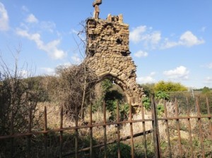
By the time I passed underneath the M4 for the last time and rounded Sudbrook, the look and feel of the Path changed with the coast appearing to give way to an estuary. Sudbrook is famous for the historical attempt to tunnel underneath the Severn. Today, the railway passes underneath Sudbrook, but has its entry point some two miles to the west. I take a while to explore the 12th century Holy Trinity chapel, in ruins since 1720. Parts of the chapel and graveyard have been lost to the action of the sea over time.

The first Severn Bridge comes into view, the M48. I follow a short section of seawall and cross the railway as I head inland. This will be my last coast section, as when the path emerges later on it will alongside the banks of the River Wye. I head towards the quiet village of Mathern, although, there is still the hum of the distant motorway. As I pass by the church in Mathern, I notice an elaborately carved figure of the Celtic King of Gwent – Tewdrig. The story goes that Tewdrig was mortally wounded in a battle with the Saxons. As he was being carried to be buried on Flat Holm island, he died where the Church now stands.

The final three miles is spent walking around distribution warehouses, motorways and the mundane suburbia of Chepstow. Nevertheless Chepstow is a lovely little market town, with dramatic cliffs as the River Wye cuts its way through to the Severn Estuary. The Start/ End of the Wales Coast path is at the elegantly styled Old Wye Bridge or Town Bridge that links Wales to England. The bridge is now 200 years old. Previously the site of a wooden bridge and ferry point during Roman times, this place is a fitting place to end my walk.

I peruse the various sculptures and signs in the nearby “The Backs” and walk across the bridge into Gloucestershire. One particular feature catches my eye. It is a sort of mosaic which links the nearby Offa’s Dyke with the WCP and an association of various counties, walks and birds, It is really well done

In retrospect I have thoroughly enjoyed walking the Wales Coast Path and although my challenge has changed en route to include the whole of the coast of Great Britain; it would not have been right not include the small section at Chepstow. I have found the WCP to be, in the main, very well signposted (probably better than the SWCP!), well served by bus and trains and offering a stunning variety of wildlife and scenery.
Now I must link up the end of the SWCP at Minehead with Chepstow.
Distance today = 18 miles
Total distance = 1545 miles
